Rogart: Difference between revisions
Appearance
Content deleted Content added
Pronunciation |
No edit summary |
||
| (13 intermediate revisions by 7 users not shown) | |||
| Line 2: | Line 2: | ||
{{Use dmy dates|date=October 2019}} |
{{Use dmy dates|date=October 2019}} |
||
{{Infobox UK place |
{{Infobox UK place |
||
| static_image_name = St Callan's Church in Rogart - geograph.org.uk - 62330.jpg |
|||
| static_image_caption = St Callan's Church in Rogart |
|||
| country = Scotland |
|||
| official_name = Rogart |
|||
| scots_name = |
|||
| gaelic_name = Sgìre Raoird |
|||
| population = |
|||
| os_grid_reference = NC745034 |
|||
| map_type = Sutherland |
|||
| coordinates = {{coord|58.00264|-4.12408|display=inline,title}} |
|||
| unitary_scotland = [[Highland (council area)|Highland]] |
|||
| lieutenancy_scotland = [[Sutherland]] |
|||
| constituency_westminster = [[Caithness, Sutherland and Easter Ross (UK Parliament constituency)|Caithness, Sutherland and Easter Ross]] |
|||
| constituency_scottish_parliament = [[Caithness, Sutherland and Ross (Scottish Parliament constituency)|Caithness, Sutherland and Ross]] |
|||
| post_town = Rogart |
|||
| postcode_district = IV28 |
|||
| postcode_area = IV |
|||
| dial_code = |
|||
}} |
|||
'''Rogart''' ({{IPAc-en|ˈ|r|oʊ|ɡ|ɑːr|t}} {{respell|ROH|gart}}, {{ |
'''Rogart''' ({{IPAc-en|ˈ|r|oʊ|ɡ|ɑːr|t}} {{respell|ROH|gart}}, {{Langx|gd|Sgìre Raoird ''or'' Raoghard|italic=invert}}, meaning "great enclosed field")<ref>[http://www.snh.org.uk/pdfs/publications/gaelic/gaelicnorseinthelandscape.pdf Gaelic and Norse in the Landscape: Placenames in Caithness and Sutherland]. Scottish National Heritage.</ref> is a parish in [[Sutherland]], [[Highland Council area|Highland]], [[Scotland]]. The parish was the home of Major Andrew MacDonald, who fought in the [[French and Indian War]].<ref> |
||
[https://archive.org/stream/annalsnorthbri00nort#page/19/mode/1up Annals, North British Society]</ref> |
[https://archive.org/stream/annalsnorthbri00nort#page/19/mode/1up Annals, North British Society]</ref> |
||
[[File:Andrew MacDonald (1721 - 1812).png|thumb|right|upright|Andrew MacDonald (1721–1812)]] |
[[File:Andrew MacDonald (1721 - 1812).png|thumb|right|upright|Andrew MacDonald (1721–1812)]] |
||
It was originally a scattered [[crofting]] |
It was originally a scattered [[crofting]] parish centred on the parish church of St Callan's, until the opening of the [[Rogart railway station]] at [[Pittentrail]] {{convert|1+1/2|mi|km}} to the southeast. The locus of the parish shifted when a new 'industrial' village grew around Pittentrail following the arrival of the railway in 1886.<ref>{{cite web |url=http://www.scottishplaces.info/towns/townfirst1763.html |title=Rogart |work=Gazetteer for Scotland |accessdate=15 December 2014}}</ref> |
||
The village of [[Golspie]] is {{convert|9|mi|km}} east of Rogart. |
The village of [[Golspie]] is {{convert|9|mi|km}} east of Rogart whilst Lairg is 10 miles west. |
||
{{clear left}} |
{{clear left}} |
||
| Line 36: | Line 36: | ||
[[Category:Populated places in Sutherland]] |
[[Category:Populated places in Sutherland]] |
||
[[Category:Parishes in Sutherland]] |
|||
Latest revision as of 14:21, 16 November 2024
Rogart
| |
|---|---|
 St Callan's Church in Rogart | |
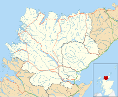
Location within the Sutherland area | |
| OS grid reference | NC745034 |
| Council area | |
| Lieutenancy area | |
| Country | Scotland |
| Sovereign state | United Kingdom |
| Post town | Rogart |
| Postcode district | IV28 |
| Police | Scotland |
| Fire | Scottish |
| Ambulance | Scottish |
| UK Parliament | |
| Scottish Parliament | |
Rogart (/ˈroʊɡɑːrt/ ROH-gart, Scottish Gaelic: Sgìre Raoird or Raoghard, meaning "great enclosed field")[1] is a parish in Sutherland, Highland, Scotland. The parish was the home of Major Andrew MacDonald, who fought in the French and Indian War.[2]

It was originally a scattered crofting parish centred on the parish church of St Callan's, until the opening of the Rogart railway station at Pittentrail 1+1⁄2 miles (2.4 km) to the southeast. The locus of the parish shifted when a new 'industrial' village grew around Pittentrail following the arrival of the railway in 1886.[3]
The village of Golspie is 9 miles (14 km) east of Rogart whilst Lairg is 10 miles west.
References
[edit]Wikimedia Commons has media related to Rogart.
- ^ Gaelic and Norse in the Landscape: Placenames in Caithness and Sutherland. Scottish National Heritage.
- ^ Annals, North British Society
- ^ "Rogart". Gazetteer for Scotland. Retrieved 15 December 2014.

