Langezwaag: Difference between revisions
Appearance
Content deleted Content added
No edit summary Tags: Mobile edit Mobile web edit |
No edit summary |
||
| (One intermediate revision by one other user not shown) | |||
| Line 4: | Line 4: | ||
| native_name_lang = <!-- ISO 639-2 code e.g. "fr" for French. If more than one, use {{lang}} instead --> |
| native_name_lang = <!-- ISO 639-2 code e.g. "fr" for French. If more than one, use {{lang}} instead --> |
||
| settlement_type = Village |
| settlement_type = Village |
||
| image_skyline = |
| image_skyline = Langsweagen, Mattéustsjerke.jpg |
||
| image_alt = |
| image_alt = |
||
| image_caption = Langezwaag church |
| image_caption = Langezwaag church |
||
| Line 71: | Line 71: | ||
| footnotes = |
| footnotes = |
||
}} |
}} |
||
'''Langezwaag''' ({{ |
'''Langezwaag''' ({{langx|fy|Langsweagen}}) is a [[village]] in the municipality of [[Opsterland]] in the east of [[Friesland]], the [[Netherlands]]. It had a population of around 1,365 in January 2017.<ref>[http://statline.cbs.nl/Statweb/publication/?DM=SLNL&PA=83765NED&D1=0-1,3-4,8,11,14,28,31-32,99-104&D2=11316-11351&HDR=T&STB=G1&VW=T Kerncijfers wijken en buurten 2017] - CBS Statline</ref> |
||
==History== |
==History== |
||
Latest revision as of 18:15, 20 November 2024
Langezwaag
Langsweagen | |
|---|---|
Village | |
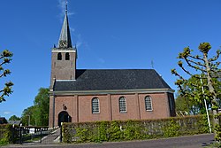
 Langezwaag church | |
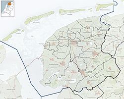
 Location in Opsterland municipality | |
| Coordinates: 52°58′59″N 6°0′16″E / 52.98306°N 6.00444°E | |
| Country | |
| Province | |
| Municipality | |
| Area | |
• Total | 13.17 km2 (5.08 sq mi) |
| Elevation | 0.5 m (1.6 ft) |
| Population (2021)[1] | |
• Total | 1,050 |
| • Density | 80/km2 (210/sq mi) |
| Postal code | 8404[1] |
| Dialing code | 0513 |
Langezwaag (West Frisian: Langsweagen) is a village in the municipality of Opsterland in the east of Friesland, the Netherlands. It had a population of around 1,365 in January 2017.[3]
History
[edit]The village was first mentioned in 1315 as Utresuagh, and means "long meadow with caddle". Lange (long) has been added to distinguish from Kortezwaag.[4] Kortezwaag was annexed by Gorredijk in 1962 and is now a neighbourhood.[5] The Dutch Reformed church was built in 1781 as a replacement of a medieval church.
Langezwaag was home to 956 people in 1840.[6]
Gallery
[edit]-
Welcome to Langezwaag
-
The tree of Langezwaag
References
[edit]- ^ a b c "Kerncijfers wijken en buurten 2021". Central Bureau of Statistics. Retrieved 2 April 2022.
- ^ "Postcodetool for 8404BJ". Actueel Hoogtebestand Nederland (in Dutch). Het Waterschapshuis. Retrieved 2 April 2022.
- ^ Kerncijfers wijken en buurten 2017 - CBS Statline
- ^ "Langezwaag". Etymologiebank (in Dutch). Retrieved 2 April 2022.
- ^ "Kortezwaag". Plaatsengids (in Dutch). Retrieved 2 April 2022.
- ^ "Langezwaag". Plaatsengids (in Dutch). Retrieved 2 April 2022.
![]() Media related to Langezwaag at Wikimedia Commons
Media related to Langezwaag at Wikimedia Commons


