Gangseo District, Busan: Difference between revisions
No edit summary Tags: Mobile edit Mobile web edit |
Victorkamat (talk | contribs) No edit summary |
||
| (7 intermediate revisions by 4 users not shown) | |||
| Line 1: | Line 1: | ||
{{For|the district of the same name located in |
{{For|the district of the same name located in Seoul|Gangseo District, Seoul}} |
||
{{Infobox settlement |
{{Infobox settlement |
||
| name = Gangseo |
| name = Gangseo |
||
| Line 7: | Line 7: | ||
| translit_lang1 = Korean |
| translit_lang1 = Korean |
||
| translit_lang1_type1 = Hanja |
| translit_lang1_type1 = Hanja |
||
| translit_lang1_info1 |
| translit_lang1_info1 = 江西區 |
||
| translit_lang1_type2 = {{nowrap|Revised Romanization}} |
| translit_lang1_type2 = {{nowrap|Revised Romanization}} |
||
| translit_lang1_info2 = Gangseo-gu |
| translit_lang1_info2 = Gangseo-gu |
||
| translit_lang1_type3 = {{nowrap| |
| translit_lang1_type3 = {{nowrap|McCune–Reischauer}} |
||
| translit_lang1_info3 = |
| translit_lang1_info3 = Kangsŏ-gu |
||
| image_skyline = Gaduk Bridge constructing.jpg |
| image_skyline = Gaduk Bridge constructing.jpg |
||
| imagesize = |
| imagesize = |
||
| Line 20: | Line 20: | ||
| image_blank_emblem = Gangseo-gu (Busan) logo.png |
| image_blank_emblem = Gangseo-gu (Busan) logo.png |
||
| subdivision_type = Country |
| subdivision_type = Country |
||
| subdivision_name = |
| subdivision_name = South Korea |
||
| subdivision_type1 = [[Regions of Korea|Region]] |
| subdivision_type1 = [[Regions of Korea|Region]] |
||
| subdivision_name1 = [[Yeongnam]] |
| subdivision_name1 = [[Yeongnam]] |
||
| subdivision_type2 = [[Provinces of South Korea|Provincial level]] |
| subdivision_type2 = [[Provinces of South Korea|Provincial level]] |
||
| subdivision_name2 = [[Busan]] |
| subdivision_name2 = [[Busan]] |
||
<!-- government type, leaders -->| government_footnotes = <!-- for references: use <ref> tags --> |
|||
| leader_party = |
|||
| leader_title = Mayor |
|||
| leader_name =Kim Hyeong-chan(김형찬) |
|||
| subdivision_type3 = [[Administrative divisions of South Korea|Administrative divisions]] |
| subdivision_type3 = [[Administrative divisions of South Korea|Administrative divisions]] |
||
| subdivision_name3 = 8 administrative ''dong'' |
| subdivision_name3 = 8 administrative ''dong'' |
||
| Line 31: | Line 35: | ||
| parts_type = |
| parts_type = |
||
| parts = |
| parts = |
||
| area_total_km2 = |
| area_total_km2 = 181.05 |
||
| population_as_of = |
| population_as_of = 2024<ref>{{cite web |url=https://jumin.mois.go.kr/|title=Population statistics |date=2024|website=Korea Ministry of the Interior and Safety}}</ref> |
||
| population_total = |
| population_total = 142,902 |
||
| population_density_km2 = auto |
| population_density_km2 = auto |
||
| population_blank1_title = Dialect |
| population_blank1_title = Dialect |
||
| population_blank1 = [[Gyeongsang dialect|Gyeongsang]] |
| population_blank1 = [[Gyeongsang dialect|Gyeongsang]] |
||
| website = {{ |
| website = {{URL|http://www.bsgangseo.go.kr/|Gangseo District Office}} |
||
| image_flag = Flag of Gangseo, Busan.svg |
| image_flag = Flag of Gangseo, Busan.svg |
||
}} |
}} |
||
| Line 44: | Line 48: | ||
[[File:Gangseo-gu(Busan) north.jpg|thumbnail|Farmland]] |
[[File:Gangseo-gu(Busan) north.jpg|thumbnail|Farmland]] |
||
'''Gangseo District''' ( |
'''Gangseo District''' ({{Korean|hangul=강서구|rr=Gangseo-gu}}) is a ''[[Subdivisions of South Korea|gu]]'' on the west side of [[Nakdong River]] in [[Busan]], South Korea. It has an area of 179.05 km<sup>2</sup>, and a population of about 66,000; it has a lower population density than [[Gijang County]] of [[Busan]]. Gangseo-gu was part of [[Buk-gu (Busan)|Buk-gu]] from its creation in 1978 to 1989 when it became an independent ''gu''. |
||
Gangseo-gu is the westernmost ''gu'' in Busan and it shares a common borders with [[Gimhae]] on its north-west side and [[Jinhae |
Gangseo-gu is the westernmost ''gu'' in Busan and it shares a common borders with [[Gimhae]] on its north-west side and [[Jinhae District]], [[Changwon]] on its south-west side. |
||
Gangseo-gu is the birthplace of the [[Gaya confederacy|Gaya civilization]]. |
Gangseo-gu is the birthplace of the [[Gaya confederacy|Gaya civilization]]. |
||
Latest revision as of 02:03, 21 November 2024
Gangseo
강서구 | |
|---|---|
| Korean transcription(s) | |
| • Hanja | 江西區 |
| • Revised Romanization | Gangseo-gu |
| • McCune–Reischauer | Kangsŏ-gu |
 | |
 | |
| Country | South Korea |
| Region | Yeongnam |
| Provincial level | Busan |
| Administrative divisions | 8 administrative dong |
| Government | |
| • Mayor | Kim Hyeong-chan(김형찬) |
| Area | |
• Total | 181.05 km2 (69.90 sq mi) |
| Population (2024[1]) | |
• Total | 142,902 |
| • Density | 790/km2 (2,000/sq mi) |
| • Dialect | Gyeongsang |
| Website | Gangseo District Office |


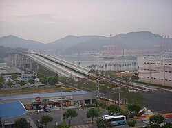
Gangseo District (Korean: 강서구; RR: Gangseo-gu) is a gu on the west side of Nakdong River in Busan, South Korea. It has an area of 179.05 km2, and a population of about 66,000; it has a lower population density than Gijang County of Busan. Gangseo-gu was part of Buk-gu from its creation in 1978 to 1989 when it became an independent gu.
Gangseo-gu is the westernmost gu in Busan and it shares a common borders with Gimhae on its north-west side and Jinhae District, Changwon on its south-west side.
Gangseo-gu is the birthplace of the Gaya civilization.
Gimhae International Airport, Heungguk Temple, Myeongwol Temple, as well as the Eulsukdo bird sanctuary are located in Gangseo-gu.
Administrative divisions
[edit]
Gangseo-gu is divided into 22 legal dong. They have been grouped together to form only 7 administrative dong, as follows:
- Daejeo 1-dong
- Daejeo 2-dong
- Gangdong-dong
- Myeongji 1-dong
- Myeongji 2-dong
- Garak-dong (4 legal dong)
- Jukrim-dong, Sikman-dong, Jukdong-dong, Bongnim-dong
- Noksan-dong (9 legal dong)
- Songjeong-dong, Hwajeon-dong, Noksan-dong, Saenggok-dong, Gurang-dong, Jisa-dong, Mieum-dong, Beombang-dong, Sinho-dong
- Gadeokdo-dong (5 legal dong)
- Dongseon-dong, Seongbuk-dong, Nulcha-dong, Cheonseong-dong, Daehang-dong
See also
[edit]References
[edit]- ^ "Population statistics". Korea Ministry of the Interior and Safety. 2024.
External links
[edit]- Gangseo-gu website (in English)
35°12′25″N 128°58′50″E / 35.20694°N 128.98056°E


