Thái Bình: Difference between revisions
No edit summary |
No edit summary Tags: Mobile edit Mobile web edit Advanced mobile edit |
||
| (12 intermediate revisions by 7 users not shown) | |||
| Line 1: | Line 1: | ||
{{Infobox settlement |
{{Infobox settlement |
||
<!-- See Template:Infobox settlement for additional fields and descriptions --> |
<!-- See Template:Infobox settlement for additional fields and descriptions --> |
||
<!-- Basic info ---------------->| name = |
<!-- Basic info ---------------->| name = Thái Bình (City) |
||
| official_name = |
| official_name = Thái Bình City |
||
| other_name = |
| other_name = |
||
| native_name = |
| native_name = Thành phố Thái Bình |
||
| nickname = |
| nickname = |
||
| settlement_type = [[Provincial city (Vietnam)|City (Class-2)]]<!-- e.g. Town, Village, City, etc.--> |
| settlement_type = [[Provincial city (Vietnam)|City (Class-2)]]<!-- e.g. Town, Village, City, etc.--> |
||
| total_type = <!-- to set a non-standard label for total area and population rows --> |
| total_type = <!-- to set a non-standard label for total area and population rows --> |
||
| motto = <!-- images and maps -----------> |
| motto = <!-- images and maps -----------> |
||
| image_skyline = |
| image_skyline = Bao tang Thai Binh.jpg |
||
| imagesize = |
| imagesize = |
||
| image_caption = |
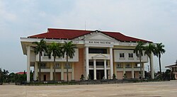
| image_caption = Thái Bình Provincial Museum in Thái Bình City |
||
| flag_size = |
| flag_size = |
||
| image_seal = |
| image_seal = |
||
| Line 31: | Line 31: | ||
| dot_x = |
| dot_x = |
||
| dot_y = |
| dot_y = |
||
| pushpin_map = Vietnam <!-- the name of a location map as per http://en.wikipedia.org/wiki/Template:Location_map --> |
| pushpin_map = Vietnam#Southeast Asia#Asia <!-- the name of a location map as per http://en.wikipedia.org/wiki/Template:Location_map --> |
||
| pushpin_label_position = <!-- the position of the pushpin label: left, right, top, bottom, none --> |
| pushpin_label_position = <!-- the position of the pushpin label: left, right, top, bottom, none --> |
||
| pushpin_map_caption = Location of |
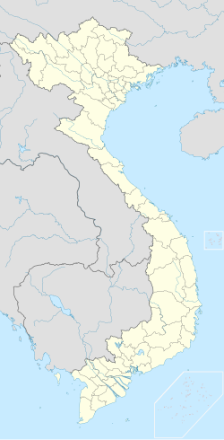
| pushpin_map_caption = Location of Thái Bình in Vietnam |
||
| pushpin_mapsize = 250 |
| pushpin_mapsize = 250 |
||
<!-- Location ------------------>| subdivision_type = Country |
<!-- Location ------------------>| subdivision_type = Country |
||
| subdivision_name = {{flag| |
| subdivision_name = {{flag|Vietnam}} |
||
| subdivision_type1 = [[Provinces of |
| subdivision_type1 = [[Provinces of Vietnam|Province]] |
||
| subdivision_name1 = [[ |
| subdivision_name1 = [[Thái Bình Province|Thái Bình]] |
||
| subdivision_type2 = |
| subdivision_type2 = |
||
| subdivision_name2 = |
| subdivision_name2 = |
||
| Line 85: | Line 85: | ||
| website = |
| website = |
||
| footnotes = |
| footnotes = |
||
| blank_name_sec2 = [[Köppen climate classification|Climate]] |
|||
| blank_info_sec2 = [[Humid subtropical climate|Cwa]] |
|||
}} |
}} |
||
'''Thái Bình City''' ({{Audio|Thai Binh.ogg|listen|help=no}}) is a city in the [[Red River Delta]] of Northern [[Vietnam]]. It is the capital of [[Thái Bình Province]]. The city is located 110 km from [[Hanoi]]. The city area is 67.7 square km, with a population of 210,000 people (2006). |
|||
==History== |
==History== |
||
[[Image:Nha Van Hoa Lao Dong Thai Binh.jpg|left|300px|thumb|The |
[[Image:Nha Van Hoa Lao Dong Thai Binh.jpg|left|300px|thumb|The Workers' House of Culture]] |
||
In the 10th century, the area was the domain of |
In the 10th century, the area was the domain of the Tran clan, which rose in power to become the [[Trần Dynasty]] of Vietnam in the early 13th century. The town Thái Bình (Sino-Vietnamese: 太平) developed near the [[Keo Pagoda]] constructed in 1061. |
||
Before the prime minister |
Before the prime minister declared it a city in June 2004, Thai Binh was officially a town. The city is the center of economics and culture in its province. [[Thai Binh Medical College]] is considered one of the highest quality [[Medicine|medical]] colleges in Vietnam.<ref>''BMJ: British Medical Journal'' - Volume 313, Issues 7061-7072 1996- Page 1115 "Data from Thai Binh reproductive health survey, April 1992, on 347 mothers delivering for first time from April 1987 to ... We thank the participating women in this survey, our colleagues at Thai Binh Medical College, and the staff of Centre for ..."</ref> |
||
==Climate== |
==Climate== |
||
| Line 99: | Line 101: | ||
|metric first=y |
|metric first=y |
||
|single line=y |
|single line=y |
||
|location = |
|location = Thái Bình |
||
|Jan high C = |
|Jan high C = 19.4 |
||
|Feb high C = 19.7 |
|Feb high C = 19.7 |
||
|Mar high C = 22.1 |
|Mar high C = 22.1 |
||
| Line 142: | Line 144: | ||
|Feb record high C = 34.6 |Feb record low C = 5.5 |
|Feb record high C = 34.6 |Feb record low C = 5.5 |
||
|Mar record high C = 35.9 |Mar record low C = 6.7 |
|Mar record high C = 35.9 |Mar record low C = 6.7 |
||
|Apr record high C = |
|Apr record high C = 39.0 |Apr record low C = 12.8 |
||
|May record high C = 38.2 |May record low C = 16.9 |
|May record high C = 38.2 |May record low C = 16.9 |
||
|Jun record high C = 39.2 |Jun record low C = 19.4 |
|Jun record high C = 39.2 |Jun record low C = 19.4 |
||
|Jul record high C = 39.2 |Jul record low C = 21.9 |
|Jul record high C = 39.2 |Jul record low C = 21.9 |
||
|Aug record high C = |
|Aug record high C = 38.0 |Aug record low C = 21.6 |
||
|Sep record high C = 36.3 |Sep record low C = 16.5 |
|Sep record high C = 36.3 |Sep record low C = 16.5 |
||
|Oct record high C = |
|Oct record high C = 34.5 |Oct record low C = 11.6 |
||
|Nov record high C = 32. |
|Nov record high C = 32.6 |Nov record low C = 9.1 |
||
|Dec record high C = 30.1 |Dec record low C = 4.4 |
|Dec record high C = 30.1 |Dec record low C = 4.4 |
||
|year record high C = 39.2 |year record low C = 4.1 |
|year record high C = 39.2 |year record low C = 4.1 |
||
| |
|rain colour = green |
||
|Jan |
|Jan rain mm = 29.3 |
||
|Feb |
|Feb rain mm = 25.5 |
||
|Mar |
|Mar rain mm = 46.9 |
||
|Apr |
|Apr rain mm = 78.4 |
||
|May |
|May rain mm = 159.9 |
||
|Jun |
|Jun rain mm = 186.8 |
||
|Jul |
|Jul rain mm = 223.8 |
||
|Aug |
|Aug rain mm = 302.0 |
||
|Sep |
|Sep rain mm = 329.5 |
||
|Oct |
|Oct rain mm = 203.7 |
||
|Nov |
|Nov rain mm = 69.0 |
||
|Dec |
|Dec rain mm = 25.5 |
||
|year |
|year rain mm = 1680.3 |
||
|Jan rain days = 9.4 |
|Jan rain days = 9.4 |
||
|Feb rain days = 13.1 |
|Feb rain days = 13.1 |
||
| Line 205: | Line 207: | ||
|Dec sun = 111.8 |
|Dec sun = 111.8 |
||
|year sun = 1556.5 |
|year sun = 1556.5 |
||
|source 1 = Vietnam Institute for Building Science and Technology<ref name=IBST>{{cite web|title=Vietnam Institute for Building Science and Technology|url=https://datafiles.chinhphu.vn/cpp/files/vbpq/2022/10/02-bxd.pdf |
|source 1 = Vietnam Institute for Building Science and Technology<ref name=IBST>{{cite web|title=Vietnam Institute for Building Science and Technology|url=https://datafiles.chinhphu.vn/cpp/files/vbpq/2022/10/02-bxd.pdf |lang=en}}</ref> |
||
}} |
}} |
||
| Line 224: | Line 226: | ||
{{Authority control}} |
{{Authority control}} |
||
{{DEFAULTSORT: |
{{DEFAULTSORT:Thai Binh}} |
||
[[Category:Populated places in |
[[Category:Populated places in Thái Bình province]] |
||
[[Category:Provincial capitals in Vietnam]] |
[[Category:Provincial capitals in Vietnam]] |
||
[[Category:Districts of |
[[Category:Districts of Thái Bình province]] |
||
[[Category:Cities in Vietnam]] |
[[Category:Cities in Vietnam]] |
||
Revision as of 04:54, 22 November 2024
Thái Bình (City)
Thành phố Thái Bình | |
|---|---|
| Thái Bình City | |
 Thái Bình Provincial Museum in Thái Bình City | |
 | |
| Coordinates: 20°26′46″N 106°20′32″E / 20.44611°N 106.34222°E | |
| Country | |
| Province | Thái Bình |
| Established | 29 April 2004 |
| Area | |
• Total | 67.7135 km2 (26.1443 sq mi) |
| Population (2013) | |
• Total | 268,167 |
| • Density | 3,961/km2 (10,260/sq mi) |
| Climate | Cwa |
Thái Bình City (ⓘ) is a city in the Red River Delta of Northern Vietnam. It is the capital of Thái Bình Province. The city is located 110 km from Hanoi. The city area is 67.7 square km, with a population of 210,000 people (2006).
History

In the 10th century, the area was the domain of the Tran clan, which rose in power to become the Trần Dynasty of Vietnam in the early 13th century. The town Thái Bình (Sino-Vietnamese: 太平) developed near the Keo Pagoda constructed in 1061.
Before the prime minister declared it a city in June 2004, Thai Binh was officially a town. The city is the center of economics and culture in its province. Thai Binh Medical College is considered one of the highest quality medical colleges in Vietnam.[1]
Climate
| Climate data for Thái Bình | |||||||||||||
|---|---|---|---|---|---|---|---|---|---|---|---|---|---|
| Month | Jan | Feb | Mar | Apr | May | Jun | Jul | Aug | Sep | Oct | Nov | Dec | Year |
| Record high °C (°F) | 31.7 (89.1) |
34.6 (94.3) |
35.9 (96.6) |
39.0 (102.2) |
38.2 (100.8) |
39.2 (102.6) |
39.2 (102.6) |
38.0 (100.4) |
36.3 (97.3) |
34.5 (94.1) |
32.6 (90.7) |
30.1 (86.2) |
39.2 (102.6) |
| Mean daily maximum °C (°F) | 19.4 (66.9) |
19.7 (67.5) |
22.1 (71.8) |
26.3 (79.3) |
30.5 (86.9) |
32.5 (90.5) |
32.5 (90.5) |
31.6 (88.9) |
30.4 (86.7) |
28.4 (83.1) |
25.3 (77.5) |
21.7 (71.1) |
26.7 (80.1) |
| Daily mean °C (°F) | 16.3 (61.3) |
17.2 (63.0) |
19.6 (67.3) |
23.4 (74.1) |
27.0 (80.6) |
28.8 (83.8) |
29.2 (84.6) |
28.4 (83.1) |
27.1 (80.8) |
24.6 (76.3) |
21.4 (70.5) |
17.9 (64.2) |
23.4 (74.1) |
| Mean daily minimum °C (°F) | 14.2 (57.6) |
15.5 (59.9) |
17.9 (64.2) |
21.5 (70.7) |
24.5 (76.1) |
26.2 (79.2) |
26.7 (80.1) |
25.9 (78.6) |
24.6 (76.3) |
21.9 (71.4) |
18.5 (65.3) |
15.1 (59.2) |
21.0 (69.8) |
| Record low °C (°F) | 4.1 (39.4) |
5.5 (41.9) |
6.7 (44.1) |
12.8 (55.0) |
16.9 (62.4) |
19.4 (66.9) |
21.9 (71.4) |
21.6 (70.9) |
16.5 (61.7) |
11.6 (52.9) |
9.1 (48.4) |
4.4 (39.9) |
4.1 (39.4) |
| Average rainfall mm (inches) | 29.3 (1.15) |
25.5 (1.00) |
46.9 (1.85) |
78.4 (3.09) |
159.9 (6.30) |
186.8 (7.35) |
223.8 (8.81) |
302.0 (11.89) |
329.5 (12.97) |
203.7 (8.02) |
69.0 (2.72) |
25.5 (1.00) |
1,680.3 (66.15) |
| Average rainy days | 9.4 | 13.1 | 16.5 | 12.6 | 12.4 | 12.6 | 12.7 | 15.8 | 15.1 | 11.8 | 7.7 | 6.3 | 146.1 |
| Average relative humidity (%) | 85.5 | 88.6 | 90.3 | 90.0 | 86.5 | 83.5 | 82.8 | 86.8 | 87.0 | 84.6 | 82.6 | 82.5 | 85.9 |
| Mean monthly sunshine hours | 68.9 | 39.8 | 38.9 | 90.0 | 190.0 | 184.2 | 203.6 | 170.2 | 170.2 | 161.8 | 135.8 | 111.8 | 1,556.5 |
| Source: Vietnam Institute for Building Science and Technology[2] | |||||||||||||
References
- ^ BMJ: British Medical Journal - Volume 313, Issues 7061-7072 1996- Page 1115 "Data from Thai Binh reproductive health survey, April 1992, on 347 mothers delivering for first time from April 1987 to ... We thank the participating women in this survey, our colleagues at Thai Binh Medical College, and the staff of Centre for ..."
- ^ "Vietnam Institute for Building Science and Technology" (PDF).
External links
20°26′46″N 106°20′32″E / 20.446111°N 106.342222°E


