Mana, Chamoli: Difference between revisions
m →Demography: clean up |
m Updating the Commons category from "Category:Mana, Uttarakhand" to "Category:Mana, Chamoli" to avoid a category redirect |
||
| (22 intermediate revisions by 17 users not shown) | |||
| Line 1: | Line 1: | ||
{{Use dmy dates|date=August 2017}} |
{{Use dmy dates|date=August 2017}} |
||
{{Use Indian English|date=August 2017}} |
{{Use Indian English|date=August 2017}} |
||
{{Short description|Village in Chamoli of Uttrakhand}} |
|||
{{Infobox settlement |
{{Infobox settlement |
||
| name = Mana |
| name = Mana |
||
| native_name = |
|||
| other_name = |
|||
| settlement_type = Village |
| settlement_type = Village |
||
| |
| image_skyline = India lsat village.jpg |
||
| image_caption = Gateway to Mana village |
| image_caption = Gateway to Mana village |
||
| nickname = |
| nickname = |
||
| Line 43: | Line 46: | ||
| footnotes = |
| footnotes = |
||
}} |
}} |
||
'''Mana''' is a [[village]] in the district of [[Chamoli]] in the [[States and territories of India|Indian state]] of [[Uttarakhand]], located at an altitude of 3,200 meters.<ref name=bisht>{{cite book|last=Bisht|first=Harshwanti|title=Tourism in Garhwal Himalaya : with special reference to mountaineering and trekking in Uttarkashi and Chamoli Districts|year=1994|publisher=Indus Pub. Co.|location=New Delhi|isbn=9788173870064|pages=90–92|url=https://books.google.com/?id=6C6DGU73WzsC |
'''Mana''' is a [[village]] in the district of [[Chamoli]] in the [[States and territories of India|Indian state]] of [[Uttarakhand]], located at an altitude of 3,200 meters {10,500 feet}.<ref name=bisht>{{cite book|last=Bisht|first=Harshwanti|title=Tourism in Garhwal Himalaya : with special reference to mountaineering and trekking in Uttarkashi and Chamoli Districts|year=1994|publisher=Indus Pub. Co.|location=New Delhi|isbn=9788173870064|pages=90–92|url=https://books.google.com/books?id=6C6DGU73WzsC&q=Mana&pg=PA43}}</ref> It is located on the northern terminus of [[National Highway 7 (India)|National Highway 7 (new numbering system)]],<ref>{{cite web |
||
|url = http://www.mapsofindia.com/driving-directions-maps/nh58-driving-directions-map.html |
|url = http://www.mapsofindia.com/driving-directions-maps/nh58-driving-directions-map.html |
||
|title = National Highway No. 58 |
|title = National Highway No. 58 |
||
|publisher = Maps of India |
|publisher = Maps of India |
||
| |
|access-date = 2010-08-07}}</ref> Mana is the first village before the [[Mana Pass]] and is 26 kilometres from the border of India and [[Tibet]]. The village is at a distance of about 3 km from the Hindu Pilgrimage [[Badrinath]] and the two places are culturally connected with each other.<ref name=bisht/> |
||
==Demography== |
==Demography== |
||
| Line 55: | Line 58: | ||
|date = 9 Nov 2008 |
|date = 9 Nov 2008 |
||
|author = Raju Gusain |
|author = Raju Gusain |
||
| |
|access-date = 2010-08-07 |
||
|archive-url = https://web.archive.org/web/20110721043555/http://content.msn.co.in/MSNContribute/Story.aspx?PageID=5a1aeaec-fa67-4d2a-aa48-10a276848557 |
|||
|archive-date = 21 July 2011 |
|||
|url-status = dead |
|||
}}</ref> |
|||
==Cultural identity== |
==Cultural identity== |
||
The villagers of this village are culturally associated with activities of Badrinath temple and annual fair of Matha murthi.<ref name=bisht/> They used to trade with Tibet in earlier days.<ref name=bisht/> There is a small cave in Mana, named Vyas Gufa and it is believed that Maharshi [[Vyas]] composed |
The villagers of this village are culturally associated with activities of Badrinath temple and annual fair of Matha murthi.<ref name=bisht/> They used to trade with Tibet in earlier days.<ref name=bisht/> There is a small cave in Mana, named Vyas Gufa and it is believed that Maharshi [[Vyas]] composed Mahabharat in this cave.<ref name=bisht/> One more cave is called Ganesh Gufa and tourists visit both caves regularly. |
||
==Other destinations== |
==Other destinations== |
||
Nearby places |
Nearby places include [[Vasudhara Falls]], [[Satopanth Tal|Satopanth Lake]], Bhim Pul, Saraswati Temple etc.{{Citation needed|date=June 2013}} |
||
==See also== |
|||
*[[Niti Valley]] |
|||
== References == |
== References == |
||
{{reflist}} |
{{reflist}} |
||
{{Commons category|Mana, |
{{Commons category|Mana, Chamoli}} |
||
{{Chamoli district}} |
{{Chamoli district}} |
||
Latest revision as of 12:32, 22 November 2024
Mana | |
|---|---|
Village | |
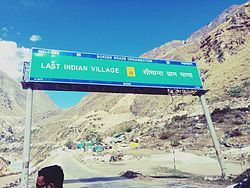
 Gateway to Mana village | |
| Coordinates: 30°46′19″N 79°29′43″E / 30.77194°N 79.49528°E | |
| Country | India |
| State | Uttarakhand |
| District | Chamoli |
| Elevation | 3,200 m (10,500 ft) |
| Population (2011) | |
• Total | 1,214 |
| Languages | |
| • Official | Hindi, Garhwali |
| Time zone | UTC+5:30 (IST) |
| Vehicle registration | UK 11 |
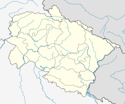
Mana is a village in the district of Chamoli in the Indian state of Uttarakhand, located at an altitude of 3,200 meters {10,500 feet}.[1] It is located on the northern terminus of National Highway 7 (new numbering system),[2] Mana is the first village before the Mana Pass and is 26 kilometres from the border of India and Tibet. The village is at a distance of about 3 km from the Hindu Pilgrimage Badrinath and the two places are culturally connected with each other.[1]
Demography
[edit]As per Census 2011 the village had about 558 households and a population of about 1214.[3] The people belong to Marchhas and Jads or Bhotias.[1] During winter months, the entire populations comes down to lower places, as the area is covered under snow.[1] Many coffee shops here tell people that their shop is the last coffee shop on the Indian border.[4]
Cultural identity
[edit]The villagers of this village are culturally associated with activities of Badrinath temple and annual fair of Matha murthi.[1] They used to trade with Tibet in earlier days.[1] There is a small cave in Mana, named Vyas Gufa and it is believed that Maharshi Vyas composed Mahabharat in this cave.[1] One more cave is called Ganesh Gufa and tourists visit both caves regularly.
Other destinations
[edit]Nearby places include Vasudhara Falls, Satopanth Lake, Bhim Pul, Saraswati Temple etc.[citation needed]
See also
[edit]References
[edit]- ^ a b c d e f g Bisht, Harshwanti (1994). Tourism in Garhwal Himalaya : with special reference to mountaineering and trekking in Uttarkashi and Chamoli Districts. New Delhi: Indus Pub. Co. pp. 90–92. ISBN 9788173870064.
- ^ "National Highway No. 58". Maps of India. Retrieved 7 August 2010.
- ^ "Mana, Uttarakhand census 2011 data". Office of the Registrar General and Census Commissioner of India. Retrieved 14 July 2019.
- ^ Raju Gusain (9 November 2008). "India's last tea shop gaining popularity amon". Archived from the original on 21 July 2011. Retrieved 7 August 2010.


