Concepción, Tucumán: Difference between revisions
Appearance
Content deleted Content added
Dr. Blofeld (talk | contribs) |
No edit summary |
||
| (35 intermediate revisions by 28 users not shown) | |||
| Line 1: | Line 1: | ||
{{Other uses|Concepción (disambiguation)#Geography{{!}}Concepción#Geography}} |
|||
{{placebox-begin}} |
|||
{{Unreferenced|date=December 2009}} |
|||
{{city-header-ar|Concepción}} |
|||
{{Infobox settlement |
|||
{{placebox-begin-data}} |
|||
<!-- See Template:Infobox settlement for additional fields and descriptions --> |
|||
{{city-poli-ar|[[Tucumán Province|Tucumán]]|Chicligasta}} |
|||
| name = Concepción |
|||
{{placebox-people|60,000|concepcionense}} |
|||
| native_name = |
|||
{{placebox-postal-code-ar|T|4146}} |
|||
| native_name_lang = es<!-- ISO 639-2 code e.g. "fr" for French. If more than one, use {{lang}} instead --> |
|||
{{placebox-phone-ar|3865}} |
|||
| settlement_type = [[List of cities in Argentina|City]] |
|||
{{city-authority|Osvaldo Morelli}} |
|||
| image_skyline = Concepcion Tucuman Cathedral.JPG |
|||
{{placebox-end-data}} |
|||
| image_alt = |
|||
{{placebox-end}} |
|||
| ⚫ | |||
| image_shield = |
|||
| shield_alt = |
|||
| nickname = |
|||
| motto = |
|||
| image_map = |
|||
| map_alt = |
|||
| map_caption = |
|||
| pushpin_map = Argentina |
|||
| pushpin_label_position = |
|||
| pushpin_map_alt = |
|||
| pushpin_map_caption = Location of Concepción in Argentina |
|||
| coordinates = {{coord|27|20|S|65|35|W|region:AR_type:city|display=inline,title}} |
|||
| coor_pinpoint = |
|||
| coordinates_footnotes = |
|||
| subdivision_type = [[List of sovereign states|Country]] |
|||
| subdivision_name = {{flag|Argentina}} |
|||
| subdivision_type1 = [[Provinces of Argentina|Province]] |
|||
| subdivision_name1 = {{flag|Tucumán}} |
|||
| subdivision_type2 = [[Departments of Argentina|Department]] |
|||
| subdivision_name2 = Chicligasta |
|||
| established_title = |
|||
| established_date = |
|||
| founder = |
|||
| government_footnotes = |
|||
| leader_party = |
|||
| leader_title = [[Mayor]] |
|||
| leader_name = Roberto Sanchez |
|||
| unit_pref = Metric<!-- or US or UK --> |
|||
| area_footnotes = |
|||
| area_total_km2 = |
|||
| area_note = |
|||
| elevation_footnotes = |
|||
| elevation_m = |
|||
| population_footnotes = |
|||
| population_total = 49,782 |
|||
| population_as_of = 2010 census |
|||
| population_density_km2 = auto |
|||
| population_demonym = concepcionense |
|||
| population_note = |
|||
| timezone1 = [[Time in Argentina|ART]] |
|||
| utc_offset1 = -3 |
|||
| timezone1_DST = |
|||
| utc_offset1_DST = |
|||
| postal_code_type = [[Argentine postal code|CPA base]] |
|||
| postal_code = [[ISO 3166-2:AR|T]]4146 |
|||
| area_code_type = [[Telephone numbering in Argentina|Dialing code]] |
|||
| area_code = +54 3865 |
|||
| website = <!-- [http://www.example.com example.com] --> |
|||
| footnotes = |
|||
}} |
|||
| ⚫ | '''Concepción''' is a city and the department seat of '''Chicligasta''' in [[Tucumán Province]], [[Argentina]]. It is located 76 km south of the provincial capital and largest city [[San Miguel de Tucumán]] and has a population of 49,782 ({{Census-ar|2010}}). Due to its population and bustling commercial activity, the city is considered to be the second most important urban area in the province (the first one being the Greater San Miguel de Tucumán region), and the main one in southern Tucumán. |
||
{{portal|Argentina}} |
|||
| ⚫ | |||
<gallery perrow=3> |
|||
| ⚫ | |||
Image:Tucuman Concepcion Plaza Mitre 2.JPG|[[Bartolomé Mitre]] Square. |
|||
Image:Tucuman Concepcion Calle San Martin 1.JPG|Commercial district. |
|||
Image:Tucuman Concepcion Calle Italia.JPG|24 de Septiembre Street. |
|||
Image:Concepción tucuman sanmartin.JPG|San Martín Avenue. |
|||
Image:Tucuman Concepcion Banco Tribunales.JPG|Courthouse (''left'') and local branch of the [[Banco de la Nacion Argentina|Banco Nación]]. |
|||
</gallery> |
|||
| ⚫ | |||
{{Authority control}} |
|||
{{Tucumán-geo-stub}} |
|||
==References== |
|||
{{coor title dm|27|20|S|65|35|W}} |
|||
{{reflist}} |
|||
{{DEFAULTSORT:Concepcion, Tucuman}} |
|||
[[Category:Cities, towns and villages in Tucumán Province]] |
|||
[[Category: |
[[Category:Populated places in Tucumán Province]] |
||
[[Category:Populated places established in 1900]] |
|||
[[de:Concepción (Argentinien)]] |
|||
| ⚫ | |||
| ⚫ | |||
| ⚫ | |||
[[lt:Konsepsjonas (Argentina)]] |
|||
{{Tucumán-geo-stub}} |
|||
[[pl:Concepción (Tucumán)]] |
|||
Latest revision as of 13:32, 25 November 2024
Concepción | |
|---|---|
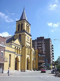
 Concepción (Tucumán): The City's Cathedral across from Mitre Square | |
| Coordinates: 27°20′S 65°35′W / 27.333°S 65.583°W | |
| Country | |
| Province | |
| Department | Chicligasta |
| Government | |
| • Mayor | Roberto Sanchez |
| Population (2010 census) | |
• Total | 49,782 |
| Demonym | concepcionense |
| Time zone | UTC-3 (ART) |
| CPA base | T4146 |
| Dialing code | +54 3865 |
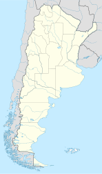
Concepción is a city and the department seat of Chicligasta in Tucumán Province, Argentina. It is located 76 km south of the provincial capital and largest city San Miguel de Tucumán and has a population of 49,782 (2010 census [INDEC]). Due to its population and bustling commercial activity, the city is considered to be the second most important urban area in the province (the first one being the Greater San Miguel de Tucumán region), and the main one in southern Tucumán.
-
Bartolomé Mitre Square.
-
Commercial district.
-
24 de Septiembre Street.
-
San Martín Avenue.
-
Courthouse (left) and local branch of the Banco Nación.
Wikimedia Commons has media related to Concepción, Tucumán.
References
[edit]


