Kfar Ahim: Difference between revisions
Appearance
Content deleted Content added
added Category:Polish-Jewish culture in Israel using HotCat |
rv POV editing |
||
| (25 intermediate revisions by 18 users not shown) | |||
| Line 1: | Line 1: | ||
{{Short description|Moshav in southern Israel}} |
|||
{{Infobox Kibbutz |
{{Infobox Kibbutz |
||
| name = Kfar Ahim |
| name = Kfar Ahim |
||
| hebname = {{Script/Hebrew|כְּפַר אַחִים}} |
|||
| foundation = 1949 |
| foundation = 1949 |
||
|image = |
| image = Kfar Ahim.jpg |
||
| founded_by = {{nowrap|[[Poland|Polish]] and [[Romania]]n [[Aliyah| |
| founded_by = {{nowrap|[[Poland|Polish]] and [[Romania]]n [[Aliyah|immigrants]]}} |
||
| country={{ISR}} |
|||
| district = south |
| district = south |
||
| council = [[Be'er Tuvia Regional Council|Be'er Tuvia]] |
| council = [[Be'er Tuvia Regional Council|Be'er Tuvia]] |
||
| Line 11: | Line 14: | ||
| population_footnotes={{Israel populations|reference}} |
| population_footnotes={{Israel populations|reference}} |
||
| pushpin_map = Israel ashkelon#Israel | pushpin_mapsize = 250 | pushpin_label_position = bottom |
| pushpin_map = Israel ashkelon#Israel | pushpin_mapsize = 250 | pushpin_label_position = bottom |
||
| coordinates = {{coord|31|44| |
| coordinates = {{coord|31|44|41|N|34|45|27|E|display=inline,title}} |
||
| meaning = Village of Brothers |
|||
| website = |
| website = |
||
}} |
}} |
||
'''Kfar Ahim''' ({{ |
'''Kfar Ahim''' ({{langx|he|כְּפַר אַחִים||Village of Brothers}}) is a [[moshav]] in south-central [[Israel]]. Located near [[Kiryat Malakhi]], it falls under the jurisdiction of [[Be'er Tuvia Regional Council]]. In {{Israel populations|Year}} it had a population of {{Israel populations|Kefar Ahim}}.{{Israel populations|reference}} |
||
==History== |
==History== |
||
The moshav was founded in 1949 by [[aliyah|Jewish immigrants]] from [[Poland]] and [[Romania]] on |
The moshav was founded in 1949 by [[aliyah|Jewish immigrants]] from [[Poland]] and [[Romania]] on land that had belonged to the depopulated [[Palestinian people|Palestinian]] village of [[Qastina]].<ref>{{cite book|title=All That Remains: The Palestinian Villages Occupied and Depopulated by Israel in 1948|url=https://books.google.com/books?id=_By7AAAAIAAJ |first1=Walid|last1=Khalidi|authorlink=Walid Khalidi|year=1992|location=[[Washington D.C.]]|publisher=[[Institute for Palestine Studies]]|isbn=0-88728-224-5|page=131 }}</ref> It was named for two brothers who were killed during the [[1948 Arab–Israeli War]], Zvi and Efraim Guber, sons of Mordecai and [[Rivka Guber]] from the nearby moshav of [[Kfar Warburg]].<ref name=mapa>{{Cite book |
||
| publisher = Mapa Publishing |
| publisher = Mapa Publishing |
||
| isbn = 965-7184-34-7 |
| isbn = 965-7184-34-7 |
||
| page = 282 |
| page = 282 |
||
| |
|editor-first=Yuval |editor-last=El'azari |
||
| title = Mapa's concise gazetteer of Israel |
| title = Mapa's concise gazetteer of Israel |
||
| location = Tel-Aviv |
| location = Tel-Aviv |
||
| Line 28: | Line 32: | ||
|language=he}}</ref> |
|language=he}}</ref> |
||
Notable natives of Kfar Ahim include [[Benny Gantz]] |
Notable natives of Kfar Ahim include politicians [[Benny Gantz]] and [[Israel Katz]]. |
||
==References== |
==References== |
||
{{ |
{{Reflist}} |
||
{{Be'er Tuvia Regional Council}} |
{{Be'er Tuvia Regional Council}} |
||
{{Authority control}} |
|||
[[Category:Moshavim]] |
[[Category:Moshavim]] |
||
| Line 40: | Line 45: | ||
[[Category:Populated places in Southern District (Israel)]] |
[[Category:Populated places in Southern District (Israel)]] |
||
[[Category:Polish-Jewish culture in Israel]] |
[[Category:Polish-Jewish culture in Israel]] |
||
[[Category:Romanian-Jewish culture in Israel]] |
|||
Latest revision as of 01:32, 27 November 2024
Kfar Ahim
כְּפַר אַחִים | |
|---|---|
 | |
| Etymology: Village of Brothers | |
| Coordinates: 31°44′41″N 34°45′27″E / 31.74472°N 34.75750°E | |
| Country | |
| District | Southern |
| Council | Be'er Tuvia |
| Affiliation | Moshavim Movement |
| Founded | 1949 |
| Founded by | Polish and Romanian immigrants |
| Population (2022)[1] | 861 |
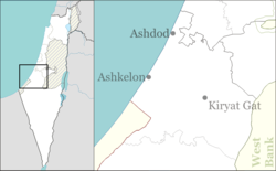
Kfar Ahim (Hebrew: כְּפַר אַחִים, lit. 'Village of Brothers') is a moshav in south-central Israel. Located near Kiryat Malakhi, it falls under the jurisdiction of Be'er Tuvia Regional Council. In 2022 it had a population of 861.[1]
History
[edit]The moshav was founded in 1949 by Jewish immigrants from Poland and Romania on land that had belonged to the depopulated Palestinian village of Qastina.[2] It was named for two brothers who were killed during the 1948 Arab–Israeli War, Zvi and Efraim Guber, sons of Mordecai and Rivka Guber from the nearby moshav of Kfar Warburg.[3]
Notable natives of Kfar Ahim include politicians Benny Gantz and Israel Katz.
References
[edit]- ^ a b "Regional Statistics". Israel Central Bureau of Statistics. Retrieved 21 March 2024.
- ^ Khalidi, Walid (1992). All That Remains: The Palestinian Villages Occupied and Depopulated by Israel in 1948. Washington D.C.: Institute for Palestine Studies. p. 131. ISBN 0-88728-224-5.
- ^ El'azari, Yuval, ed. (2005). Mapa's concise gazetteer of Israel (in Hebrew). Tel-Aviv: Mapa Publishing. p. 282. ISBN 965-7184-34-7.


