Bitgum: Difference between revisions
Appearance
Content deleted Content added
No edit summary |
Tom.Reding (talk | contribs) m WP:STUBSPACING followup |
||
| (7 intermediate revisions by 6 users not shown) | |||
| Line 19: | Line 19: | ||
| map_alt = |
| map_alt = |
||
| map_caption = Location in Menameradiel municipality |
| map_caption = Location in Menameradiel municipality |
||
| pushpin_map = Netherlands<!-- the name of a location map as per http://en.wikipedia.org/wiki/Template:Location_map --> |
| pushpin_map = Netherlands Friesland#Netherlands<!-- the name of a location map as per http://en.wikipedia.org/wiki/Template:Location_map --> |
||
| pushpin_label_position = right |
| pushpin_label_position = right |
||
| pushpin_mapsize = 250 |
| pushpin_mapsize = 250 |
||
| Line 27: | Line 27: | ||
| coordinates_footnotes = |
| coordinates_footnotes = |
||
| subdivision_type = Country |
| subdivision_type = Country |
||
| subdivision_name = |
| subdivision_name = [[Netherlands]] |
||
| subdivision_type1 = [[Provinces of the Netherlands|Province]] |
| subdivision_type1 = [[Provinces of the Netherlands|Province]] |
||
| subdivision_name1 = |
| subdivision_name1 = [[Friesland]] |
||
| subdivision_type2 = [[List of municipalities of the Netherlands|Municipality]] |
| subdivision_type2 = [[List of municipalities of the Netherlands|Municipality]] |
||
| subdivision_name2 = |
| subdivision_name2 = [[Waadhoeke]] |
||
| subdivision_type3 = |
| subdivision_type3 = |
||
| subdivision_name3 = |
| subdivision_name3 = |
||
| Line 45: | Line 45: | ||
| unit_pref = Metric |
| unit_pref = Metric |
||
<!-- ALL fields with measurements have automatic unit conversion --> |
<!-- ALL fields with measurements have automatic unit conversion --> |
||
<!-- for references: use <ref> tags -->| area_footnotes |
<!-- for references: use <ref> tags --> |
||
| area_footnotes = <ref name="stat"/> |
|||
| |
| area_total_km2 = 2.52 |
||
| elevation_footnotes = <ref name="AHN">{{cite web |url = http://www.ahn.nl/postcodetool |title = Postcodetool for 9044LA |language = nl |work = Actueel Hoogtebestand Nederland |publisher = Het Waterschapshuis |access-date = 4 April 2022 }}</ref> |
|||
| area_rural_footnotes = <!-- <ref> </ref> --> |
|||
| |
| elevation_m = 0.7 |
||
| |
| population_as_of = 2021 |
||
| population_footnotes = <ref name="stat">{{cite web |url=https://www.cbs.nl/-/media/_excel/2021/48/kwb-2021.xls |title=Kerncijfers wijken en buurten 2021 |website=Central Bureau of Statistics |access-date=4 April 2022}}</ref> |
|||
| area_note = |
|||
| |
| population_total = 800 |
||
| ⚫ | |||
| area_rank = |
|||
| |
| population_note = |
||
| ⚫ | |||
| area_blank2_title = <!-- square kilometers --> |
|||
| |
| timezone1 = |
||
| |
| utc_offset1 = |
||
| |
| timezone1_DST = |
||
| |
| utc_offset1_DST = |
||
| |
| timezone = [[Central European Time|CET]] |
||
| |
| utc_offset = +1 |
||
| |
| timezone_DST = [[Central European Summer Time|CEST]] |
||
| |
| utc_offset_DST = +2 |
||
| |
| postal_code_type = [[List of postal codes in the Netherlands|Postal code]] |
||
| |
| postal_code = 9044<ref name="stat"/> |
||
| |
| area_code_type = [[Telephone numbers in the Netherlands|Dialing code]] |
||
| |
| area_code = 058 |
||
| |
| iso_code = |
||
| |
| footnotes = |
||
| area_blank1_ha = |
|||
| area_blank2_ha = |
|||
| length_km = |
|||
| width_km = |
|||
| dimensions_footnotes = |
|||
| elevation_footnotes = |
|||
| elevation_m = |
|||
| population_as_of = 2017 |
|||
| population_footnotes = |
|||
| population_total = 792 |
|||
| ⚫ | |||
| population_note = |
|||
| ⚫ | |||
| timezone1 = [[Central European Time|CET]] |
|||
| utc_offset1 = +1 |
|||
| timezone1_DST = [[Central European Summer Time|CEST]] |
|||
| utc_offset1_DST = +2 |
|||
| postal_code_type = Postal code |
|||
| postal_code = 9044 |
|||
| area_code_type = Telephone area |
|||
| area_code = 058 |
|||
| iso_code = |
|||
| website = |
|||
| footnotes = |
|||
| official_name = |
|||
}} |
}} |
||
''' Bitgum ''' ({{ |
''' Bitgum ''' ({{langx|nl|Beetgum}}) is a village in [[Waadhoeke]] municipality in the province of [[Friesland]] in the [[Netherlands]]. It had a population of around 792 in January 2017.<ref>[https://www.menameradiel.nl/over-de-gemeente/feiten-en-cijfers.html Aantal inwoners per dorp] - Menameradiel</ref> |
||
==History== |
==History== |
||
Before 2018, the village was part of the [[Menameradiel]] municipality. Bitgum gained notoriety in 1895, when three brothers from the village |
Before 2018, the village was part of the [[Menameradiel]] municipality. Bitgum gained notoriety in 1895, when three brothers from the village (Keimpe, Wybren and Marten Hogerhuis) were arrested for their alleged and disputed involvement in a burglary in the village of [[Britsum]]. The involvement of the [[Sociaal_Democratische_Arbeiders_Partij|Social Democrat Party]]'s leader, [[Pieter Jelles Troelstra]] two years later, catapulted the village into the national headlines.<ref>[https://www.historischnieuwsblad.nl/nl/artikel/42335/de-gevangenis-in-door-klassenjustitie.html De gevangenis in door klassenjustitie] - Historisch Nieuwsblad {{in lang|nl}}</ref> |
||
| ⚫ | |||
| ⚫ | |||
== Gallery == |
|||
<gallery mode="packed"> |
<gallery mode="packed"> |
||
File:Beetgum, kerk foto2 2010-04-17 15.42.JPG|Church |
File:Beetgum, kerk foto2 2010-04-17 15.42.JPG|Church |
||
File:Hege Wier.jpg|Bitgum's "Hege Wier", remains of one of 5 |
File:Hege Wier.jpg|Bitgum's "Hege Wier", remains of one of 5 [[stins]], or medieval castles in Friesland |
||
</gallery> |
</gallery> |
||
| ⚫ | |||
| ⚫ | |||
==References== |
==References== |
||
| Line 111: | Line 89: | ||
{{Dutch municipality Waadhoeke}} |
{{Dutch municipality Waadhoeke}} |
||
{{Authority control}} |
|||
[[Category:Waadhoeke]] |
[[Category:Waadhoeke]] |
||
[[Category:Populated places in Friesland]] |
[[Category:Populated places in Friesland]] |
||
{{Friesland-geo-stub}} |
{{Friesland-geo-stub}} |
||
Latest revision as of 19:08, 28 November 2024
Bitgum | |
|---|---|
Village | |
 Bitgum | |
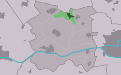
 Location in Menameradiel municipality | |
| Coordinates: 53°14′12″N 5°41′15″E / 53.23667°N 5.68750°E | |
| Country | Netherlands |
| Province | Friesland |
| Municipality | Waadhoeke |
| Area | |
• Total | 2.52 km2 (0.97 sq mi) |
| Elevation | 0.7 m (2.3 ft) |
| Population (2021)[1] | |
• Total | 800 |
| • Density | 320/km2 (820/sq mi) |
| Postal code | 9044[1] |
| Dialing code | 058 |
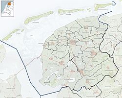
Bitgum (Dutch: Beetgum) is a village in Waadhoeke municipality in the province of Friesland in the Netherlands. It had a population of around 792 in January 2017.[3]
History
[edit]Before 2018, the village was part of the Menameradiel municipality. Bitgum gained notoriety in 1895, when three brothers from the village (Keimpe, Wybren and Marten Hogerhuis) were arrested for their alleged and disputed involvement in a burglary in the village of Britsum. The involvement of the Social Democrat Party's leader, Pieter Jelles Troelstra two years later, catapulted the village into the national headlines.[4]
Aircraft crash
[edit]On June 9, 2016, a demonstration fighter jet crashed in the lake next to 'De bodde', the pilot saved himself by ejecting from the aircraft.
Gallery
[edit]-
Church
-
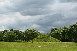
Bitgum's "Hege Wier", remains of one of 5 stins, or medieval castles in Friesland
References
[edit]- ^ a b c "Kerncijfers wijken en buurten 2021". Central Bureau of Statistics. Retrieved 4 April 2022.
- ^ "Postcodetool for 9044LA". Actueel Hoogtebestand Nederland (in Dutch). Het Waterschapshuis. Retrieved 4 April 2022.
- ^ Aantal inwoners per dorp - Menameradiel
- ^ De gevangenis in door klassenjustitie - Historisch Nieuwsblad (in Dutch)


