Margalef: Difference between revisions
Appearance
Content deleted Content added
{{For|the biologist|Ramon Margalef}} |
No edit summary |
||
| (35 intermediate revisions by 18 users not shown) | |||
| Line 2: | Line 2: | ||
{{Infobox settlement |
{{Infobox settlement |
||
<!-- See Template:Infobox settlement for additional fields and descriptions --> |
<!-- See Template:Infobox settlement for additional fields and descriptions --> |
||
| name = Margalef |
| name = Margalef |
||
| native_name = |
| native_name = |
||
| settlement_type = [[Municipalities of |
| settlement_type = [[Municipalities of Catalonia|Municipality]] |
||
| image_skyline = |
| image_skyline = margalef.jpg |
||
| image_alt = |
| image_alt = |
||
| image_caption = |
| image_caption = |
||
| image_flag = |
| image_flag = |
||
| flag_alt = |
| flag_alt = |
||
| image_seal = |
| image_seal = Escudo_de_Margalef_de_Montsant_(Tarragona).svg |
||
| seal_alt = |
| seal_alt = |
||
| image_shield = |
| image_shield = |
||
| Line 23: | Line 23: | ||
| pushpin_map_alt = |
| pushpin_map_alt = |
||
| pushpin_map_caption = Location in Catalonia |
| pushpin_map_caption = Location in Catalonia |
||
| coordinates = {{coord|41|17|7|N|0|45|15|E|display=inline,title}} |
|||
| latd = 41|latm = 17|lats = 7|latNS = N |
|||
| longd = 0|longm = 45|longs = 15|longEW = E |
|||
| coor_pinpoint = |
| coor_pinpoint = |
||
| coordinates_type = |
|||
| coordinates_display = inline,title |
|||
| coordinates_footnotes = |
| coordinates_footnotes = |
||
| subdivision_type = [[List of sovereign states|Country]] |
| subdivision_type = [[List of sovereign states|Country]] |
||
| Line 34: | Line 31: | ||
| subdivision_name1 = {{flag|Catalonia}} |
| subdivision_name1 = {{flag|Catalonia}} |
||
| subdivision_type2 = [[Provinces of Spain|Province]] |
| subdivision_type2 = [[Provinces of Spain|Province]] |
||
| subdivision_name2 = [[Tarragona]] |
| subdivision_name2 = [[Province of Tarragona|Tarragona]] |
||
| subdivision_type3 = [[Comarques of Catalonia|Comarca]] |
| subdivision_type3 = [[Comarques of Catalonia|Comarca]] |
||
| subdivision_name3 = [[Priorat]] |
| subdivision_name3 = [[Priorat]] |
||
| Line 44: | Line 41: | ||
| government_footnotes = |
| government_footnotes = |
||
| leader_party = |
| leader_party = |
||
| leader_title = |
| leader_title = mayor |
||
| leader_name = Joaquim Vila Gibert (2015)<ref name=municat>{{cite web|url=http://aplicacions.municat.gencat.cat/index.php?page=consulta&mostraEns=4307510007|title=Ajuntament de Margalef|publisher=[[Generalitat of Catalonia]]|access-date=2015-11-13}}</ref> |
|||
| leader_name = |
|||
| unit_pref = Metric<!-- or US or UK --> |
| unit_pref = Metric<!-- or US or UK --> |
||
| area_footnotes = <ref name=idescat>{{cite web|url=http://www.idescat.cat/emex/?lang=en&id=430751|title=El municipi en xifres: Margalef|publisher=[[Institut d'Estadística de Catalunya|Statistical Institute of Catalonia]]|access-date=2015-11-23}}</ref> |
|||
| area_footnotes = |
|||
| area_total_km2 = |
| area_total_km2 = 34.7 |
||
| area_land_km2 = |
| area_land_km2 = |
||
| area_water_km2 = |
| area_water_km2 = |
||
| Line 55: | Line 52: | ||
| elevation_footnotes = |
| elevation_footnotes = |
||
| elevation_m = 379 |
| elevation_m = 379 |
||
| population_as_of = {{Spain metadata Wikidata|population_as_of}} |
|||
| population_footnotes = |
|||
| population_footnotes = {{Spain metadata Wikidata|population_footnotes}} |
|||
| population_total = |
|||
| population_total = {{Spain metadata Wikidata|population_total}} |
|||
| population_as_of = |
|||
| population_density_km2 = auto |
| population_density_km2 = auto |
||
| population_demonym = Margalefà, margalefana |
| population_demonym = Margalefà, margalefana |
||
| population_note = |
| population_note = |
||
| timezone1 = [[Central European Time|CET]] |
|||
| utc_offset1 = +1 |
|||
| timezone1_DST = [[Central European Summer Time|CEST]] |
|||
| utc_offset1_DST = +2 |
|||
| postal_code_type = |
| postal_code_type = |
||
| postal_code = |
| postal_code = |
||
| Line 70: | Line 63: | ||
| area_code = |
| area_code = |
||
| iso_code = |
| iso_code = |
||
| website = |
| website = {{URL|margalef.org}} |
||
| footnotes = |
| footnotes = |
||
}} |
}} |
||
| Line 77: | Line 70: | ||
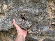
[[File:Margalef rock climbing.jpg|thumb |alt=Climbing at Margalef|''Forat'' hold on a Conglomerate rock in Margalef]] |
[[File:Margalef rock climbing.jpg|thumb |alt=Climbing at Margalef|''Forat'' hold on a Conglomerate rock in Margalef]] |
||
'''Margalef''' is a village in [[Catalonia]], |
'''Margalef''' ({{IPA|ca|maɾɣaˈlɛf}}) is a village in [[Catalonia]], Spain. It is situated on the edge of [[Serra de Montsant|Montsant]] and is a popular [[ecotourism]] destination, especially among [[rock climbing|rock climbers]]. The rock type is [[Conglomerate (geology)|conglomerate]] and it has more than 1500 climbing routes of different grades, from 4 to 9b+. Many of the buildings in the village are also built on conglomerate formations. |
||
Margalef's important economic activity is agriculture, mainly producing [[olive]]s, [[almond]]s, and fruits. |
Margalef's important economic activity is agriculture, mainly producing [[olive]]s, [[almond]]s, and fruits. |
||
==References== |
|||
{{reflist}} |
|||
==External links== |
==External links== |
||
* Official site |
* {{Official site|1=http://www.margalef.altanet.org/en_index.php}} |
||
* [http://aplicacions.municat.gencat.cat/index.php?page=consulta&mostraEns=4307510007 Government data pages] {{in lang|ca}} |
|||
* http://www.planetmountain.com/english/rock/crags/falesia.html?idfalesia=106 |
|||
* http:// |
* [http://margalefclimb.com All about rock climbing in Margalef] |
||
{{br}} |
|||
{{Geographic location |
{{Geographic location |
||
|Centre = Margalef |
|Centre = Margalef |
||
| Line 94: | Line 89: | ||
|SE = [[La Morera de Montsant]] |
|SE = [[La Morera de Montsant]] |
||
|S = [[Cabacés]] |
|S = [[Cabacés]] |
||
|SW = [[La Bisbal de |
|SW = [[La Bisbal de Montsant]] |
||
|W = [[Flix]] |
|W = [[Flix, Spain|Flix]] |
||
|NW = [[Bellaguarda]] |
|NW = [[Bellaguarda]] |
||
}} |
}} |
||
{{Priorat}} |
|||
{{Municipalities in Tarragona|state=autocollapse}} |
{{Municipalities in Tarragona|state=autocollapse}} |
||
{{Authority control}} |
|||
[[Category:Municipalities in |
[[Category:Municipalities in Priorat]] |
||
| ⚫ | |||
[[Category:Climbing areas of Spain]] |
[[Category:Climbing areas of Spain]] |
||
| ⚫ | |||
{{Tarragona-geo-stub}} |
|||
Latest revision as of 13:04, 29 November 2024
Margalef | |
|---|---|
 | |
| Coordinates: 41°17′7″N 0°45′15″E / 41.28528°N 0.75417°E | |
| Country | |
| Autonomous community | |
| Province | Tarragona |
| Comarca | Priorat |
| Government | |
| • mayor | Joaquim Vila Gibert (2015)[1] |
| Area | |
• Total | 34.7 km2 (13.4 sq mi) |
| Elevation | 379 m (1,243 ft) |
| Population (2018)[3] | |
• Total | 94 |
| • Density | 2.7/km2 (7.0/sq mi) |
| Demonym(s) | Margalefà, margalefana |
| Website | margalef |


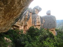
Margalef (Catalan pronunciation: [maɾɣaˈlɛf]) is a village in Catalonia, Spain. It is situated on the edge of Montsant and is a popular ecotourism destination, especially among rock climbers. The rock type is conglomerate and it has more than 1500 climbing routes of different grades, from 4 to 9b+. Many of the buildings in the village are also built on conglomerate formations.
Margalef's important economic activity is agriculture, mainly producing olives, almonds, and fruits.
References
[edit]- ^ "Ajuntament de Margalef". Generalitat of Catalonia. Retrieved 2015-11-13.
- ^ "El municipi en xifres: Margalef". Statistical Institute of Catalonia. Retrieved 2015-11-23.
- ^ Municipal Register of Spain 2018. National Statistics Institute.
External links
[edit]


