Veldenz: Difference between revisions
Updated Arms to latest version, much clearer and sharper |
m use wikitable |
||
| (39 intermediate revisions by 26 users not shown) | |||
| Line 1: | Line 1: | ||
{{Infobox German |
{{Infobox German place |
||
|image_photo = |
|image_photo = Veldenz 2019.jpg |
||
|image_caption = The village of Veldenz as seen from [[Schloss Veldenz|Veldenz Castle]] |
|||
|Wappen = Wappen Veldenz.svg |
|||
| |
|image_coa = Wappen Veldenz.svg |
||
|coordinates = {{coord|49|53|26|N|7|1|33|E|format=dms|display=inline,title}} |
|||
|lon_deg = 7 |lon_min = 1 |lon_sec = 33 |
|||
|image_plan = Veldenz in WIL.svg |
|||
|Lageplan = |
|||
| |
|state = Rheinland-Pfalz |
||
| |
|district = Bernkastel-Wittlich |
||
|Verbandsgemeinde = Bernkastel-Kues |
|Verbandsgemeinde = Bernkastel-Kues |
||
| |
|elevation = 170 |
||
| |
|area = 14.41 |
||
| |
|postal_code = 54472 |
||
| |
|area_code = 06534 |
||
| |
|licence = WIL |
||
|Vorwahl = 06534 |
|||
|Kfz = WIL |
|||
|Gemeindeschlüssel = 07 2 31 126 |
|Gemeindeschlüssel = 07 2 31 126 |
||
| |
|divisions = 2 |
||
|website = [http://www.veldenz.de//tools/internet/view.php?rID=2&TabellenName=katalog1&SpracheChange=1 www.veldenz.de] |
|||
|Adresse-Verband = Gestade 18<br>54470 Bernkastel-Kues |
|||
|mayor = Norbert Sproß<ref>[https://www.wahlen.rlp.de/de/kw/wahlen/kd/gebiete/2310000000000.html Direktwahlen 2019, Landkreis Bernkastel-Wittlich], Landeswahlleiter Rheinland-Pfalz, accessed 6 August 2021.</ref> |
|||
|Website = [http://www.veldenz.de//tools/internet/view.php?rID=2&TabellenName=katalog1&SpracheChange=1 www.veldenz.de] |
|||
|leader_term = 2019–24 |
|||
|Bürgermeister = Norbert Sproß |
|||
}} |
}} |
||
[[File:Veldenz 2007.jpg|thumb|upright=1.3|Veldenz valley is a dry fallen [[meander]] of the river [[Moselle]]. The village to the left and [[Geisberg (Middle Moselle)|Geisberg]] mountain to the right.]] |
|||
'''Veldenz''' is a municipality in the [[Bernkastel-Wittlich|district |
'''Veldenz''' is an ''Ortsgemeinde'' – a [[Municipalities of Germany|municipality]] belonging to a ''[[Verbandsgemeinde]]'', a kind of collective municipality – in the [[Bernkastel-Wittlich]] [[Districts of Germany|district]] in [[Rhineland-Palatinate]], [[Germany]]. It is the former main seat of the [[County of Veldenz]], once a prominent principality to which belonged 120 villages and towns now in Rhineland-Palatinate and northern [[Alsace]] and [[Lorraine]]. |
||
__toc__ |
|||
<br style="clear:left" /> |
|||
== Geography == |
== Geography == |
||
=== Location === |
=== Location === |
||
The municipality lies in the [[Mittelmosel]] region |
The municipality lies in the [[Mittelmosel|Middle Moselle]] region of valley country marked by even slopes and former oxbows of the [[Moselle (river)|Moselle]]. Veldenz is found on the Moselle's right bank, but does not lie right at the water's edge, but rather some two kilometres back from the river, under the outermost forests of the [[Hunsrück]]. Roughly 850 ha of the 1 441 ha municipal area is wooded. About 130 ha is given over to [[winegrowing]]. |
||
Veldenz belongs to the [[Bernkastel-Kues (Verbandsgemeinde)|''Verbandsgemeinde'' of Bernkastel-Kues]], whose seat is in the [[Bernkastel-Kues|like-named town]]. |
|||
=== Neighbourhood === |
|||
Veldenz has two divisions, Veldenz and Thalveldenz. Neighbouring municipalities are [[Burgen, Bernkastel-Wittlich|Burgen]] and [[Mülheim an der Mosel|Mülheim]]. The nearest main towns are [[Bernkastel-Kues]], about ten kilometres away, and [[Wittlich]], about 17 kilometres away. [[Trier]] is approximately 45 kilometres distant. |
|||
=== |
=== Nearby municipalities === |
||
Neighbouring municipalities are, among others, [[Burgen, Bernkastel-Wittlich|Burgen]] and [[Mülheim an der Mosel|Mülheim]]. The nearest [[Central place theory|middle centres]] are [[Bernkastel-Kues]], some 10 km away, and [[Wittlich]], some 17 km away. [[Trier]] lies some 45 km away. |
|||
Veldenz lies within the [[temperate]] region; relative to other regions of Germany it has a very warm and sunny climate - in neighbouring [[Brauneberg]] on the 11. August 1998 [[Jörg Kachelmann]]'s [[Meteomedia AG|Meteomedia]] [[Weather station]] recorded the highest ever measured German [[air temperature]] of 41.2°C. (This is not regarded as a German record since the weather-station is excluded from the official measurements on the basis of its location on a slate-mountain). Due to Veldenz’s situation in the lee of the [[Eifel]] range rain is common in the Northwest. Evaporation from the nearby Mosel leads to regular high [[humidity]], especially in the summer and is a partial cause of close weather and thunderstorms. |
|||
=== Constituent communities === |
|||
Veldenz's ''[[Ortsteil]]e'' are Veldenz and Thalveldenz. |
|||
=== Climate === |
|||
Veldenz lies within the [[Temperateness|temperate zone]]; compared to other regions in Germany, a very warm and sunny climate prevails here. In neighbouring [[Brauneberg]] on 11 August 1998, a record temperature of 41.2 °C in the shade, the highest ever air temperature recorded in the Federal Republic, was confirmed. Because of its location alee of the [[Eifel]], [[Precipitation (meteorology)|precipitation]] from northwest weather systems is often kept away. Ongoing evaporation of water from the [[Moselle (river)|Moselle]] regularly leads to high humidity, which, especially in summer, makes at times for heavy and muggy weather, and which also brings many storms along with it. |
|||
== History == |
== History == |
||
As early as 500 BC, the [[Treveri]], a people of mixed [[Celts|Celtic]] and [[Germanic peoples|Germanic]] stock, from whom the [[Latin]] name for the city of [[Trier]], ''[[History of Trier|Augusta Treverorum]]'', is also derived, settled in Veldenz's fertile valley. After them, from about 50 BC to AD 500 came the [[Ancient Rome|Romans]]. Possibly about the year 1129, Gerlach I built a castle, today's [[Schloss Veldenz]]. In 1286, [[Rudolph I of Germany|Rudolph of Habsburg]] granted Veldenz town and market rights. By 1444, the castle and its environs had passed to [[Stephen, Count Palatine of Simmern-Zweibrücken]], or between 1543 and 1694 the Principality of [[County of Veldenz#Palantine Veldenz Line|Palatinate-Veldenz]]. In 1752, in [[Burgen, Bernkastel-Wittlich|Burgen]] near Veldenz, the widely known robber, [[Johann Peter Petri]], also known as ''Schwarzer Peter'' (“Black Peter”), was born. From 1777 to 1797, Veldenz belonged to [[Bavaria]]. After French rule as part of [[Sarre (department)|Sarre]] department, it was annexed to [[Prussia]] in 1815. In 1835 the Veldenz Lion was adopted as the Bavarian Lion in that kingdom's coat of arms. Even today, many examples of comital building undertakings from the 18th century can be found, among them the town hall. |
|||
== Politics == |
== Politics == |
||
<!--[[File:Bevoelkerung Veldenz.png|thumb|Population development of the ''Ortsgemeinde'' of Veldenz]]--> |
|||
Veldenz is a member of the [[Bernkastel-Kues]] [[Verbandsgemeinde]]. Political responsibility and twelve seats in the local council is divided between two constituencies. The mayor of the local community is Norbert Sproß. |
|||
[[Image:Bayerisches Staatswappen 1835.png|thumb|Bavarian Arms of 1835 with the Veldenz Lion. It also shows: the Pfälz Lion, the Frankish Rake and Margraveate of Burgau also the central shield contains the Bavarian diamonds. This coat of arms lapsed at the end of the monarchy.]] |
|||
=== Municipal council === |
|||
Result of the Local Elections 13. June 2004: |
|||
The council is made up of 12 council members, who were elected at the municipal election held on 7 June 2009. The mayor is Norbert Sproß. |
|||
{| border="1" cellspacing="0" cellpadding="3" style="border-collapse:collapse;" |
|||
[[File:Bayerisches Staatswappen 1835.png|thumb|180px|right|Bavarian coat of arms from 1835 with the Lion of Veldenz. It also depicts: the [[Palatine Lion]], the Franconian Rake and the Margraviate of Burgau as well as the Bavarian lozenges in the inescutcheon. These arms held their place until the end of the monarchy.]] |
|||
! width=155px | |
|||
! width=49px align="center" style="background:#CFCFCF"| Number |
|||
The municipal election held on 7 June 2009 yielded the following results: |
|||
! width=49px align="center" style="background:#CFCFCF"| Per cent |
|||
{| class="wikitable" width="400" |
|||
! width=49px align="center" style="background:#CFCFCF"| Seats |
|||
! Year || Freie Wählergruppe Veldenz e.V. || Freie Wählergruppe Bauer || Total |
|||
|- |
|||
|- align="center" |
|||
| style="background:#CFCFCF" |Voters |
|||
| 2009 || 7 || 5 || 12 seats |
|||
| align="right" | 749 |
|||
| align="right" | 100,0 |
|||
| align="right" | 12 |
|||
|- |
|||
| style="background:#CFCFCF" |Votes Cast |
|||
| align="right" | 501 |
|||
| align="right" | 66,9 |
|||
| align="right" | |
|||
|- |
|||
| style="background:#CFCFCF" |Spoilt Papers |
|||
| align="right" | 21 |
|||
| align="right" | 4,2 |
|||
| align="right" | |
|||
|- |
|||
| style="background:#CFCFCF" |Valid Papers |
|||
| align="right" | 480 |
|||
| align="right" | 95,8 |
|||
| align="right" | |
|||
|- |
|||
| colspan="4" style="background:#CFCFCF" height=1px| |
|||
|- |
|||
| style="background:#E1E1E1" |Election Group 1 |
|||
| align="right" | 316 |
|||
| align="right" | 65,8 |
|||
| align="right" | 8 |
|||
|- |
|||
| style="background:#E1E1E1" |Election Group 2 |
|||
| align="right" | 164 |
|||
| align="right" | 34,2 |
|||
| align="right" | 4 |
|||
|} |
|} |
||
=== |
=== Coat of arms === |
||
[[File:Wappen Veldenz.svg|left|70px| |
[[File:Wappen Veldenz.svg|left|70px|Coat of arms of Veldenz]] |
||
The municipality's [[Coat of arms|arms]] might be described thus: Bendy lozengy argent and azure, in dexter chief an inescutcheon of the first charged with a lion rampant of the second armed and langued gules. |
|||
The coat of arms shows the [[Veldenz lion|Veldenz Lion]] and the [[Wittelsbach]] diamonds. In the year 1835 the lion of the [[Ludwig I of Bavaria|King of Bavaria]] was placed on the arms, and remained there until the end of the [[First World War]] when the last Bavarian king [[Ludwig III of Bavaria|Ludwig III]] abdicated during the [[German Revolution|November Revolution]]. |
|||
The lion in the [[inescutcheon]] is the heraldic [[charge (heraldry)|charge]] once borne by the [[County of Veldenz|Counts of Veldenz]], and the “bendy lozengy” pattern seen on the field is the [[House of Wittelsbach|Wittelsbach dynasty's]] armorial bearing. In 1835, this lion was adopted by [[Ludwig I of Bavaria|Ludwig I, King of Bavaria]] into that kingdom's state coat of arms, where it remained as a charge until the end of the [[First World War]] when the last Bavarian king, [[Ludwig III of Bavaria|Ludwig III]] was forced to abdicate as a result of the [[German Revolution of 1918–19|November Revolution]]. |
|||
== Culture and Sights == |
|||
=== Village Life === |
|||
In 1993 and 1995 Veldenz won the silver medal in the Federal Beautiful Village Competition. In the Elisenberg, Kirchberg, Mühlberg, Grafschafter Sonnenberg and Carlsberg there are vineyards. In the village, there are still about a dozen [[Winery|wineries]], [[Riesling]] is the most common variety. There is also a Heritage Association, which continues the old customs, holds home evenings and village walks. There is a Men's Singing Club, a women's choir and a folk music orchestra, who are all involved in the conduct of public events. Veldenz has a volunteer fire brigade and a sports club. |
|||
== Culture and sightseeing == |
|||
=== Sights === |
|||
Well known sights are the ''Villa Romana'' and [[Schloss Veldenz]]. There are other historical buildings such as the [[Rathaus]], a 12th Century signal tower from the, a [[Mint (coin)|Mint]], a Celtic Wall and several museums with exhibitions. Other attractions are a second hand market, a farm garden, a wild garden, the Josefine Heights, the Pioneer Rocks, and many ore and slate mines, the Roter Bohles Recreation Park and many impressive rock formations. |
|||
=== |
=== Village culture === |
||
In 1993 and 1995, Veldenz won the silver medal of the Federal Republic in the contest ''Unser Dorf soll schöner werden'' (“Our village should become lovelier”); in 2006, the villagers managed to triumph once again in the district and regional contest. In the vineyard locations of Elisenberg, Kirchberg, Mühlberg, Grafschafter Sonnenberg and Carlsberg, there is [[winegrowing]]. There still exist today in the municipality about a dozen wineries; [[Riesling]] is the customary variety. |
|||
Veldenz regularly holds a Heritage and Wine festival, a City Hall celebration, an Oktoberfest and a [[Christmas market]]. Also [[concert (music event)|Concert]]s as part of the [[Mosel Festwochen|Mosel Festival Week]]. The Community organises an annual [[Arts and Crafts market]]. |
|||
=== Sightseeing === |
|||
In nearby [[Bernkastel-Kues]] the [[Middle Mosel Wine Festival]], one of the largest wine festivals of the Moselle take place annually, in which Veldez participates. |
|||
[[File:Schloss-veldenz-okt-2007.jpg|thumb|Schloss Veldenz 2007]] |
|||
Well known points of interest are the ''Villa Romana'' and [[Schloss Veldenz]]. There are other monumental buildings, such as the town hall, a signal tower from the 12th century, a mint, a Celtic wall and museums with various exhibits. Further points of interest are an historical market (''Krammarkt''), a farmer's garden (''Bauerngarten''), a wild garden, the ''Josefinenhöhe'' (heights), the ''Pionierfelsen'' (cliff), many ore and slate mines, the ''Roter Bohles'' leisure complex and many imposing cliff formations. |
|||
==Economy and |
== Economy and infrastructure == |
||
[[Winegrowing]] and [[ |
[[Winegrowing]] and [[tourism]] play a prominent rôle. In Veldenz there are two village squares, three community houses, a village hall, several barbecue pits, educational paths dealing with both wine and the forest, a memorial, a graveyard, two churches and a sporting ground. Furthermore, Veldenz also has its own [[primary school]], a [[kindergarten]], a youth centre, a [[Association football|football]] field and four children's playgrounds. In the village is also a regional children's and youth home. Roughly 45 km of hiking trails lead around the village. Public transport in Veldenz is integrated into the ''Verkehrsverbund Region Trier'' (VRT), whose fares therefore apply. |
||
== Further reading == |
|||
* Ernst Probst: ''Der Schwarze Peter. Ein Räuber im Hunsrück und Odenwald.'' Probst, Mainz-Kostheim 2005, {{ISBN|3-936326-39-8}} |
|||
* Theodor Gümbel: ''Geschichte des Fürstentums Pfalz-Veldenz.'' E. Grusius, Kaiserslautern 1900. |
|||
== References == |
|||
{{reflist}} |
|||
== External links == |
== External links == |
||
{{commons category|Veldenz}} |
|||
* [http://www.veldenz.de//tools/internet/view.php?rID=2&TabellenName=katalog1&SpracheChange=1 Official Internet pages] German |
|||
* [https://web.archive.org/web/20070526161253/http://www.veldenz.de/tools/internet/view.php?rID=2&TabellenName=katalog1&SpracheChange=1 Municipality’s official webpage] |
|||
* [http://www.schlossveldenz.com/ Schloss Veldenz] |
* [http://www.schlossveldenz.com/ Schloss Veldenz] |
||
* [http://www.sv-veldenz.de/ Sportverein Veldenz] (sport club) |
|||
{{Cities and towns in Bernkastel-Wittlich (district)}} |
{{Cities and towns in Bernkastel-Wittlich (district)}} |
||
{{Authority control}} |
|||
[[de:Veldenz]] |
|||
[[eo:Veldenz]] |
|||
[[Category:Bernkastel-Wittlich]] |
|||
[[fr:Veldenz]] |
|||
[[nl:Veldenz]] |
|||
[[ro:Veldenz]] |
|||
[[ru:Фельденц]] |
|||
[[vo:Veldenz]] |
|||
Latest revision as of 08:50, 30 November 2024
Veldenz | |
|---|---|
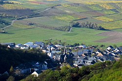
 The village of Veldenz as seen from Veldenz Castle | |
| Coordinates: 49°53′26″N 7°1′33″E / 49.89056°N 7.02583°E | |
| Country | Germany |
| State | Rhineland-Palatinate |
| District | Bernkastel-Wittlich |
| Municipal assoc. | Bernkastel-Kues |
| Subdivisions | 2 |
| Government | |
| • Mayor (2019–24) | Norbert Sproß[1] |
| Area | |
• Total | 14.41 km2 (5.56 sq mi) |
| Elevation | 170 m (560 ft) |
| Population (2022-12-31)[2] | |
• Total | 956 |
| • Density | 66/km2 (170/sq mi) |
| Time zone | UTC+01:00 (CET) |
| • Summer (DST) | UTC+02:00 (CEST) |
| Postal codes | 54472 |
| Dialling codes | 06534 |
| Vehicle registration | WIL |
| Website | www.veldenz.de |

Veldenz is an Ortsgemeinde – a municipality belonging to a Verbandsgemeinde, a kind of collective municipality – in the Bernkastel-Wittlich district in Rhineland-Palatinate, Germany. It is the former main seat of the County of Veldenz, once a prominent principality to which belonged 120 villages and towns now in Rhineland-Palatinate and northern Alsace and Lorraine.
Geography
[edit]Location
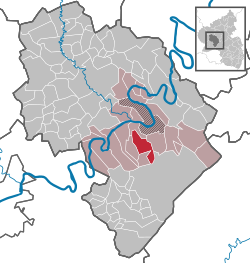
[edit]The municipality lies in the Middle Moselle region of valley country marked by even slopes and former oxbows of the Moselle. Veldenz is found on the Moselle's right bank, but does not lie right at the water's edge, but rather some two kilometres back from the river, under the outermost forests of the Hunsrück. Roughly 850 ha of the 1 441 ha municipal area is wooded. About 130 ha is given over to winegrowing.
Veldenz belongs to the Verbandsgemeinde of Bernkastel-Kues, whose seat is in the like-named town.
Nearby municipalities
[edit]Neighbouring municipalities are, among others, Burgen and Mülheim. The nearest middle centres are Bernkastel-Kues, some 10 km away, and Wittlich, some 17 km away. Trier lies some 45 km away.
Constituent communities
[edit]Veldenz's Ortsteile are Veldenz and Thalveldenz.
Climate
[edit]Veldenz lies within the temperate zone; compared to other regions in Germany, a very warm and sunny climate prevails here. In neighbouring Brauneberg on 11 August 1998, a record temperature of 41.2 °C in the shade, the highest ever air temperature recorded in the Federal Republic, was confirmed. Because of its location alee of the Eifel, precipitation from northwest weather systems is often kept away. Ongoing evaporation of water from the Moselle regularly leads to high humidity, which, especially in summer, makes at times for heavy and muggy weather, and which also brings many storms along with it.
History
[edit]As early as 500 BC, the Treveri, a people of mixed Celtic and Germanic stock, from whom the Latin name for the city of Trier, Augusta Treverorum, is also derived, settled in Veldenz's fertile valley. After them, from about 50 BC to AD 500 came the Romans. Possibly about the year 1129, Gerlach I built a castle, today's Schloss Veldenz. In 1286, Rudolph of Habsburg granted Veldenz town and market rights. By 1444, the castle and its environs had passed to Stephen, Count Palatine of Simmern-Zweibrücken, or between 1543 and 1694 the Principality of Palatinate-Veldenz. In 1752, in Burgen near Veldenz, the widely known robber, Johann Peter Petri, also known as Schwarzer Peter (“Black Peter”), was born. From 1777 to 1797, Veldenz belonged to Bavaria. After French rule as part of Sarre department, it was annexed to Prussia in 1815. In 1835 the Veldenz Lion was adopted as the Bavarian Lion in that kingdom's coat of arms. Even today, many examples of comital building undertakings from the 18th century can be found, among them the town hall.
Politics
[edit]Municipal council
[edit]The council is made up of 12 council members, who were elected at the municipal election held on 7 June 2009. The mayor is Norbert Sproß.

The municipal election held on 7 June 2009 yielded the following results:
| Year | Freie Wählergruppe Veldenz e.V. | Freie Wählergruppe Bauer | Total |
|---|---|---|---|
| 2009 | 7 | 5 | 12 seats |
Coat of arms
[edit]
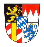
The municipality's arms might be described thus: Bendy lozengy argent and azure, in dexter chief an inescutcheon of the first charged with a lion rampant of the second armed and langued gules.
The lion in the inescutcheon is the heraldic charge once borne by the Counts of Veldenz, and the “bendy lozengy” pattern seen on the field is the Wittelsbach dynasty's armorial bearing. In 1835, this lion was adopted by Ludwig I, King of Bavaria into that kingdom's state coat of arms, where it remained as a charge until the end of the First World War when the last Bavarian king, Ludwig III was forced to abdicate as a result of the November Revolution.
Culture and sightseeing
[edit]Village culture
[edit]In 1993 and 1995, Veldenz won the silver medal of the Federal Republic in the contest Unser Dorf soll schöner werden (“Our village should become lovelier”); in 2006, the villagers managed to triumph once again in the district and regional contest. In the vineyard locations of Elisenberg, Kirchberg, Mühlberg, Grafschafter Sonnenberg and Carlsberg, there is winegrowing. There still exist today in the municipality about a dozen wineries; Riesling is the customary variety.
Sightseeing
[edit]
Well known points of interest are the Villa Romana and Schloss Veldenz. There are other monumental buildings, such as the town hall, a signal tower from the 12th century, a mint, a Celtic wall and museums with various exhibits. Further points of interest are an historical market (Krammarkt), a farmer's garden (Bauerngarten), a wild garden, the Josefinenhöhe (heights), the Pionierfelsen (cliff), many ore and slate mines, the Roter Bohles leisure complex and many imposing cliff formations.
Economy and infrastructure
[edit]Winegrowing and tourism play a prominent rôle. In Veldenz there are two village squares, three community houses, a village hall, several barbecue pits, educational paths dealing with both wine and the forest, a memorial, a graveyard, two churches and a sporting ground. Furthermore, Veldenz also has its own primary school, a kindergarten, a youth centre, a football field and four children's playgrounds. In the village is also a regional children's and youth home. Roughly 45 km of hiking trails lead around the village. Public transport in Veldenz is integrated into the Verkehrsverbund Region Trier (VRT), whose fares therefore apply.
Further reading
[edit]- Ernst Probst: Der Schwarze Peter. Ein Räuber im Hunsrück und Odenwald. Probst, Mainz-Kostheim 2005, ISBN 3-936326-39-8
- Theodor Gümbel: Geschichte des Fürstentums Pfalz-Veldenz. E. Grusius, Kaiserslautern 1900.
References
[edit]- ^ Direktwahlen 2019, Landkreis Bernkastel-Wittlich, Landeswahlleiter Rheinland-Pfalz, accessed 6 August 2021.
- ^ "Bevölkerungsstand 2022, Kreise, Gemeinden, Verbandsgemeinden" (PDF) (in German). Statistisches Landesamt Rheinland-Pfalz. 2023.


