Le Château, Saint Barthélemy: Difference between revisions
Appearance
Content deleted Content added
Dr. Blofeld (talk | contribs) No edit summary |
BigBullfrog (talk | contribs) No edit summary |
||
| (6 intermediate revisions by 6 users not shown) | |||
| Line 1: | Line 1: | ||
{{Infobox settlement |
{{Infobox settlement |
||
|name = Le Château |
|name = Le Château |
||
|other_name = |
|other_name = |
||
|native_name = |
|native_name = |
||
|settlement_type =''Quartier'' |
|settlement_type = ''Quartier'' |
||
|image_skyline = |
|image_skyline = |
||
|imagesize = |
|imagesize = |
||
|image_caption = |
|image_caption = |
||
| |
|image_map = Saint-Barthélemy quartiers map.svg |
||
| |
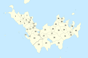
|map_caption = The quartier of Le Château, Saint Barthélemy marked 14. |
||
|mapsize=300px |
|mapsize = 300px |
||
|pushpin_map = |
|pushpin_map = |
||
|pushpin_label_position = |
|pushpin_label_position = |
||
|pushpin_map_caption = |
|pushpin_map_caption = |
||
| |
|coordinates = {{coord|17|54|22|N|62|50|29|W|region:BL|display=inline,title}} |
||
|coordinates_region = |
|||
|subdivision_type = [[List of sovereign states|Country]] |
|subdivision_type = [[List of sovereign states|Country]] |
||
|subdivision_name ={{flag|France}} |
|subdivision_name = {{flag|France}} |
||
|subdivision_type1 =[[Overseas collectivity]] |
|subdivision_type1 = [[Overseas collectivity]] |
||
|subdivision_name1 =[[File:Blason St Barthélémy TOM entire.svg|23px]] [[Saint Barthélemy]] |
|subdivision_name1 = [[File:Blason St Barthélémy TOM entire.svg|23px]] [[Saint Barthélemy]] |
||
|leader_title = |
|leader_title = |
||
|leader_name = |
|leader_name = |
||
|established_title = |
|established_title = |
||
|established_date = |
|established_date = |
||
|area_total_km2 |
|area_total_km2 = |
||
|population_as_of |
|population_as_of = |
||
|population_footnotes |
|population_footnotes = |
||
|population_total |
|population_total = |
||
|population_density_km2 |
|population_density_km2 = |
||
|timezone = |
|timezone = |
||
|utc_offset = |
|utc_offset = |
||
|latd=17|latm=54|lats=22|latNS=N |
|||
|longd=62 |longm=50|longs=29|longEW=W |
|||
|elevation_footnotes = |
|elevation_footnotes = |
||
|elevation_m = |
|elevation_m = |
||
| Line 37: | Line 34: | ||
|website = |
|website = |
||
|footnotes = |
|footnotes = |
||
}} |
}} |
||
| ⚫ | |||
| ⚫ | |||
| ⚫ | |||
==See also== |
|||
* [[Gustaf III Airport]] |
|||
{{DEFAULTSORT:Le Chateau, Saint Barthelemy}} |
|||
[[Category:Populated places in Saint Barthélemy]] |
[[Category:Populated places in Saint Barthélemy]] |
||
[[Category:Quartiers of Saint Barthélemy]] |
[[Category:Quartiers of Saint Barthélemy]] |
||
| ⚫ | |||
Latest revision as of 01:29, 2 December 2024
Le Château | |
|---|---|
Quartier | |
 The quartier of Le Château, Saint Barthélemy marked 14. | |
| Coordinates: 17°54′22″N 62°50′29″W / 17.90611°N 62.84139°W | |
| Country | |
| Overseas collectivity | |
Le Château (French pronunciation: [lə ʃato]) is a quartier of Saint Barthélemy in the Caribbean. It is located in the northern part of the island. The airport runway is located nearby.
See also
[edit]
