Altinho, Pernambuco: Difference between revisions
Appearance
Content deleted Content added
added in infobox map & coords; rmvd map & coords outside of infobox; |
No edit summary Tags: Mobile edit Mobile web edit |
||
| (5 intermediate revisions by one other user not shown) | |||
| Line 5: | Line 5: | ||
| name = Altinho |
| name = Altinho |
||
| settlement_type = [[Municipalities of Brazil|Municipality]] of [[Pernambuco]], [[Brazil]] |
| settlement_type = [[Municipalities of Brazil|Municipality]] of [[Pernambuco]], [[Brazil]] |
||
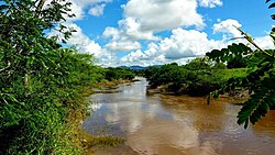
| image_skyline = File:Rio Una em Altinho-PE.jpg |
|||
| image_alt = Una River in Altinho |
|||
| image_caption = [[Una River (Pernambuco)|Una River]] in Altinho |
|||
| image_flag = File:Bandeira de Altinho, Lei Nº 1.223, de 28 de maio de 2012.png |
| image_flag = File:Bandeira de Altinho, Lei Nº 1.223, de 28 de maio de 2012.png |
||
| flag_alt = Flag of Altinho |
| flag_alt = Flag of Altinho |
||
| image_shield = File:Brasão do município de Altinho, Pernambuco - LEI MUNICIPAL Nº 1.360 de 2019.png |
| image_shield = File:Brasão do município de Altinho, Pernambuco - LEI MUNICIPAL Nº 1.360 de 2019.png |
||
| shield_alt = Coat of arms of Altinho |
| shield_alt = Coat of arms of Altinho |
||
| etymology = In English "High", referring to the high [[plain]] the municipality is located on<ref name="IBGEHistoria2024" /> |
|||
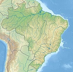
| image_map = File:Brazil Pernambuco Altinho location map.svg |
| image_map = File:Brazil Pernambuco Altinho location map.svg |
||
| map_alt = Location of Altinho in Pernambuco |
| map_alt = Location of Altinho in Pernambuco |
||
| Line 15: | Line 19: | ||
| pushpin_relief = yes |
| pushpin_relief = yes |
||
| coordinates = {{Coord|8|29|24|S|36|03|32|W|region:BR_type:city_source:kolossus-nowiki|display=title,inline}} |
| coordinates = {{Coord|8|29|24|S|36|03|32|W|region:BR_type:city_source:kolossus-nowiki|display=title,inline}} |
||
| subdivision_type = Country |
|||
| subdivision_name = {{flag|Brazil}} |
|||
| subdivision_type1 = [[Regions of Brazil|Region]] |
|||
| subdivision_type2 = [[States of Brazil|State]] |
|||
| subdivision_name1 = [[Northeast Region, Brazil|Northeast]] |
|||
| subdivision_name2 = {{flag|Pernambuco}} |
|||
| established_title = Founded |
|||
| established_date = 11 September 1928<ref name="IBGEHistoria2024">{{cite web |title=História |url=https://cidades.ibge.gov.br/brasil/pe/altinho/historico |website=Instituto Brasileiro de Geografia e Estatística |publisher=Instituto Brasileiro de Geografia e Estatística |access-date=2 September 2024}}</ref> |
|||
| leader_title1 = [[Mayor]] |
|||
| leader_name1 = Orlando José da Silva ([[Brazilian Socialist Party|PSB]]) (2021-2024)<ref name="GloboPrefeito2021">{{cite web |title=Prefeito e vereadores de Altinho tomam posse; veja lista de eleitos |url=https://g1.globo.com/pe/caruaru-regiao/noticia/2021/01/01/prefeito-e-vereadores-de-altinho-tomam-posse-veja-lista-de-eleitos.ghtml |website=globo.com |publisher=globo.com |access-date=2 September 2024}}</ref> |
|||
| leader_title2 = Vice Mayor |
|||
| leader_name2 = José Petrúcio Rodrigues ([[Brazilian Social Democracy Party|PSDB]]) (2021-2024)<ref name="GloboPrefeito2021" /> |
|||
| area_total_km2 = 450.178 |
|||
| elevation_m = 454 |
|||
| population_as_of = 2022 |
|||
| population_total = 20674<ref name="IBGEAltinho2024">{{cite web |title=Altinho |url=https://www.ibge.gov.br/cidades-e-estados/pe/altinho.html |website=Instituto Brasileiro de Geografia e Estatística |publisher=Instituto Brasileiro de Geografia e Estatística |access-date=2 September 2024}}</ref> |
|||
| population_density_km2 = 45.92 |
|||
| population_demonym = ''Altinense'' ([[Brazilian Portuguese]])<ref name="IBGEAltinho2024" /> |
|||
| timezone = [[Brasília Time]] |
|||
| utc_offset = -03:00 |
|||
| postal_code_type = [[Código de Endereçamento Postal|Postal code]] |
|||
| postal_code = 55490-000, 55493-000<ref name="CPAltinho">{{cite web |title=Código Postal Altinho/PE - Brasil |url=https://codigo-postal.org/brasil/pe/altinho/ |website=Código Postal |publisher=Código Postal |access-date=2 September 2024}}</ref> |
|||
| blank_name = [[Human Development Index|HDI]] (2010) |
|||
| blank_info = 0.598 – <span style="color:orange;">medium</span><ref name="IBGEAltinho2024" /> |
|||
| website = [http://altinho.pe.gov.br/ altinho.pe.gov.br] |
|||
}} |
}} |
||
| Line 80: | Line 109: | ||
|- |
|- |
||
|} |
|} |
||
== See also == |
|||
* [[List of municipalities in Pernambuco]] |
|||
==References== |
==References== |
||
Revision as of 16:39, 4 December 2024
Altinho | |
|---|---|
 Una River in Altinho | |
| Etymology: In English "High", referring to the high plain the municipality is located on[1] | |
 Location of Altinho in Pernambuco | |
| Coordinates: 8°29′24″S 36°03′32″W / 8.49000°S 36.05889°W | |
| Country | |
| Region | Northeast |
| State | |
| Founded | 11 September 1928[1] |
| Government | |
| • Mayor | Orlando José da Silva (PSB) (2021-2024)[3] |
| • Vice Mayor | José Petrúcio Rodrigues (PSDB) (2021-2024)[3] |
| Area | |
• Total | 450.178 km2 (173.815 sq mi) |
| Elevation | 454 m (1,490 ft) |
| Population (2022) | |
• Total | 20,674[2] |
| • Density | 45.92/km2 (118.9/sq mi) |
| Demonym | Altinense (Brazilian Portuguese)[2] |
| Time zone | UTC-03:00 (Brasília Time) |
| Postal code | 55490-000, 55493-000[4] |
| HDI (2010) | 0.598 – medium[2] |
| Website | altinho.pe.gov.br |
Altinho is a municipality/city in the state of Pernambuco in Brazil. The population in 2020, according with IBGE was 22,984 inhabitants and the total area is 452.52 km2.[5]
Geography
- State - Pernambuco
- Region - Agreste of Pernambuco
- Boundaries - Caruaru and São Caetano (N); Cupira, Panelas and Ibirajuba (S); Agrestina (E); Cachoeirinha (W).
- Area - 452.52 km2
- Elevation - 454 m
- Hydrography - Una and Ipojuca rivers
- Vegetation - Caatinga hiperxerófila
- Clima - semi arid hot
- Annual average temperature - 23.1 c
- Distance to Recife - 163 km
Economy
The main economic activities in Altinho are related with commerce and agribusiness, especially creations of cattle, sheep, goats, pigs and chickens.
Economic Indicators
| Population [6] | GDP x(1000 R$).[7] | GDP pc (R$) | PE |
|---|---|---|---|
| 22.427 | 63.118 | 2.898 | 0.11% |
Economy by Sector 2006
| Primary sector | Secondary sector | Service sector |
|---|---|---|
| 8.03% | 9.81% | 82.16% |
Health Indicators
| HDI (2000) | Hospitals (2007) | Hospitals beds (2007) | Children's Mortality every 1000 (2005) |
|---|---|---|---|
| 0.590 | 1 | 18 | 18.3 |
See also
References
- ^ a b "História". Instituto Brasileiro de Geografia e Estatística. Instituto Brasileiro de Geografia e Estatística. Retrieved 2 September 2024.
- ^ a b c "Altinho". Instituto Brasileiro de Geografia e Estatística. Instituto Brasileiro de Geografia e Estatística. Retrieved 2 September 2024.
- ^ a b "Prefeito e vereadores de Altinho tomam posse; veja lista de eleitos". globo.com. globo.com. Retrieved 2 September 2024.
- ^ "Código Postal Altinho/PE - Brasil". Código Postal. Código Postal. Retrieved 2 September 2024.
- ^ IBGE 2020
- ^ IBGE Population 2009 Altinho, page 31
- ^ Altinho 2007 GDP IBGE page 29 Archived 4 March 2016 at the Wayback Machine
- ^ PE State site - City by city profile


