Gunnersbury: Difference between revisions
removed uncited/ opinion |
Headhitter (talk | contribs) m →Development: + "a" |
||
| (35 intermediate revisions by 17 users not shown) | |||
| Line 1: | Line 1: | ||
{{Short description|Area of west London, England}} |
|||
{{Use dmy dates|date=September 2015}} |
{{Use dmy dates|date=September 2015}} |
||
{{Use British English|date=September 2015}} |
{{Use British English|date=September 2015}} |
||
{{infobox UK place |
{{infobox UK place |
||
| country = England |
| country = England |
||
| map_type = Greater London |
| map_type = Greater London |
||
| region = London |
| region = London |
||
| population |
| population = |
||
| official_name = Gunnersbury |
| official_name = Gunnersbury |
||
| static_image = The Gunnersbury and the John Bull, Gunnersbury.jpg |
|||
| ⚫ | |||
| static_image_caption = ''The Gunnersbury'' [[public house]] |
|||
| ⚫ | |||
| ⚫ | |||
| ⚫ | |||
| ⚫ | |||
| ⚫ | |||
| ⚫ | |||
| ⚫ | |||
| ⚫ | |||
| ⚫ | |||
| ⚫ | |||
| ⚫ | |||
| ⚫ | |||
| ⚫ | |||
| ⚫ | |||
| ⚫ | |||
| ⚫ | |||
| ⚫ | |||
| ⚫ | |||
| ⚫ | |||
| ⚫ | |||
| ⚫ | |||
| ⚫ | |||
| ⚫ | |||
}} |
}} |
||
'''Gunnersbury''' is an area of |
'''Gunnersbury''' is an area of [[West London]], England. |
||
==Toponymy== |
==Toponymy== |
||
The name "Gunnersbury" |
The name "Gunnersbury" originally meant "Gunner's (Gunnar's) fort", and is a combination of an old Scandinavian personal name + [[Middle English]] -''bury'', meaning, "fort", or "fortified place" .<ref>english-heritage.org.uk/visit/inspire-me/origins-of-english-place-names/</ref> |
||
==Development== |
==Development== |
||
| Line 30: | Line 33: | ||
Gunnersbury consists mainly of pre-war housing of a variety of types, including flats, terrace, semi detached, and [[detached houses]], some of which are ex-local authority built. |
Gunnersbury consists mainly of pre-war housing of a variety of types, including flats, terrace, semi detached, and [[detached houses]], some of which are ex-local authority built. |
||
The defining symbol of Gunnersbury is the 18-storey high BSI ([[British Standards Institution]]) building on Chiswick High Road. Between 1966 and 1992 the block housed a divisional headquarters of [[IBM]] UK. Below this building [[Gunnersbury station]] serves the [[Richmond, London|Richmond]] branch of the [[District line]] and the [[London Overground]] to [[Stratford railway station|Stratford]]. |
The defining symbol of Gunnersbury is the 18-storey high BSI ([[British Standards Institution]]) building on [[Chiswick High Road]]. Between 1966 and 1992 the block housed a divisional headquarters of [[IBM]] UK. Below this building [[Gunnersbury station]] serves the [[Richmond, London|Richmond]] branch of the [[District line]] and the [[London Overground]]'s [[Mildmay line]] to [[Stratford railway station|Stratford]]. |
||
On the north side of the High Road is The Gunnersbury, formerly the John Bull pub, built in 1853, with a billiards saloon built a little later. It became a music venue, visited by bands including [[The Who]].<ref name="Clegg Pubs">{{cite web |last1=Clegg |first1=Gillian |title=Pubs |url=https://brentfordandchiswicklhs.org.uk/search-discover/chiswick-history-homepage/pubs/ |publisher=Brentford & Chiswick Local History Society |access-date=30 July 2021}}</ref> |
|||
| ⚫ | |||
| ⚫ | In August 1921, [[London General Omnibus Company]] established a bus overhaul facility off Chiswick High Road.<ref>[http://archive.commercialmotor.com/article/1st-september-1925/6/inspecting-general-overhaul-works Inspecting General Overhaul Works] ''[[Commercial Motor]]'' 1 September 1925</ref> It incorporated a Training School with a bus [[ |
||
| ⚫ | In August 1921, [[London General Omnibus Company]] established a bus overhaul facility off Chiswick High Road.<ref>[http://archive.commercialmotor.com/article/1st-september-1925/6/inspecting-general-overhaul-works Inspecting General Overhaul Works] ''[[Commercial Motor]]'' 1 September 1925</ref> It incorporated a Training School with a bus [[skidpad|skidpan]].<ref>[https://www.youtube.com/watch?v=YbLy8KZQwtk Chiswick London Bus Rally 1983] YouTube clip</ref> In 1989, [[London Transport Executive (GLC)|London Transport]] closed the works.<ref>[http://archive.commercialmotor.com/article/20th-july-1989/19/bel-grows-in-london BEL grows in London] ''Commercial Motor'' 20 July 1989</ref><ref>{{cite book |last1=Taylor |first1=James |title=The London Bus|date=2009|publisher=Shire Publications |location=Botley |isbn=978-074780-728-5 |page=26}}</ref> In 2001 the site was redeveloped as the Chiswick Business Park with 12 medium density office buildings.<ref>[http://investhounslow.com/developments/chiswick-business-park/ Chiswick Business Park] Invest Hounslow</ref><ref>[http://chiswickherald.co.uk/route-comes-to-chiswick-business-park-p360-203.htm Route 27 Comes to Chiswick Business Park] ''Chiswick Herald''</ref> It houses companies including [[SBS Broadcasting Group|SBS Broadcasting Networks]], [[CBS News]], [[Technicolor]], [[Discovery Channel Europe]], [[Intelsat]], [[Singapore Airlines]], [[Qantas]], [[Foxtons]], and a [[Virgin Active]] health club. |
||
Immediately to the east is [[Gunnersbury Triangle]] nature reserve. An area of woodland, it supports many species of birds, plants, and animals. It has free admission and its entrance is on the south of Bollo Lane, a few yards from [[Chiswick Park tube station|Chiswick Park Tube Station]]. |
|||
Immediately to the east is [[Gunnersbury Triangle]] nature reserve. An area of woodland, it supports many species of birds, plants, and animals. It has free admission and its entrance is on the south of [[Bollo Lane]], a few yards from [[Chiswick Park tube station]].<ref name=LNR>{{cite web |url=http://www.lnr.naturalengland.org.uk/Special/lnr/lnr_details.asp?C=0&N=gunnersbury&ID=190 |title=Gunnersbury Triangle |series=Local Nature Reserves |publisher=Natural England |date=18 December 2013 |access-date=22 January 2014 |archive-date=2 February 2014 |archive-url=https://web.archive.org/web/20140202134017/http://www.lnr.naturalengland.org.uk/Special/lnr/lnr_details.asp?C=0&N=gunnersbury&ID=190 |url-status=dead }}</ref><ref>{{cite web |url=http://magic.defra.gov.uk/MagicMap.aspx?startTopic=Designations&activelayer=lnrIndex&query=REF_CODE%3D%271008928%27 |title=Map of Gunnersbury Triangle|series=Local Nature Reserves|publisher=Natural England |access-date=18 February 2014}}</ref> |
|||
| ⚫ | |||
Just to the north of Gunnersbury Triangle, [[Chiswick Park Footbridge]] connects Gunnersbury's [[Chiswick Business Park]] with Chiswick Park tube station. It was designed by [[Expedition Engineering]] and Useful Studios.<ref>{{cite web| title=New bridge legs bring Crossrail access nearer for Chiswick Park|url =https://chiswickherald.co.uk/new-bridge-legs-bring-crossrail-access-nearer-for-chiswick-park-p7590-95.htm|date=20 December 2017 |website= The Chiswick Herald |publisher= |access-date=18 March 2019}}</ref><ref>{{cite web| title=Chiswick Park Footbridge|url =https://expedition.uk.com/projects/chiswick-park-footbridge/|date=|website= Expedition|publisher= |access-date=18 March 2019}}</ref> |
|||
| ⚫ | In 1886, Gunnersbury was given its own [[parish church]], dedicated to Saint James. The church stood on Chiswick High Road, near Chiswick Roundabout. The church was decommissioned just over a century later, in 1987, and demolished soon afterwards. The parish was united with that of St Paul's, Brentford.<ref>{{cite web|url=http://www.aim25.ac.uk/cgi-bin/vcdf/detail?coll_id=14990&inst_id=118&nv1=search&nv2=|title=Saint James, Gunnersbury: Chiswick High Road, Hounslow|publisher=aim25.ac.uk|access-date=28 September 2015}}</ref> |
||
| ⚫ | Gunnersbury lends its name to a nearby secondary school, formerly a [[grammar school]], in [[Brentford]]. [[Gunnersbury Catholic School]] is a boys-only [[Catholic]] comprehensive with a co-educational sixth form. It used to be located on Gunnersbury Avenue and it backed on to [[Gunnersbury Park]]. Since 1984, it has been located in The Ride, Brentford. |
||
==Nearest areas== |
|||
* [[Acton, London|Acton]] |
|||
| ⚫ | In 1886, Gunnersbury was given its own [[parish church]], dedicated to Saint James. The church stood on [[Chiswick High Road]], near Chiswick Roundabout. The church was decommissioned just over a century later, in 1987, and demolished soon afterwards. The parish was united with that of St Paul's, Brentford.<ref>{{cite web|url=http://www.aim25.ac.uk/cgi-bin/vcdf/detail?coll_id=14990&inst_id=118&nv1=search&nv2=|title=Saint James, Gunnersbury: Chiswick High Road, Hounslow|publisher=aim25.ac.uk|access-date=28 September 2015}}</ref> |
||
* [[Brentford]] |
|||
| ⚫ | |||
<gallery class=center mode=nolines widths=180px heights=180px> |
|||
* [[Kew]] |
|||
File:Gunnersbury Baptist Church.jpg|Gunnersbury Baptist Church |
|||
* [[Mortlake]] |
|||
| ⚫ | |||
| ⚫ | |||
| ⚫ | |||
| ⚫ | |||
| ⚫ | |||
==Transport== |
==Transport== |
||
===Nearest tube stations=== |
===Nearest tube stations=== |
||
* [[Acton Town tube station]] |
* [[Acton Town tube station]] |
||
* [[Gunnersbury station]] |
* [[Gunnersbury station]] |
||
===Nearest railway station=== |
===Nearest railway station=== |
||
* [[Gunnersbury station]] |
* [[Gunnersbury station]] |
||
* [[South Acton railway station (England)|South Acton railway station]] |
* [[South Acton railway station (England)|South Acton railway station]] |
||
==Gallery== |
|||
<gallery> |
|||
| ⚫ | |||
| ⚫ | |||
File:Gunnersbury, Gunnersbury, W4 (4802189047).jpg|''The Gunnersbury'' pub |
|||
| ⚫ | |||
| ⚫ | |||
==References== |
==References== |
||
{{ |
{{reflist|30em}} |
||
==External links== |
==External links== |
||
{{commons category-inline}} |
{{commons category-inline}} |
||
{{Geographic Location |title = '''Adjoining districts''' |Centre = Gunnersbury |
|||
|West = [[Ealing]] |North = [[Acton, London|Acton]] |Southwest = [[Brentford]] |East = [[Chiswick]] |South = [[Kew, London|Kew]]}} |
|||
| ⚫ | |||
{{LB Hounslow}} |
{{LB Hounslow}} |
||
{{Areas of London}} |
{{Areas of London}} |
||
Latest revision as of 23:50, 6 December 2024
| Gunnersbury | |
|---|---|
 The Gunnersbury public house | |
Location within Greater London | |
| OS grid reference | TQ195785 |
| London borough | |
| Ceremonial county | Greater London |
| Region | |
| Country | England |
| Sovereign state | United Kingdom |
| Post town | LONDON |
| Postcode district | W3, W4, W5 |
| Post town | BRENTFORD |
| Postcode district | TW8 |
| Dialling code | 020 |
| Police | Metropolitan |
| Fire | London |
| Ambulance | London |
| UK Parliament | |
| London Assembly | |
Gunnersbury is an area of West London, England.
Toponymy
[edit]The name "Gunnersbury" originally meant "Gunner's (Gunnar's) fort", and is a combination of an old Scandinavian personal name + Middle English -bury, meaning, "fort", or "fortified place" .[1]
Development
[edit]Gunnersbury consists mainly of pre-war housing of a variety of types, including flats, terrace, semi detached, and detached houses, some of which are ex-local authority built.
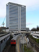
The defining symbol of Gunnersbury is the 18-storey high BSI (British Standards Institution) building on Chiswick High Road. Between 1966 and 1992 the block housed a divisional headquarters of IBM UK. Below this building Gunnersbury station serves the Richmond branch of the District line and the London Overground's Mildmay line to Stratford.
On the north side of the High Road is The Gunnersbury, formerly the John Bull pub, built in 1853, with a billiards saloon built a little later. It became a music venue, visited by bands including The Who.[2]
In August 1921, London General Omnibus Company established a bus overhaul facility off Chiswick High Road.[3] It incorporated a Training School with a bus skidpan.[4] In 1989, London Transport closed the works.[5][6] In 2001 the site was redeveloped as the Chiswick Business Park with 12 medium density office buildings.[7][8] It houses companies including SBS Broadcasting Networks, CBS News, Technicolor, Discovery Channel Europe, Intelsat, Singapore Airlines, Qantas, Foxtons, and a Virgin Active health club.
Immediately to the east is Gunnersbury Triangle nature reserve. An area of woodland, it supports many species of birds, plants, and animals. It has free admission and its entrance is on the south of Bollo Lane, a few yards from Chiswick Park tube station.[9][10]
Just to the north of Gunnersbury Triangle, Chiswick Park Footbridge connects Gunnersbury's Chiswick Business Park with Chiswick Park tube station. It was designed by Expedition Engineering and Useful Studios.[11][12]
Gunnersbury lends its name to a nearby secondary school, formerly a grammar school, in Brentford. Gunnersbury Catholic School is a boys-only Catholic comprehensive with a co-educational sixth form. It used to be located on Gunnersbury Avenue and it backed on to Gunnersbury Park. Since 1984, it has been located in The Ride, Brentford.
In 1886, Gunnersbury was given its own parish church, dedicated to Saint James. The church stood on Chiswick High Road, near Chiswick Roundabout. The church was decommissioned just over a century later, in 1987, and demolished soon afterwards. The parish was united with that of St Paul's, Brentford.[13]
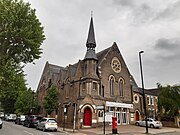
-
Gunnersbury Baptist Church
-
BSI building over Gunnersbury station
-
18th-century mock temple in Gunnersbury Park
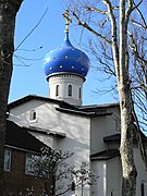
-
Russian Orthodox Church Abroad, Harvard Road
Transport
[edit]Nearest tube stations
[edit]Nearest railway station
[edit]References
[edit]- ^ english-heritage.org.uk/visit/inspire-me/origins-of-english-place-names/
- ^ Clegg, Gillian. "Pubs". Brentford & Chiswick Local History Society. Retrieved 30 July 2021.
- ^ Inspecting General Overhaul Works Commercial Motor 1 September 1925
- ^ Chiswick London Bus Rally 1983 YouTube clip
- ^ BEL grows in London Commercial Motor 20 July 1989
- ^ Taylor, James (2009). The London Bus. Botley: Shire Publications. p. 26. ISBN 978-074780-728-5.
- ^ Chiswick Business Park Invest Hounslow
- ^ Route 27 Comes to Chiswick Business Park Chiswick Herald
- ^ "Gunnersbury Triangle". Local Nature Reserves. Natural England. 18 December 2013. Archived from the original on 2 February 2014. Retrieved 22 January 2014.
- ^ "Map of Gunnersbury Triangle". Local Nature Reserves. Natural England. Retrieved 18 February 2014.
- ^ "New bridge legs bring Crossrail access nearer for Chiswick Park". The Chiswick Herald. 20 December 2017. Retrieved 18 March 2019.
- ^ "Chiswick Park Footbridge". Expedition. Retrieved 18 March 2019.
- ^ "Saint James, Gunnersbury: Chiswick High Road, Hounslow". aim25.ac.uk. Retrieved 28 September 2015.
External links
[edit]![]() Media related to Gunnersbury at Wikimedia Commons
Media related to Gunnersbury at Wikimedia Commons


