Freinberg: Difference between revisions
Appearance
Content deleted Content added
mNo edit summary |
No edit summary |
||
| Line 2: | Line 2: | ||
| name = Freinberg |
| name = Freinberg |
||
| native_name = |
| native_name = |
||
| settlement_type = |
| settlement_type = [[Municipality (Austria)|Municipality]] |
||
<!-- Images --> |
<!-- Images --> |
||
| image_skyline = Ortsansicht Freinberg.jpg |
| image_skyline = Ortsansicht Freinberg.jpg |
||
Latest revision as of 20:46, 9 December 2024
Freinberg | |
|---|---|
 Freinberg | |
 Location within Schärding district | |
| Coordinates: 48°34′00″N 13°31′00″E / 48.56667°N 13.51667°E | |
| Country | Austria |
| State | Upper Austria |
| District | Schärding |
| Government | |
| • Mayor | Anton Pretzl (ÖVP) |
| Area | |
• Total | 20.16 km2 (7.78 sq mi) |
| Elevation | 455 m (1,493 ft) |
| Population (2018-01-01)[2] | |
• Total | 1,458 |
| • Density | 72/km2 (190/sq mi) |
| Time zone | UTC+1 (CET) |
| • Summer (DST) | UTC+2 (CEST) |
| Postal code | 4785 |
| Area code | 07713 |
| Vehicle registration | SD |
| Website | www.freinberg.at |
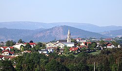
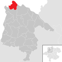
Freinberg is a municipality in the district of Schärding in Upper Austria, Austria. The municipality has an area of 20 square kilometers and population of 1494 (on 31 December 2005).
See also
[edit]References
[edit]- ^ "Dauersiedlungsraum der Gemeinden Politischen Bezirke und Bundesländer - Gebietsstand 1.1.2018". Statistics Austria. Retrieved 10 March 2019.
- ^ "Einwohnerzahl 1.1.2018 nach Gemeinden mit Status, Gebietsstand 1.1.2018". Statistics Austria. Retrieved 9 March 2019.


