Freinberg: Difference between revisions
Appearance
Content deleted Content added
m robot Adding: vi:Freinberg |
No edit summary |
||
| (23 intermediate revisions by 20 users not shown) | |||
| Line 1: | Line 1: | ||
{{Infobox |
{{Infobox settlement |
||
| |
| name = Freinberg |
||
| |
| native_name = |
||
| settlement_type = [[Municipality (Austria)|Municipality]] |
|||
| ⚫ | |||
<!-- Images --> |
|||
|lat_deg = 48 | lat_min = 34 | lat_sec = 00 |
|||
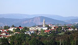
| image_skyline = Ortsansicht Freinberg.jpg |
|||
|lon_deg = 13 | lon_min = 31 | lon_sec = 00 |
|||
| image_caption = Freinberg |
|||
|Bundesland = Oberösterreich |
|||
| ⚫ | |||
| ⚫ | |||
| shield_size = 80x110px |
|||
|Lageplan = Freinberg im Bezirk SD.png |
|||
| |
| shield_link = |
||
<!-- Maps --> |
|||
| |
| pushpin_map = Austria |
||
| pushpin_mapsize = 270 |
|||
| ⚫ | |||
| pushpin_map_caption = Location within Austria |
|||
| ⚫ | |||
| |
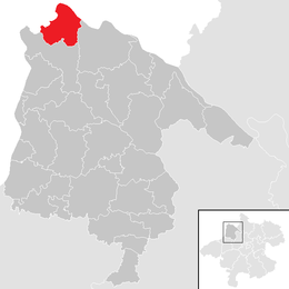
| image_map = Freinberg im Bezirk SD.png |
||
| |
| mapsize = 260x260px |
||
| ⚫ | |||
|Gemeindekennzahl = 41410 |
|||
| |
| map_caption = Location within Schärding district |
||
<!-- Location --> |
|||
|Straße = Haibach 80 |
|||
| coordinates = {{coord|48|34|00|N|13|31|00|E|display=inline,title}} |
|||
| ⚫ | |||
| subdivision_type = Country |
|||
| ⚫ | |||
| subdivision_name = [[Austria]] |
|||
|Partei = ÖVP |
|||
| subdivision_type1 = [[States of Austria|State]] |
|||
|Gemeinderatanzahl = 19 |
|||
| subdivision_name1 = [[Upper Austria]] |
|||
|Gemeinderat = 10 [[ÖVP]], 7 [[SPÖ]], 2 [[FPÖ]] |
|||
| subdivision_type2 = [[District (Austria)|District]] |
|||
|Wahljahr = 2003 |
|||
| subdivision_name2 = [[Schärding District|Schärding]] |
|||
|Bild1 = Pfarrkirche Freinberg.JPG |
|||
| parts_type = |
|||
|Bildbeschreibung1 = Die Pfarrkirche von Freinberg |
|||
| parts_style = para |
|||
| ⚫ | |||
<!-- Leaders --> |
|||
| leader_title = [[Burgomaster|Mayor]] |
|||
| ⚫ | |||
| leader_party = {{Polparty|Austria| ÖVP }} |
|||
| leader_title1 = |
|||
| leader_name1 = |
|||
<!-- Statistics --> |
|||
| area_footnotes = {{Austria population Wikidata|area_footnotes}} |
|||
| area_total_km2 = {{Austria population Wikidata|area_total_km2}} |
|||
| area_metro_km2 = |
|||
| elevation_m = 455 |
|||
| elevation_max_m = |
|||
| elevation_min_m = |
|||
| population_as_of = {{Austria population Wikidata|population_as_of}} |
|||
| population_footnotes = {{Austria population Wikidata|population_footnotes}} |
|||
| population_total = {{Austria population Wikidata|population_total}} |
|||
| population_urban = |
|||
| population_metro = |
|||
| population_note = |
|||
| population_density_km2 = auto |
|||
| established_title = |
|||
| established_date = |
|||
| timezone = [[Central European Time|CET]] |
|||
| timezone_DST = [[Central European Summer Time|CEST]] |
|||
| utc_offset = +1 |
|||
| utc_offset_DST = +2 |
|||
| registration_plate = [[Vehicle registration plates of Austria|SD]] |
|||
| postal_code_type = [[List of postal codes in Austria|Postal code]] |
|||
| ⚫ | |||
| area_code_type = [[Telephone numbers in Austria|Area code]] |
|||
| area_code = 07713 |
|||
| ⚫ | |||
| footnotes = |
|||
}} |
}} |
||
'''Freinberg''' is a municipality in the district of [[Schärding (district)|Schärding]] in [[Upper Austria]], [[Austria]]. |
'''Freinberg''' is a municipality in the district of [[Schärding (district)|Schärding]] in [[Upper Austria]], [[Austria]]. |
||
The municipality has an area of 20 square kilometers and population of 1494 (on 31 December 2005). |
The municipality has an area of 20 square kilometers and population of 1494 (on 31 December 2005). |
||
== See also == |
|||
| ⚫ | |||
==References== |
|||
{{reflist}} |
|||
{{Cities and towns in Schärding (district)}} |
{{Cities and towns in Schärding (district)}} |
||
| ⚫ | |||
{{coord|48.567|N|13.517|E|display=title|source:dewiki}} |
|||
{{authority control}} |
|||
| ⚫ | |||
| ⚫ | |||
| ⚫ | |||
[[ |
[[Category:Sauwald]] |
||
[[nl:Freinberg]] |
|||
[[pt:Freinberg]] |
|||
| ⚫ | |||
[[ru:Фрайнберг]] |
|||
[[sk:Freinberg]] |
|||
[[vi:Freinberg]] |
|||
[[vo:Freinberg]] |
|||
Latest revision as of 20:46, 9 December 2024
Freinberg | |
|---|---|
 Freinberg | |
 Location within Schärding district | |
| Coordinates: 48°34′00″N 13°31′00″E / 48.56667°N 13.51667°E | |
| Country | Austria |
| State | Upper Austria |
| District | Schärding |
| Government | |
| • Mayor | Anton Pretzl (ÖVP) |
| Area | |
• Total | 20.16 km2 (7.78 sq mi) |
| Elevation | 455 m (1,493 ft) |
| Population (2018-01-01)[2] | |
• Total | 1,458 |
| • Density | 72/km2 (190/sq mi) |
| Time zone | UTC+1 (CET) |
| • Summer (DST) | UTC+2 (CEST) |
| Postal code | 4785 |
| Area code | 07713 |
| Vehicle registration | SD |
| Website | www.freinberg.at |
Freinberg is a municipality in the district of Schärding in Upper Austria, Austria. The municipality has an area of 20 square kilometers and population of 1494 (on 31 December 2005).
See also
[edit]References
[edit]- ^ "Dauersiedlungsraum der Gemeinden Politischen Bezirke und Bundesländer - Gebietsstand 1.1.2018". Statistics Austria. Retrieved 10 March 2019.
- ^ "Einwohnerzahl 1.1.2018 nach Gemeinden mit Status, Gebietsstand 1.1.2018". Statistics Austria. Retrieved 9 March 2019.


