Noordwolde, Friesland: Difference between revisions
BigBullfrog (talk | contribs) IPA |
|||
| (7 intermediate revisions by 5 users not shown) | |||
| Line 1: | Line 1: | ||
{{distinguish|Noordwolde, Groningen}} |
{{distinguish|Noordwolde, Groningen}} |
||
{{Expand West Frisian|topic=geo|date=December 2008|Noardwâlde (Weststellingwerf)}} |
|||
{{Infobox settlement |
{{Infobox settlement |
||
| name = Noordwolde |
| name = Noordwolde |
||
| native_name = |
| native_name = |
||
| native_name_lang = <!-- ISO 639-2 code e.g. "fr" for French. If more than one, use {{lang}} instead --> |
| native_name_lang = <!-- ISO 639-2 code e.g. "fr" for French. If more than one, use {{lang}} instead --> |
||
| settlement_type = Village |
| settlement_type = Village |
||
| Line 21: | Line 20: | ||
| map_alt = |
| map_alt = |
||
| map_caption = Location in Weststellingwerf municipality |
| map_caption = Location in Weststellingwerf municipality |
||
| pushpin_map = Netherlands<!-- the name of a location map as per http://en.wikipedia.org/wiki/Template:Location_map --> |
| pushpin_map = Netherlands Friesland#Netherlands<!-- the name of a location map as per http://en.wikipedia.org/wiki/Template:Location_map --> |
||
| pushpin_label_position = |
| pushpin_label_position = left |
||
| pushpin_mapsize = 250 |
| pushpin_mapsize = 250 |
||
| pushpin_map_caption = Location in the Netherlands |
| pushpin_map_caption = Location in the Netherlands |
||
| Line 48: | Line 47: | ||
<!-- ALL fields with measurements have automatic unit conversion --> |
<!-- ALL fields with measurements have automatic unit conversion --> |
||
<!-- for references: use <ref> tags --> |
<!-- for references: use <ref> tags --> |
||
| area_footnotes = |
| area_footnotes = <ref name="stat"/> |
||
| ⚫ | |||
| area_urban_footnotes = <!-- <ref> </ref> --> |
|||
| elevation_footnotes = <ref name="AHN">{{cite web |url = http://www.ahn.nl/postcodetool |title = Postcodetool for 8391AA |language = nl |work = Actueel Hoogtebestand Nederland |publisher = Het Waterschapshuis |access-date = 2 April 2022 }}</ref> |
|||
| area_rural_footnotes = <!-- <ref> </ref> --> |
|||
| ⚫ | |||
| area_metro_footnotes = <!-- <ref> </ref> --> |
|||
| |
| population_as_of = 2021 |
||
| population_footnotes = <ref name="stat">{{cite web |url=https://www.cbs.nl/-/media/_excel/2021/48/kwb-2021.xls |title=Kerncijfers wijken en buurten 2021 |website=Central Bureau of Statistics |access-date=2 April 2022}}</ref> |
|||
| ⚫ | |||
| |
| population_total = 3,645 |
||
| area_rank = |
|||
| area_blank1_title = |
|||
| area_blank2_title = |
|||
<!-- square kilometers --> |
|||
| ⚫ | |||
| area_land_km2 = |
|||
| ⚫ | |||
| area_urban_km2 = |
|||
| area_rural_km2 = |
|||
| area_metro_km2 = |
|||
| area_blank1_km2 = |
|||
| area_blank2_km2 = |
|||
<!-- hectares --> |
|||
| area_total_ha = |
|||
| area_land_ha = |
|||
| area_water_ha = |
|||
| area_urban_ha = |
|||
| area_rural_ha = |
|||
| area_metro_ha = |
|||
| area_blank1_ha = |
|||
| area_blank2_ha = |
|||
| length_km = |
|||
| width_km = |
|||
| dimensions_footnotes = |
|||
| elevation_footnotes = |
|||
| ⚫ | |||
| population_as_of = January 2017 |
|||
| population_footnotes = |
|||
| population_total = 3596 |
|||
| population_density_km2 = auto |
| population_density_km2 = auto |
||
| population_note = |
| population_note = |
||
| population_demonym = |
| population_demonym = |
||
| timezone1 = |
| timezone1 = |
||
| utc_offset1 = |
| utc_offset1 = |
||
| timezone1_DST = |
| timezone1_DST = |
||
| utc_offset1_DST = |
| utc_offset1_DST = |
||
| timezone = [[Central European Time|CET]] |
|||
| ⚫ | |||
| timezone_DST = [[Central European Summer Time|CEST]] |
|||
| ⚫ | |||
| postal_code_type = [[List of postal codes in the Netherlands|Postal code]] |
| postal_code_type = [[List of postal codes in the Netherlands|Postal code]] |
||
| postal_code = 8391 |
| postal_code = 8391<ref name="stat"/> |
||
| area_code_type = [[Telephone numbers in the Netherlands|Dialing code]] |
| area_code_type = [[Telephone numbers in the Netherlands|Dialing code]] |
||
| area_code = 0561 |
| area_code = 0561 |
||
| iso_code = |
| iso_code = |
||
| website = [http://www.noordwolde.me/ Website about Noordwolde] |
|||
| footnotes = |
| footnotes = |
||
}} |
}} |
||
'''Noordwolde''' ({{ |
'''Noordwolde''' ({{IPA|nl|ˈnoːrtˌʋɔldə}}; {{langx|fy|Noardwâlde}}) is a village in [[Weststellingwerf]] in the province of [[Friesland]], the [[Netherlands]]. It had a population of around 3,600 as of 2017.<ref>[https://www.weststellingwerf.nl/ontdek-weststellingwerf/kerngegevens-gemeente-weststellingwerf_41292/ Villages] - Weststellingwerf municipality {{in lang|nl}}</ref> {{ill|Noordwolde-Zuid|nl}}, the settlement to the south of Noordwolde is considered a separate village.<ref name="plaats"/> |
||
There is a restored [[windmill]] in the village, [[Windlust, Noordwolde|''Windlust'']]. |
There is a restored [[windmill]] in the village, [[Windlust, Noordwolde|''Windlust'']]. |
||
The National Museum of Weaving is located in the village. |
The National Museum of Weaving is located in the village. There is a natural lake, the Spokedam, which is partly surrounded by a beach, on the outskirts of Noordwolde. There are several camp sites near the lake such as "Hanestede" and the bungalow park "The Bosmeer". |
||
There is a natural lake, the Spokedam, which is partly surrounded by a beach, on the outskirts of Noordwolde. There are several camp sites near the lake such as "Hanestede" and the bungalow park "The Bosmeer". |
|||
There is a swimming pool beside the Spokedam. There are two supermarkets and several other shops and restaurants in the village and |
There is a swimming pool beside the Spokedam. There are two supermarkets and several other shops and restaurants in the village, and the largest model train shop (G-scale) in Europe is in Noordwolde. |
||
the largest model train shop (G-scale) in Europe is in Noordwolde. |
|||
== History == |
|||
The village was first mentioned in 1408 as Noortwolde, and means "northern woods".<ref>{{cite web|url=https://etymologiebank.nl/trefwoord/noordwolde |title=Noordwolde - (geografische naam) |website=Etymologiebank |access-date=2 April 2022 |language=nl}}</ref> Noordwolde is a [[peat]] excavation village which developed at the intersection of the Hoofdstraat with the Kolonievaart. Up to the 19th century, it was the capital of the ''[[grietenij]]'' (predecessor of the municipality) [[Weststellingwerf]].<ref name="monument">{{cite web|url=https://www.dbnl.org/tekst/sten009monu06_01/sten009monu06_01_0124.php |title=Noordwolde |author=Ronald Stenvert & Sabine Broekhoven |year=2000 |publisher=Waanders |location=Zwolle |isbn=90 400 9476 4 |language=nl |access-date=2 April 2022}}</ref> |
|||
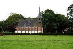
The Dutch Reformed church was built between 1639 and 1640 as a replacement of its medieval predecessor. The church was enlarged in 1853.<ref name="monument"/> |
|||
Noordwolde was home to 1,792 people in 1840.<ref name="plaats">{{cite web|url=https://www.plaatsengids.nl/noordwolde-frysl%C3%A2n |title=Noordwolde (Fryslan) |website=Plaatsengids |access-date=2 April 2022|language=nl}}</ref> In the mid-19th century, Noordwolde became a centre for weaving, basket making and chair production.<ref name="monument"/> In 1912,<ref name="plaats"/> a [[weaving]] school was founded in Noordwolde. The building nowadays houses a museum dedicated to weaving.<ref name="monument"/> |
|||
==Notable people== |
|||
* [[Johan Eilerts de Haan]] (1865–1910), Dutch explorer<ref>{{cite web|url=https://suriname.nu/surinamezoeken/knowledge-base/johan-eilerts-de-haan/ |title=Johan Eilerts de Haan|website=Suriname.nu |access-date=2 April 2022 |language=nl}}</ref> |
|||
==Gallery== |
|||
<gallery> |
|||
File:Hoofdstraat Oost 34 Noordwolde.jpg|Weaving museum |
|||
File:Voormalig tramstation NTM - panoramio.jpg|Former tram station used by the fire department |
|||
File:Hier info in Noordwolde.JPG|Tourist information |
|||
File:Spokeplas Noordwolde 2008.jpg|Spokeplas near Noordwolde |
|||
</gallery> |
|||
==References== |
==References== |
||
| Line 114: | Line 104: | ||
* [http://www.blikopweststellingwerf.nl/ Noordwolde en de gemeente Weststellingwerf, plaatselijk nieuws] |
* [http://www.blikopweststellingwerf.nl/ Noordwolde en de gemeente Weststellingwerf, plaatselijk nieuws] |
||
{{Dutch municipality Weststellingwerf}} |
|||
{{Authority control}} |
|||
[[Category:Geography of Weststellingwerf]] |
|||
[[Category:Populated places in Friesland]] |
[[Category:Populated places in Friesland]] |
||
{{Friesland-geo-stub}} |
|||
Latest revision as of 14:21, 11 December 2024
Noordwolde | |
|---|---|
Village | |
 Noordwolde Church | |
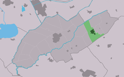
 Location in Weststellingwerf municipality | |
| Coordinates: 52°53′29″N 6°8′32″E / 52.89139°N 6.14222°E | |
| Country | |
| Province | |
| Municipality | |
| Area | |
• Total | 12.42 km2 (4.80 sq mi) |
| Elevation | 2.4 m (7.9 ft) |
| Population (2021)[1] | |
• Total | 3,645 |
| • Density | 290/km2 (760/sq mi) |
| Postal code | 8391[1] |
| Dialing code | 0561 |
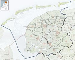
Noordwolde (Dutch pronunciation: [ˈnoːrtˌʋɔldə]; West Frisian: Noardwâlde) is a village in Weststellingwerf in the province of Friesland, the Netherlands. It had a population of around 3,600 as of 2017.[3] Noordwolde-Zuid, the settlement to the south of Noordwolde is considered a separate village.[4]
There is a restored windmill in the village, Windlust. The National Museum of Weaving is located in the village. There is a natural lake, the Spokedam, which is partly surrounded by a beach, on the outskirts of Noordwolde. There are several camp sites near the lake such as "Hanestede" and the bungalow park "The Bosmeer".
There is a swimming pool beside the Spokedam. There are two supermarkets and several other shops and restaurants in the village, and the largest model train shop (G-scale) in Europe is in Noordwolde.
History
[edit]The village was first mentioned in 1408 as Noortwolde, and means "northern woods".[5] Noordwolde is a peat excavation village which developed at the intersection of the Hoofdstraat with the Kolonievaart. Up to the 19th century, it was the capital of the grietenij (predecessor of the municipality) Weststellingwerf.[6]
The Dutch Reformed church was built between 1639 and 1640 as a replacement of its medieval predecessor. The church was enlarged in 1853.[6]
Noordwolde was home to 1,792 people in 1840.[4] In the mid-19th century, Noordwolde became a centre for weaving, basket making and chair production.[6] In 1912,[4] a weaving school was founded in Noordwolde. The building nowadays houses a museum dedicated to weaving.[6]
Notable people
[edit]- Johan Eilerts de Haan (1865–1910), Dutch explorer[7]
Gallery
[edit]-
Weaving museum
-
Former tram station used by the fire department
-
Tourist information
-
Spokeplas near Noordwolde
References
[edit]- ^ a b c "Kerncijfers wijken en buurten 2021". Central Bureau of Statistics. Retrieved 2 April 2022.
- ^ "Postcodetool for 8391AA". Actueel Hoogtebestand Nederland (in Dutch). Het Waterschapshuis. Retrieved 2 April 2022.
- ^ Villages - Weststellingwerf municipality (in Dutch)
- ^ a b c "Noordwolde (Fryslan)". Plaatsengids (in Dutch). Retrieved 2 April 2022.
- ^ "Noordwolde - (geografische naam)". Etymologiebank (in Dutch). Retrieved 2 April 2022.
- ^ a b c d Ronald Stenvert & Sabine Broekhoven (2000). "Noordwolde" (in Dutch). Zwolle: Waanders. ISBN 90 400 9476 4. Retrieved 2 April 2022.
- ^ "Johan Eilerts de Haan". Suriname.nu (in Dutch). Retrieved 2 April 2022.
External links
[edit]![]() Media related to Noordwolde, Friesland at Wikimedia Commons
Media related to Noordwolde, Friesland at Wikimedia Commons


