Tuco (mountain): Difference between revisions
Volcanoguy (talk | contribs) removed Category:Mountains of Peru using HotCat |
|||
| (46 intermediate revisions by 21 users not shown) | |||
| Line 1: | Line 1: | ||
{{short description|Mountain in Peru}} |
|||
{{About||the Zimbabwean musician|Oliver "Tuku" Mtukudzi{{!}}Oliver "Tuku" Mtukudzi}} |
|||
{{Infobox mountain |
{{Infobox mountain |
||
| name = |
| name = Tuco |
||
| ⚫ | |||
| photo = Nevado Tuco.jpg |
| photo = Nevado Tuco.jpg |
||
| |
| photo_caption = Tuco |
||
| |
| map = Peru |
||
| |
| map_caption = Peru |
||
| |
| location = [[Peru]], [[Ancash Region]] |
||
| ⚫ | |||
| coordinates = {{coord|9|55|27|S|77|11|57|W|type:mountain_region:PE_scale:100000|format=dms|display=inline,title}} |
|||
| elevation_m = 5479 |
| elevation_m = 5479 |
||
| ⚫ | |||
| elevation_ref = <ref name=neate>Taken from Mountaineering in the Andes by Jill Neate Peru RGS-IBG Expedition Advisory Centre, 2nd edition, May 1994</ref> |
| elevation_ref = <ref name=neate>Taken from Mountaineering in the Andes by Jill Neate Peru RGS-IBG Expedition Advisory Centre, 2nd edition, May 1994</ref> |
||
| ⚫ | |||
| prominence_m = |
| prominence_m = |
||
| prominence_ft = |
|||
| prominence_ref = |
| prominence_ref = |
||
| ⚫ | |||
| listing = |
| listing = |
||
| range = [[Cordillera Blanca]] |
| range = [[Cordillera Blanca]] |
||
| |
| range_coordinates = |
||
| location = [[Peru]], [[Ancash Region]] |
|||
| map = Peru |
|||
| map_alt = |
|||
| map_caption = |
|||
| map_relief = |
|||
| map_size = |
|||
| label = |
|||
| ⚫ | |||
| lat_d = 9 |
|||
| lat_m = 55 |
|||
| lat_s = 45 |
|||
| lat_NS = S |
|||
| long_d = 77 |
|||
| long_m = 11 |
|||
| long_s = 50 |
|||
| long_EW = W |
|||
| x = |
|||
| y = |
|||
| region = PE |
|||
| coordinates = |
|||
| coordinates_ref = |
| coordinates_ref = |
||
| grid_ref_UK = |
|||
| grid_ref_Ireland = |
|||
| topo = |
|||
| type = |
|||
| volcanic_arc/belt = |
|||
| age = |
|||
| last_eruption = |
|||
| first_ascent = 1-1963 via N.W. slopes<ref name=neate/> |
| first_ascent = 1-1963 via N.W. slopes<ref name=neate/> |
||
| easiest_route = |
| easiest_route = |
||
| other_name = '''Tuku''', '''Huanaco Punta''' |
|||
| ⚫ | |||
| ⚫ | |||
}} |
}} |
||
'''Tuku''' ([[Quechua language|Quechua]] ''tuku'' [[owl]] |
'''Tuco,'''<ref>John Biggar, The Andes: A Guide for Climbers.2015</ref><ref>{{Cite book|url=http://www.batguano.com/hamlet/peru2005/maps/cbmapb.jpg|title=Carta Turística. Cordilleras Blanca, Negra, Huayhuash y Callejón de Huaylas.|last=Díaz|first=Felipe|year=2008–2009}}</ref><ref name="ReferenceA">escale.minedu.gob.pe - UGEL map of the Bolognesi Province (Ancash Region)</ref> '''Tuku,'''<ref name=neate/> '''Tucu'''<ref name=":0">{{Cite book|title=Alpenvereinskarte 0/3b. Cordillera Blanca Süd (Peru). 1:100 000|publisher=Oesterreichischer Alpenverein|year=2005|isbn=3-937530-05-3}}</ref> (possibly from [[Quechua language|Quechua]] ''tuku'', [[owl]])<ref name="laime">{{Ref Laime}}</ref> or '''Huanaco Punta'''<ref name=":1">{{Cite book|title=Peru 1:100 000, Recuay (20-i)|publisher=IGN (Instituto Geográfico Nacional - Perú)}}</ref> (possibly from Quechua ''wanaku'' [[guanaco]] and Spanish ''punta'' peak, ridge; first, before, in front of)<ref name=laime/><ref>David Weber, A Grammar of Huallaga (Huánuco) Quechua, University of California Press, p. 185</ref><ref>[http://homepage.ntlworld.com/robert_beer/Vocabulario%20comparativo%20Quechua%20ecuator%20Quechua%20ancash%20-%2020%20Oct%2006.PDF homepage.ntlworld.com/robert_beer] Robert Beér, Armando Muyolemaj, Dr. Hernán S. Aguilarpaj, Vocabulario comparativo, quechua ecuatoriano - quechua ancashino - castellano - English, Brighton 2006: Spanish ''Casa'', Kichwa ''Wasi'', Ancash Quechua ''Wayi'', English ''House''</ref> is a mountain in the [[Andes]] in [[South America]]. Its summit is {{convert|5479|m|abbr=on}}) high and it is one of the southernmost peaks in the snow-capped [[Cordillera Blanca]] in northwestern central [[Peru]]. Tuco is located in the [[Ancash Region]], [[Bolognesi Province]], [[Aquia District]] and in the [[Recuay Province]], [[Catac District]].<ref name="ReferenceA"/> It is situated northeast of [[Caullaraju]], between [[Challhua]] in the west and [[Pastoruri Glacier|Pastoruri]] in the east.<ref name=":1" /> |
||
Other neighboring peaks are Juchuraju ({{convert|5392|m|abbr=on}}) and |
Other neighboring peaks are Juchuraju or Condorjitanca ({{convert|5392|m|abbr=on}}) and [[Santón]] ({{convert|5100|m|ft|abbr=on}}).<ref name=":0" /><ref name=":1" /> [[Raju Cutac]] ({{convert|5355|m|ft|abbr=on}}) is the only peak further south in the Cordillera Blanca.<ref name=":0" /><ref name=":1" /> |
||
A stream also named Tuco originates near the mountain and flows out to lakes Aguashcocha and [[Lake Conococha|Conococha]], at the headwaters of [[Santa River]].<ref name=":0" /><ref name=":1" /> |
|||
The glacial lakes on the southern flank of Tuku are the source of the Tuku River, with a length of {{convert|30|km|mi|abbr=on}} the main tributary of the lake [[Quñuqqucha]]. From there the [[Santa River|Santa]] River flows along the Cordillera Blanca into the [[Pacific Ocean]]. |
|||
== Sources == |
== Sources == |
||
{{reflist}} |
{{reflist}} |
||
| ⚫ | |||
==External links== |
|||
| ⚫ | |||
{{Commons category-inline|Nevado de Tuco|Tuku}} |
|||
[[Category:Five-thousanders of the Andes]] |
|||
| ⚫ | |||
| ⚫ | |||
[[Category:Ancash Region]] |
|||
{{ |
{{Ancash-geo-stub}} |
||
Latest revision as of 20:09, 13 December 2024
| Tuco | |
|---|---|
| Tuku, Huanaco Punta | |
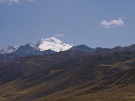
 Tuco | |
| Highest point | |
| Elevation | 5,479 m (17,976 ft)[1] |
| Coordinates | 9°55′27″S 77°11′57″W / 9.92417°S 77.19917°W |
| Geography | |
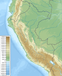
| Location | Peru, Ancash Region |
| Parent range | Cordillera Blanca |
| Climbing | |
| First ascent | 1-1963 via N.W. slopes[1] |
Tuco,[2][3][4] Tuku,[1] Tucu[5] (possibly from Quechua tuku, owl)[6] or Huanaco Punta[7] (possibly from Quechua wanaku guanaco and Spanish punta peak, ridge; first, before, in front of)[6][8][9] is a mountain in the Andes in South America. Its summit is 5,479 m (17,976 ft)) high and it is one of the southernmost peaks in the snow-capped Cordillera Blanca in northwestern central Peru. Tuco is located in the Ancash Region, Bolognesi Province, Aquia District and in the Recuay Province, Catac District.[4] It is situated northeast of Caullaraju, between Challhua in the west and Pastoruri in the east.[7]
Other neighboring peaks are Juchuraju or Condorjitanca (5,392 m (17,690 ft)) and Santón (5,100 m (16,700 ft)).[5][7] Raju Cutac (5,355 m (17,569 ft)) is the only peak further south in the Cordillera Blanca.[5][7]
A stream also named Tuco originates near the mountain and flows out to lakes Aguashcocha and Conococha, at the headwaters of Santa River.[5][7]
Sources
[edit]- ^ a b c Taken from Mountaineering in the Andes by Jill Neate Peru RGS-IBG Expedition Advisory Centre, 2nd edition, May 1994
- ^ John Biggar, The Andes: A Guide for Climbers.2015
- ^ Díaz, Felipe (2008–2009). Carta Turística. Cordilleras Blanca, Negra, Huayhuash y Callejón de Huaylas.
- ^ a b escale.minedu.gob.pe - UGEL map of the Bolognesi Province (Ancash Region)
- ^ a b c d Alpenvereinskarte 0/3b. Cordillera Blanca Süd (Peru). 1:100 000. Oesterreichischer Alpenverein. 2005. ISBN 3-937530-05-3.
- ^ a b Teofilo Laime Ajacopa (2007). Diccionario Bilingüe: Iskay simipi yuyayk’anch: Quechua – Castellano / Castellano – Quechua (PDF). La Paz, Bolivia: futatraw.ourproject.org.
- ^ a b c d e Peru 1:100 000, Recuay (20-i). IGN (Instituto Geográfico Nacional - Perú).
- ^ David Weber, A Grammar of Huallaga (Huánuco) Quechua, University of California Press, p. 185
- ^ homepage.ntlworld.com/robert_beer Robert Beér, Armando Muyolemaj, Dr. Hernán S. Aguilarpaj, Vocabulario comparativo, quechua ecuatoriano - quechua ancashino - castellano - English, Brighton 2006: Spanish Casa, Kichwa Wasi, Ancash Quechua Wayi, English House

