Strzelno, Pomeranian Voivodeship: Difference between revisions
Appearance
Content deleted Content added
m →top: Format administrative division links, remove DEFAULTSORTKEY as per WP:SORTKEY, remove One Source for stubs, minor formatting changes (AWB) |
|||
| (11 intermediate revisions by 11 users not shown) | |||
| Line 1: | Line 1: | ||
{{ |
{{other places|Strzelno}} |
||
{{Infobox |
{{Infobox settlement |
||
| name = Strzelno |
| name = Strzelno |
||
| settlement_type = Village |
| settlement_type = Village |
||
| total_type = |
| total_type = |
||
| image_skyline = |
| image_skyline = Strzelno - Church 01.jpg |
||
| image_caption = |
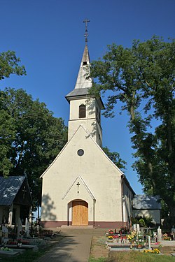
| image_caption = Saint Mary Magdalene church in Strzelno |
||
| image_flag = |
| image_flag = |
||
| image_shield = |
| image_shield = |
||
| image_map = |
| image_map = |
||
| subdivision_type = [[ |
| subdivision_type = [[List of sovereign states|Country]] |
||
| subdivision_name = {{ |
| subdivision_name = {{POL}} |
||
| subdivision_type1 = [[Voivodeships of Poland|Voivodeship]] |
| subdivision_type1 = [[Voivodeships of Poland|Voivodeship]] |
||
| subdivision_name1 = [[Pomeranian Voivodeship|Pomeranian]] |
| subdivision_name1 = [[Pomeranian Voivodeship|Pomeranian]] |
||
| Line 16: | Line 16: | ||
| subdivision_name2 = [[Puck County|Puck]] |
| subdivision_name2 = [[Puck County|Puck]] |
||
| subdivision_type3 = [[Gmina]] |
| subdivision_type3 = [[Gmina]] |
||
| subdivision_name3 = [[Gmina Puck]] |
| subdivision_name3 = [[Gmina Puck|Puck]] |
||
| ⚫ | |||
| latd = 54 |
|||
| latm = 47 |
|||
| lats = 7 |
|||
| latNS = N |
|||
| longd = 18 |
|||
| longm = 19 |
|||
| longs = 29 |
|||
| longEW = E |
|||
| pushpin_map = Poland |
| pushpin_map = Poland |
||
| pushpin_label_position = right |
| pushpin_label_position = right |
||
| timezone = [[Central European Time|CET]] |
|||
| ⚫ | |||
| utc_offset = +1 |
|||
| timezone_DST = [[Central European Summer Time|CEST]] |
|||
| utc_offset_DST = +2 |
|||
| registration_plate = GPU |
|||
| ⚫ | |||
| population_total = 1063 |
| population_total = 1063 |
||
| website = }} |
| website = |
||
}} |
|||
'''Strzelno''' {{IPAc-pl|'|s|t|sz|e|l|n|o}} is a [[village]] in the administrative district of [[Gmina Puck]], within [[Puck County]], [[Pomeranian Voivodeship]], in northern Poland.<ref name="TERYT">{{cite web |url=http://www.stat.gov.pl/broker/access/prefile/listPreFiles.jspa |title=Central Statistical Office (GUS) - TERYT (National Register of Territorial Land Apportionment Journal) |date=2008-06-01 |language=Polish}}</ref> It lies approximately {{convert|11|km|mi|0}} north-west of [[Puck, Poland|Puck]] and {{convert|51|km|mi|0|abbr=on}} north-west of the regional capital [[Gdańsk]]. |
'''Strzelno''' {{IPAc-pl|'|s|t|sz|e|l|n|o}} is a [[village]] in the administrative district of [[Gmina Puck]], within [[Puck County]], [[Pomeranian Voivodeship]], in northern Poland.<ref name="TERYT">{{cite web |url=http://www.stat.gov.pl/broker/access/prefile/listPreFiles.jspa |title=Central Statistical Office (GUS) - TERYT (National Register of Territorial Land Apportionment Journal) |date=2008-06-01 |language=Polish}}</ref> It lies approximately {{convert|11|km|mi|0}} north-west of [[Puck, Poland|Puck]] and {{convert|51|km|mi|0|abbr=on}} north-west of the regional capital [[Gdańsk]]. It is located within the ethnocultural region of [[Kashubia]] in the historic region of [[Pomerania]]. |
||
Strzelno was a royal village of the [[Crown of the Kingdom of Poland|Polish Crown]], administratively located in the Puck County in the [[Pomeranian Voivodeship (1466–1772)|Pomeranian Voivodeship]].<ref>{{cite book|last1=Biskup|first1=Marian|last2=Tomczak|first2=Andrzej|year=1955|title=Mapy województwa pomorskiego w drugiej połowie XVI w.|language=Polish|location=Toruń|page=101}}</ref> |
|||
For details of the history of the region, see ''[[History of Pomerania]]''. |
|||
The village has a population of 1,063. |
|||
==References== |
==References== |
||
{{ |
{{Reflist}} |
||
<br> |
|||
{{Gmina Puck}} |
{{Gmina Puck}} |
||
{{Authority control}} |
|||
| ⚫ | |||
[[Category:Villages in Puck County |
[[Category:Villages in Puck County]] |
||
| ⚫ | |||
[[pl:Strzelno (województwo pomorskie)]] |
|||
| ⚫ | |||
Latest revision as of 02:40, 15 December 2024
Strzelno | |
|---|---|
Village | |
 Saint Mary Magdalene church in Strzelno | |
| Coordinates: 54°47′7″N 18°19′29″E / 54.78528°N 18.32472°E | |
| Country | |
| Voivodeship | Pomeranian |
| County | Puck |
| Gmina | Puck |
| Population | 1,063 |
| Time zone | UTC+1 (CET) |
| • Summer (DST) | UTC+2 (CEST) |
| Vehicle registration | GPU |
Strzelno [ˈstʂɛlnɔ] is a village in the administrative district of Gmina Puck, within Puck County, Pomeranian Voivodeship, in northern Poland.[1] It lies approximately 11 kilometres (7 mi) north-west of Puck and 51 km (32 mi) north-west of the regional capital Gdańsk. It is located within the ethnocultural region of Kashubia in the historic region of Pomerania.
Strzelno was a royal village of the Polish Crown, administratively located in the Puck County in the Pomeranian Voivodeship.[2]
References
[edit]- ^ "Central Statistical Office (GUS) - TERYT (National Register of Territorial Land Apportionment Journal)" (in Polish). 2008-06-01.
- ^ Biskup, Marian; Tomczak, Andrzej (1955). Mapy województwa pomorskiego w drugiej połowie XVI w. (in Polish). Toruń. p. 101.
{{cite book}}: CS1 maint: location missing publisher (link)


