Olevsk: Difference between revisions
BrandonXLF (talk | contribs) Float left |
Added audio file |
||
| (6 intermediate revisions by 5 users not shown) | |||
| Line 1: | Line 1: | ||
{{short description|City in Zhytomyr Oblast, Ukraine}} |
{{short description|City in Zhytomyr Oblast, Ukraine}} |
||
{{Infobox settlement |
{{Infobox settlement |
||
|name = Olevsk |
| name = Olevsk |
||
| native_name_lang = uk |
|||
|other_name = |
|||
| |
| other_name = |
||
| native_name = Олевськ |
|||
|settlement_type |
| settlement_type = [[List of cities in Ukraine|City]] |
||
|image_skyline |
| image_skyline = File:Olevsk 01.jpg |
||
|imagesize = |
|||
| |
| imagesize = |
||
| |
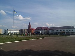
| image_caption = Downtown Olevsk |
||
| |
| image_flag = File:Flag of Olevsk.png |
||
| |
| image_shield = File:COA of Olevsk.png |
||
| shield_size = |
|||
|pushpin_map |
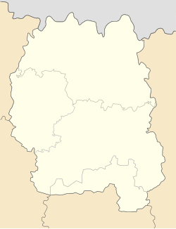
| pushpin_map = Ukraine Zhytomyr Oblast#Ukraine |
||
|pushpin_label_position = |
| pushpin_label_position = |
||
|pushpin_map_caption |
| pushpin_map_caption = |
||
|subdivision_type |
| subdivision_type = [[List of sovereign states|Country]] |
||
|subdivision_name |
| subdivision_name = {{flag|Ukraine}} |
||
|subdivision_type1 = [[Oblasts of Ukraine|Oblast]] |
|||
| |
| subdivision_type1 = [[Oblasts of Ukraine|Oblast]] |
||
| subdivision_name1 = [[Zhytomyr Oblast]] |
|||
|subdivision_type2 = [[Raions of Ukraine|Raion]] |
|||
| |
| subdivision_type2 = [[Raions of Ukraine|Raion]] |
||
| subdivision_name2 = [[Korosten Raion]] |
|||
|subdivision_type3 |
| subdivision_type3 = [[Hromada]] |
||
|subdivision_name3 |
| subdivision_name3 = [[Olevsk urban hromada]] |
||
|leader_title = |
|||
| |
| leader_title = |
||
| |
| leader_name = |
||
| established_title = |
|||
|established_date |
| established_date = |
||
|area_total_km2 |
| area_total_km2 = |
||
|population_as_of |
| population_as_of = 2022 |
||
|population_footnotes |
| population_footnotes = |
||
|population_total |
| population_total = 10032 |
||
|population_density_km2 |
| population_density_km2 = |
||
| ⚫ | |||
| |
| timezone = EET |
||
| |
| utc_offset = +2 |
||
| |
| timezone_DST = EEST |
||
| utc_offset_DST = +3 |
|||
|coordinates |
| coordinates = {{Coord|51|13|N|27|39|E|region:UA_type:city|display=title, inline}} |
||
|elevation_footnotes |
| elevation_footnotes = |
||
|elevation_m = |
|||
| |
| elevation_m = |
||
| |
| elevation_ft = |
||
| |
| website = |
||
| ⚫ | |||
}} |
}} |
||
'''Olevsk''' ({{ |
'''Olevsk''' ({{Langx|uk|Олевськ}}, {{IPA|uk|oˈlɛu̯sʲk|ipa|audio=LL-Q8798 (ukr)-Gzhegozh-Олевськ.wav}}; {{Langx|pl|Olewsk}}; {{langx|yi|אלעווסק}}) is a city in [[Korosten Raion]], [[Zhytomyr Oblast]], [[Ukraine]]. As of January 2022 its population was approximately {{Ua-pop-est2022|10,032|punct=.|showyear=false}} |
||
==History== |
==History== |
||
{{Historical affiliations |
{{Historical affiliations |
||
| float = left|{{flagicon image|Alex K Grundwald flags 1410-03.svg}} [[Grand Duchy of Lithuania]] (1488–1569)|{{flagicon image|Chorągiew królewska króla Zygmunta III Wazy.svg}} [[Polish–Lithuanian Commonwealth]] (1569–1793)|{{flag|Russian Empire}} (1793–1917)|{{flag|Ukrainian People's Republic}} (1917–1918)|{{flagicon image|Flag of Ukraine.svg}} [[Ukrainian State]] (1918)|{{flag|Ukrainian People's Republic}} (1918–1919)|{{flagicon image|Flag of Poland (1919–1928).svg}} [[Second Polish Republic|Republic of Poland]] (1919–1920){{cn|date=January 2024}}|{{flagicon image|Flag of the Ukrainian Soviet Socialist Republic (1919–1929).svg}} [[Soviet Ukraine]] (1920–1922)|{{flag|Soviet Union}} (1922–1991)|{{flag|Nazi Germany}} (1941–1944) (''[[Reichskommissariat Ukraine|occupation]]'')|{{flag|Ukraine}} (1991–present) |
|||
| float = left |
|||
| {{flagicon image|Alex K Grundwald flags 1410-03.svg}} [[Grand Duchy of Lithuania]] 1488–1569 |
|||
| {{flagicon image|Chorągiew królewska króla Zygmunta III Wazy.svg}} [[Polish–Lithuanian Commonwealth]] 1569–1793 |
|||
| {{flag|Russian Empire}} 1793–1917 |
|||
| {{flag|Ukrainian People's Republic}} 1917-1918 |
|||
| {{flagicon image|Flag of Ukraine.svg}} [[Ukrainian State]] 1918 |
|||
| {{flag|Ukrainian People's Republic}} 1918-1919 |
|||
| {{flagicon image|Flag of Poland (1919–1928).svg}} [[Second Polish Republic|Republic of Poland]] 1919–1920{{cn|date=January 2024}} |
|||
| {{flagicon image|Flag of the Ukrainian Soviet Socialist Republic (1919–1929).svg}} [[Soviet Ukraine]] 1920–1922 |
|||
| {{flag|Soviet Union}} 1922–1991 |
|||
| {{flag|Nazi Germany}} 1941–1944 (''[[Reichskommissariat Ukraine|occupation]]'') |
|||
| {{flag|Ukraine}} 1991–present |
|||
}} |
}} |
||
Olevsk was first mentioned in 1488. In 1641 Olevsk was granted [[Magdeburg city rights]] by Polish King [[Władysław IV Vasa]]. |
Olevsk was first mentioned in 1488. In 1641 Olevsk was granted [[Magdeburg city rights]] by Polish King [[Władysław IV Vasa]]. |
||
| Line 84: | Line 74: | ||
[[Category:Cities in Zhytomyr Oblast]] |
[[Category:Cities in Zhytomyr Oblast]] |
||
[[Category:Cities of district significance in Ukraine]] |
[[Category:Cities of district significance in Ukraine]] |
||
[[Category:Volhynian Voivodeship (1569–1795)]] |
|||
[[Category:Ovruchsky Uyezd]] |
|||
[[Category:Holocaust locations in Ukraine]] |
[[Category:Holocaust locations in Ukraine]] |
||
{{Zhytomyr-geo-stub}} |
{{Zhytomyr-geo-stub}} |
||
Latest revision as of 16:22, 16 December 2024
Olevsk
Олевськ | |
|---|---|
 Downtown Olevsk | |
| Coordinates: 51°13′N 27°39′E / 51.217°N 27.650°E | |
| Country | |
| Oblast | Zhytomyr Oblast |
| Raion | Korosten Raion |
| Hromada | Olevsk urban hromada |
| Population (2022) | |
• Total | 10,032 |
| Time zone | UTC+2 (EET) |
| • Summer (DST) | UTC+3 (EEST) |
Olevsk (Ukrainian: Олевськ, IPA: [oˈlɛu̯sʲk] ⓘ; Polish: Olewsk; Yiddish: אלעווסק) is a city in Korosten Raion, Zhytomyr Oblast, Ukraine. As of January 2022 its population was approximately 10,032.[1]
History
[edit] Grand Duchy of Lithuania (1488–1569)
 Polish–Lithuanian Commonwealth (1569–1793)
 Russian Empire (1793–1917)
 Ukrainian People's Republic (1917–1918)
 Ukrainian State (1918)
 Ukrainian People's Republic (1918–1919)
 Republic of Poland (1919–1920)[citation needed]
 Soviet Ukraine (1920–1922)
 Soviet Union (1922–1991)
 Nazi Germany (1941–1944) (occupation)
 Ukraine (1991–present)
Olevsk was first mentioned in 1488. In 1641 Olevsk was granted Magdeburg city rights by Polish King Władysław IV Vasa.
Later it became a town in Volhynian Governorate of the Russian Empire.
During World War II on November 15 or 21, 1941, members of Taras Bulba-Borovets' Ukrainian People's Revolutionary Army collaborated with the German administration in taking more than 500 Jews from Olevsk to Varvarivka, where they were murdered.[2]
On December 25, 2011, the city council of Olevsk renamed the streets of the city that bore the names of Soviet leaders, naming them in honor of prominent figures of the Ukrainian nationalist and patriotic movement. The streets and lanes named after Pavlo Postyshev, Stanislav Kosior, Hryhoriy Petrovsky, Mykhailo Kalinin, and Hryhoriy Kotovsky were renamed. Instead, they were named after Olena Teliha, Oleh Olzhych, Hetman Vyhovsky, Oleksiy Opanasiuk, Heroes of Kruty, the 20th anniversary of Ukraine's independence, and Yuriy Tiutiunnyk.[3]
Gallery
[edit]-
Ubort River in Olevsk
-
Olevsk railway station
-
Saint Nicholas monument
-
St. Nicholas Church
References
[edit]- ^ Чисельність наявного населення України на 1 січня 2022 [Number of Present Population of Ukraine, as of January 1, 2022] (PDF) (in Ukrainian and English). Kyiv: State Statistics Service of Ukraine. Archived (PDF) from the original on 4 July 2022.
- ^ McBride, Jared (July 20, 2016). "Ukrainian Holocaust Perpetrators Are Being Honored in Place of Their Victims". The Tablet. Retrieved July 22, 2016.
- ^ "На Житомирщині перейменували всі радянські назви вулиць". Archived from the original on 20 March 2014. Retrieved 4 January 2012.


