Cheruvathur: Difference between revisions
Appearance
Content deleted Content added
→External links: Added category Tags: Mobile edit Mobile web edit Advanced mobile edit |
Prajeeshkp99 (talk | contribs) m →top Tags: Mobile edit Mobile app edit Android app edit App full source |
||
| (10 intermediate revisions by 6 users not shown) | |||
| Line 1: | Line 1: | ||
{{Use dmy dates|date=May 2018}} |
{{Use dmy dates|date=May 2018}} |
||
{{Use Indian English|date=May 2018}} |
{{Use Indian English|date=May 2018}} |
||
{{unreferenced|date=January 2020}} |
|||
<!-- See [[Wikipedia:WikiProject Indian cities]] for details -->{{Infobox settlement |
<!-- See [[Wikipedia:WikiProject Indian cities]] for details -->{{Infobox settlement |
||
| name |
| name = Cheruvathur |
||
| other_name |
| other_name = |
||
| nickname |
| nickname = |
||
| settlement_type |
| settlement_type = Town |
||
| image_skyline |
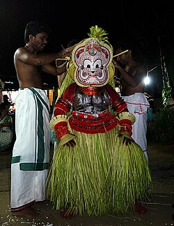
| image_skyline = File:Pottan Theyyam Cheruvathur.jpg |
||
| image_alt |
| image_alt = File:Salafi Mosque, Vellur (4601238430).jpg |
||
| image_caption |
| image_caption = Pottan [[Theyyam]] at Cheruvathur |
||
| pushpin_map |
| pushpin_map = India Kerala#India |
||
| pushpin_label_position |
| pushpin_label_position = right |
||
| pushpin_map_alt |
| pushpin_map_alt = |
||
| pushpin_map_caption |
| pushpin_map_caption = Location in Kerala, India |
||
| coordinates |
| coordinates = {{coord|12.2155977|N|75.1624288|E|display=inline,title}} |
||
| subdivision_type |
| subdivision_type = Country |
||
| subdivision_name |
| subdivision_name = {{flag|India}} |
||
| subdivision_type1 |
| subdivision_type1 = [[States and territories of India|State]] |
||
| subdivision_name1 |
| subdivision_name1 = [[Kerala]] |
||
| subdivision_type2 |
| subdivision_type2 = [[List of districts of India|District]] |
||
| subdivision_name2 |
| subdivision_name2 = [[Kasaragod district|Kasaragod]] |
||
| established_title |
| established_title = <!-- Established --> |
||
| established_date |
| established_date = |
||
| founder |
| founder = |
||
| named_for |
| named_for = |
||
| governing_body |
| governing_body = Cheruvathur Grama Panchayat |
||
| unit_pref |
| unit_pref = Metric |
||
| area_footnotes |
| area_footnotes = |
||
| area_rank |
| area_rank = |
||
| area_total_km2 |
| area_total_km2 = 18.37 |
||
| elevation_footnotes |
| elevation_footnotes = |
||
| elevation_m |
| elevation_m = |
||
| population_total |
| population_total = 27,435 |
||
| population_as_of |
| population_as_of = 2011 |
||
| population_rank |
| population_rank = |
||
| population_density_km2 |
| population_density_km2 = auto |
||
| population_demonym |
| population_demonym = |
||
| population_footnotes = <ref>{{Cite web |url=https://dop.lsgkerala.gov.in/en/node/1025 |title=Department of Panchayats - Government of Kerala |website=dop.lsgkerala.gov.in}}</ref> |
|||
| population_footnotes = |
|||
| demographics_type1 |
| demographics_type1 = Languages |
||
| demographics1_title1 |
| demographics1_title1 = Official |
||
| demographics1_info1 |
| demographics1_info1 = [[Malayalam language|Malayalam]], English |
||
| timezone1 |
| timezone1 = [[Indian Standard Time|IST]] |
||
| utc_offset1 |
| utc_offset1 = +5:30 |
||
| postal_code_type |
| postal_code_type = [[Postal Index Number|PIN]] |
||
| postal_code |
| postal_code = 671313 |
||
| registration_plate |
| registration_plate = |
||
| website |
| website = |
||
| footnotes |
| footnotes = |
||
}} |
}} |
||
'''Cheruvathur''' is a town in the [[Kasaragod district]], [[States and territories of India|state]] of [[Kerala]]. It is located |
'''Cheruvathur''' is a town and [[grama panchayat]] in the [[Kasaragod district]], [[States and territories of India|state]] of [[Kerala]]. It is located {{cvt|41|km|mi}} from the district headquarters [[Kasaragod]].<ref>{{Cite web |url=https://kasargod.nic.in/village-panchayats/ |title=Panchayats in Kasaragod}}</ref> |
||
==Transportation== |
==Transportation== |
||
| Line 65: | Line 64: | ||
[[Category:Cheruvathur area]] |
[[Category:Cheruvathur area]] |
||
[[Category: Cities and towns in Kasaragod district]] |
[[Category: Cities and towns in Kasaragod district]] |
||
[[Category:Panchayats in Kasaragod district]] |
|||
{{Kasaragod-geo-stub}} |
{{Kasaragod-geo-stub}} |
||
Latest revision as of 13:21, 17 December 2024
Cheruvathur | |
|---|---|
Town | |
 Pottan Theyyam at Cheruvathur | |
| Coordinates: 12°12′56″N 75°09′45″E / 12.2155977°N 75.1624288°E | |
| Country | |
| State | Kerala |
| District | Kasaragod |
| Government | |
| • Body | Cheruvathur Grama Panchayat |
| Area | |
• Total | 18.37 km2 (7.09 sq mi) |
| Population (2011)[1] | |
• Total | 27,435 |
| • Density | 1,500/km2 (3,900/sq mi) |
| Languages | |
| • Official | Malayalam, English |
| Time zone | UTC+5:30 (IST) |
| PIN | 671313 |
Cheruvathur is a town and grama panchayat in the Kasaragod district, state of Kerala. It is located 41 km (25 mi) from the district headquarters Kasaragod.[2]
Transportation
[edit]Local roads have access to NH-66 which connects to Mangalore in the north and Kannur in the south. The nearest railway station is Cheruvathur on Mangalore-Palakkad line. There are airports at Mangalore and Kannur.
References
[edit]- ^ "Department of Panchayats - Government of Kerala". dop.lsgkerala.gov.in.
- ^ "Panchayats in Kasaragod".
External links
[edit]Wikimedia Commons has media related to Cheruvathur.


