Kalety: Difference between revisions
Appearance
Content deleted Content added
m Bot: Migrating 1 interwiki links, now provided by Wikidata on d:q1001239 |
m →top: Format administrative division links, remove DEFAULTSORTKEY as per WP:SORTKEY, remove One Source for stubs, minor formatting changes (AWB) |
||
| (18 intermediate revisions by 13 users not shown) | |||
| Line 1: | Line 1: | ||
{{Infobox settlement |
{{Infobox settlement |
||
| name = Kalety |
| name = Kalety |
||
| image_flag = |
| image_flag = |
||
| image_shield = POL Kalety COA.svg |
| image_shield = POL Kalety COA.svg |
||
| image_skyline = Kościół Miotek (kalety)971.jpg |
| image_skyline = Kościół Miotek (kalety)971.jpg |
||
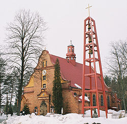
| image_caption = Saint Francis Church in Kalety-Miotek |
| image_caption = Saint Francis Church in Kalety-Miotek |
||
| pushpin_map = Poland |
| pushpin_map = Poland |
||
| ⚫ | |||
| coordinates_region = PL |
|||
| ⚫ | |||
| subdivision_name = {{POL}} |
| subdivision_name = {{POL}} |
||
| subdivision_type1 = [[Voivodeships of Poland|Voivodeship]] |
| subdivision_type1 = [[Voivodeships of Poland|Voivodeship]] |
||
| Line 16: | Line 15: | ||
| subdivision_name3 = Kalety <small>(urban gmina)</small> |
| subdivision_name3 = Kalety <small>(urban gmina)</small> |
||
| area_total_km2 = 57.68 |
| area_total_km2 = 57.68 |
||
| population_as_of = 2019-06-30<ref>{{cite web |title=Population. Size and structure and vital statistics in Poland by territorial division in 2019. As of 30th June|url=https://stat.gov.pl/en/topics/population/population/population-size-and-structure-and-vital-statistics-in-poland-by-territorial-division-in-2019-as-of-30th-june,3,26.html|website=stat.gov.pl|publisher=Statistics Poland|date=2019-10-15|access-date=2020-03-19}}</ref> |
|||
| population_as_of = 2006 |
|||
| population_total = |
| population_total = 8607 |
||
| population_density_km2 = auto |
| population_density_km2 = auto |
||
| ⚫ | |||
| latd = 50 | latm = 34 | lats = | latNS = N | longd = 18 | longm = 54 | longs = | longEW = E |
|||
| elevation_m = |
| elevation_m = |
||
| postal_code_type = Postal code |
| postal_code_type = Postal code |
||
| postal_code = 42-660 |
| postal_code = 42-660 |
||
| timezone = [[Central European Time|CET]] |
|||
| utc_offset = +1 |
|||
| timezone_DST = [[Central European Summer Time|CEST]] |
|||
| utc_offset_DST = +2 |
|||
| registration_plate = STA |
|||
| website = http://www.kalety.pl |
| website = http://www.kalety.pl |
||
}} |
|||
| website2 = http://kalety.eu }} |
|||
| ⚫ | |||
Kalety is a member of [[Cittaslow]]. |
|||
| ⚫ | |||
==Demographics== |
|||
| ⚫ | |||
{{Historical populations|align=left|1950|6699|1960|6653|2010|8681 |
|||
|source=<ref>{{cite book|author=<!--Staff writer(s); no by-line.-->|title=Dokumentacja Geograficzna|volume=3/4|year=1967|language=pl|location=Warszawa|publisher=Instytut Geografii [[Polish Academy of Sciences|Polskiej Akademii Nauk]]|page=18}}</ref><ref>{{cite book|author=<!--Staff writer(s); no by-line.-->|url=https://stat.gov.pl/cps/rde/xbcr/gus/PUBL_l_ludnosc_stan_struktura_31_12_2010.pdf|title=Stan i struktura ludności oraz ruch naturalny w przekroju terytorialnym w 2010 r.|year=2011|language=pl|location=Warszawa|publisher=Główny Urząd Statystyczny|page=94|archive-url=https://web.archive.org/web/20111113152513/https://stat.gov.pl/cps/rde/xbcr/gus/PUBL_l_ludnosc_stan_struktura_31_12_2010.pdf|archive-date=13 November 2011}}</ref>}} |
|||
{{clear|left}} |
|||
==Twin towns – sister cities== |
|||
| ⚫ | |||
{{See also|List of twin towns and sister cities in Poland}} |
|||
Kalety is [[Sister city|twinned]] with:<ref>{{cite web |title=Miasta Partnerskie|url=http://kalety.pl/Miasta_Partnerskie-32-32.html|website=kalety.pl|publisher=Kalety|language=pl|access-date=2020-03-19}}</ref> |
|||
*{{flagicon|POL}} [[Ustroń]], Poland |
|||
*{{flagicon|CZE}} [[Vítkov (Opava District)|Vítkov]], Czech Republic |
|||
==References== |
|||
| ⚫ | |||
{{reflist}} |
|||
| ⚫ | |||
| ⚫ | |||
{{Authority control}} |
|||
[[Category:Cities and towns in Silesian Voivodeship]] |
[[Category:Cities and towns in Silesian Voivodeship]] |
||
[[Category:Tarnowskie Góry County]] |
[[Category:Tarnowskie Góry County]] |
||
[[Category:Cittaslow]] |
|||
{{TarnowskieGóry-geo-stub}} |
{{TarnowskieGóry-geo-stub}} |
||
Latest revision as of 07:55, 19 December 2024
Kalety | |
|---|---|
 Saint Francis Church in Kalety-Miotek | |
| Coordinates: 50°34′N 18°54′E / 50.567°N 18.900°E | |
| Country | |
| Voivodeship | Silesian |
| County | Tarnowskie Góry |
| Gmina | Kalety (urban gmina) |
| Area | |
• Total | 57.68 km2 (22.27 sq mi) |
| Population (2019-06-30[1]) | |
• Total | 8,607 |
| • Density | 150/km2 (390/sq mi) |
| Time zone | UTC+1 (CET) |
| • Summer (DST) | UTC+2 (CEST) |
| Postal code | 42-660 |
| Vehicle registration | STA |
| Website | http://www.kalety.pl |
Kalety [kaˈlɛtɨ] (German: Kalet, Stahlhammer (1940–45); Silesian: Kalyty) is a town in Tarnowskie Góry County, Silesian Voivodeship, Poland, with 8,607 inhabitants (2019).
Kalety is a member of Cittaslow.
Demographics
[edit]| Year | Pop. | ±% |
|---|---|---|
| 1950 | 6,699 | — |
| 1960 | 6,653 | −0.7% |
| 2010 | 8,681 | +30.5% |
| Source: [2][3] | ||
Twin towns – sister cities
[edit]References
[edit]- ^ "Population. Size and structure and vital statistics in Poland by territorial division in 2019. As of 30th June". stat.gov.pl. Statistics Poland. 2019-10-15. Retrieved 2020-03-19.
- ^ Dokumentacja Geograficzna (in Polish). Vol. 3/4. Warszawa: Instytut Geografii Polskiej Akademii Nauk. 1967. p. 18.
- ^ Stan i struktura ludności oraz ruch naturalny w przekroju terytorialnym w 2010 r. (PDF) (in Polish). Warszawa: Główny Urząd Statystyczny. 2011. p. 94. Archived from the original (PDF) on 13 November 2011.
- ^ "Miasta Partnerskie". kalety.pl (in Polish). Kalety. Retrieved 2020-03-19.
Wikimedia Commons has media related to Kalety.


