Bot, Spain: Difference between revisions
update mayor |
No edit summary Tags: Visual edit Mobile edit Mobile web edit |
||
| (26 intermediate revisions by 18 users not shown) | |||
| Line 1: | Line 1: | ||
{{Infobox settlement |
{{Infobox settlement |
||
| name |
| name = Bot |
||
| settlement_type |
| settlement_type = [[Municipalities of Catalonia|Municipality]] |
||
| image_skyline |
| image_skyline = File:Bot, Terra Alta.jpg |
||
| image_alt |
| image_alt = |
||
| image_caption |
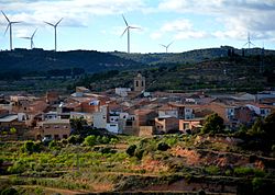
| image_caption = General view of Bot |
||
| image_flag |
| image_flag = |
||
| flag_alt |
| flag_alt = |
||
| image_seal |
| image_seal = |
||
| seal_alt |
| seal_alt = |
||
| image_shield |
| image_shield = |
||
| shield_alt |
| shield_alt = |
||
| nickname |
| nickname = |
||
| motto |
| motto = |
||
| image_map |
| image_map = |
||
| map_alt |
| map_alt = |
||
| map_caption |
| map_caption = |
||
| pushpin_map |
| pushpin_map = Spain Catalonia |
||
| pushpin_label_position |
| pushpin_label_position = |
||
| pushpin_map_alt |
| pushpin_map_alt = |
||
| pushpin_map_caption |
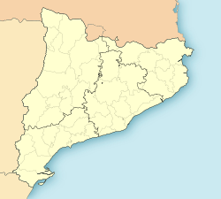
| pushpin_map_caption = Location in Catalonia |
||
| coordinates = {{coord|41|0|N|0|23|E|display=inline,title}} |
|||
| latd = 41 |latm = 0 |lats = |latNS = N |
|||
| ⚫ | |||
| longd = 0 |longm = 23 |longs = |longEW = E |
|||
| ⚫ | |||
| ⚫ | |||
| subdivision_type = [[List of sovereign states|Country]] |
|||
| ⚫ | |||
| ⚫ | |||
| coordinates_display = inline,title |
|||
| ⚫ | |||
| ⚫ | |||
| ⚫ | |||
| coordinates_region = |
|||
| |
| subdivision_type2 = [[Provinces of Spain|Province]] |
||
| ⚫ | |||
| ⚫ | |||
| ⚫ | |||
| ⚫ | |||
| subdivision_name3 = [[Terra Alta (comarca)|Terra Alta]] |
|||
| ⚫ | |||
| established_title = |
|||
| subdivision_type2 = [[Provinces of Spain|Province]] |
|||
| ⚫ | |||
| ⚫ | |||
| ⚫ | |||
| ⚫ | |||
| |
| seat_type = |
||
| |
| seat = |
||
| government_footnotes = |
|||
| ⚫ | |||
| |
| leader_party = |
||
| |
| leader_title = [[Alcalde]] |
||
| |
| leader_name = Núria Mulet Mulet |
||
| |
| unit_pref = Metric |
||
| leader_party = |
|||
| leader_title = [[Mayor]] |
|||
| leader_name = Lluís Andrés Agut Solé (2015)<ref name=municat>{{cite web|url=http://municat.gencat.cat/index.php?page=consulta&mostraEns=4303260009|title=Ajuntament de Bot|publisher=[[Generalitat of Catalonia]]|accessdate=2015-11-13}}</ref> |
|||
| unit_pref = Metric |
|||
<!-- ALL fields with measurements have automatic unit conversion --> |
<!-- ALL fields with measurements have automatic unit conversion --> |
||
<!-- for references: use <ref> tags -->| area_footnotes = <ref name=idescat>{{cite web|url=http://www.idescat.cat/emex/?lang=en&id=430326|title=El municipi en xifres: Bot|publisher=[[Institut d'Estadística de Catalunya|Statistical Institute of Catalonia]]|access-date=2015-11-23}}</ref> |
|||
<!-- for references: use <ref> tags --> |
|||
| area_urban_footnotes = <!-- <ref> </ref> --> |
|||
| area_footnotes = |
|||
| |
| area_rural_footnotes = <!-- <ref> </ref> --> |
||
| |
| area_metro_footnotes = <!-- <ref> </ref> --> |
||
| |
| area_magnitude = <!-- <ref> </ref> --> |
||
| |
| area_note = |
||
| area_water_percent = |
|||
| area_note = |
|||
| |
| area_rank = |
||
| |
| area_blank1_title = |
||
| ⚫ | |||
| area_blank1_title = |
|||
| |
| area_total_km2 = 34.9 |
||
| area_land_km2 = |
|||
| ⚫ | |||
| |
| area_water_km2 = |
||
| |
| area_urban_km2 = |
||
| |
| area_rural_km2 = |
||
| |
| area_metro_km2 = |
||
| |
| area_blank1_km2 = |
||
| |
| area_blank2_km2 = |
||
| dimensions_footnotes = |
|||
| area_blank1_km2 = |
|||
| ⚫ | |||
| area_blank2_km2 = |
|||
| |
| elevation_m = |
||
| population_as_of = {{Spain metadata Wikidata|population_as_of}} |
|||
| ⚫ | |||
| population_footnotes = {{Spain metadata Wikidata|population_footnotes}} |
|||
| elevation_m = |
|||
| population_total = {{Spain metadata Wikidata|population_total}} |
|||
| population_footnotes = |
|||
| ⚫ | |||
| population_total = 793 |
|||
| population_demonym = |
|||
| population_as_of = 2003 |
|||
| population_note = |
|||
| ⚫ | |||
| |
| postal_code_type = |
||
| |
| postal_code = |
||
| area_code_type = |
|||
| timezone1 = [[Central European Time|CET]] |
|||
| |
| area_code = |
||
| |
| iso_code = |
||
| blank_name = [[Köppen climate classification|Climate]] |
|||
| utc_offset1_DST = +2 |
|||
| blank_info = [[Mediterranean climate#Hot-summer mediterranean climate|Csa]] |
|||
| postal_code_type = |
|||
| |
| website = {{url|www.bot.altanet.org}} |
||
| |
| footnotes = |
||
| area_code = |
|||
| iso_code = |
|||
| website = <!-- {{URL|example.com}} --> |
|||
| footnotes = |
|||
}} |
}} |
||
'''Bot''' is a |
'''Bot''' ({{IPA|ca|ˈbɔt}}) is a town located in the ''[[Comarques of Catalonia|comarca]]'' of [[Terra Alta (comarca)|Terra Alta]], province of [[Tarragona]], in [[Catalonia]], Spain. It is located between the Serra de la Solsida and the [[Serra dels Pesells]] ranges. In 2003 Bot had a total population of 793. |
||
The people in the town of Bot have been traditionally engaged in [[wine]] production. |
The people in the town of Bot have been traditionally engaged in [[wine]] production. |
||
There was a [[ |
There was a [[Renfe]] railway line from [[Tortosa]] to [[Alcañiz]] and [[Zaragoza]] that used to pass through Bot until 1973.<ref>[http://www.vilaweb.cat/www/elpunt/noticia?p_idcmp=3504938 El Punt - El cruel divorci entre Tortosa i el tren]</ref> This line was dismantled as a result of a 1962 [[World Bank]] report advising the [[Spanish State]] to concentrate investment in the great lines and to abandon the less profitable railways connecting rural areas. Since the line was terminated, the rails were pulled off and the Bot [[train station]] buildings lie abandoned. The train was affectionately known as "el tramvia" ([[Tram|the tramway]]) by locals. |
||
==References== |
==References== |
||
{{ |
{{Reflist}} |
||
==External links== |
==External links== |
||
{{Commons category|Bot, Tarragona}} |
{{Commons category|Bot, Tarragona}} |
||
*[http://www.bot.altanet.org/ Official Website] {{ |
*[http://www.bot.altanet.org/ Official Website] {{in lang|ca}} |
||
* [http://aplicacions.municat.gencat.cat/index.php?page=consulta&mostraEns=4303260009 Government data pages] {{in lang|ca}} |
|||
{{br}} |
|||
{{Geographic location |
{{Geographic location |
||
|Centre = Bot |
|Centre = Bot |
||
| Line 115: | Line 107: | ||
{{Terra Alta}} |
{{Terra Alta}} |
||
{{Municipalities in Tarragona|state=autocollapse}} |
{{Municipalities in Tarragona|state=autocollapse}} |
||
{{Authority control}} |
|||
| ⚫ | |||
| ⚫ | |||
{{Tarragona-geo-stub}} |
{{Tarragona-geo-stub}} |
||
Latest revision as of 20:32, 24 December 2024
Bot | |
|---|---|
 General view of Bot | |
| Coordinates: 41°0′N 0°23′E / 41.000°N 0.383°E | |
| Country | |
| Community | |
| Province | |
| Comarca | Terra Alta |
| Government | |
| • Alcalde | Núria Mulet Mulet |
| Area | |
• Total | 34.9 km2 (13.5 sq mi) |
| Population (2018)[2] | |
• Total | 601 |
| • Density | 17/km2 (45/sq mi) |
| Climate | Csa |
| Website | www |
Bot (Catalan pronunciation: [ˈbɔt]) is a town located in the comarca of Terra Alta, province of Tarragona, in Catalonia, Spain. It is located between the Serra de la Solsida and the Serra dels Pesells ranges. In 2003 Bot had a total population of 793.
The people in the town of Bot have been traditionally engaged in wine production.
There was a Renfe railway line from Tortosa to Alcañiz and Zaragoza that used to pass through Bot until 1973.[3] This line was dismantled as a result of a 1962 World Bank report advising the Spanish State to concentrate investment in the great lines and to abandon the less profitable railways connecting rural areas. Since the line was terminated, the rails were pulled off and the Bot train station buildings lie abandoned. The train was affectionately known as "el tramvia" (the tramway) by locals.
References
[edit]- ^ "El municipi en xifres: Bot". Statistical Institute of Catalonia. Retrieved 2015-11-23.
- ^ Municipal Register of Spain 2018. National Statistics Institute.
- ^ El Punt - El cruel divorci entre Tortosa i el tren
External links
[edit]- Official Website (in Catalan)
- Government data pages (in Catalan)

