Līvāni Municipality: Difference between revisions
Appearance
Content deleted Content added
m robot Adding: ru:Ливанский край |
No edit summary |
||
| (40 intermediate revisions by 31 users not shown) | |||
| Line 1: | Line 1: | ||
{{short description|Municipality of Latvia}} |
|||
{{Infobox Latvian municipalities |
|||
{{Infobox settlement |
|||
| name = Līvāni municipality<br/>''Līvānu novads'' |
|||
| |
| name = Līvāni Municipality |
||
| |
| native_name = ''Līvānu novads'' |
||
| |
| native_name_lang = lv |
||
| |
| official_name = |
||
| ⚫ | |||
| name_coat_of_arms = |
|||
| image_flag = Flag of Līvānu novads.svg |
|||
| coat_of_arms_width= |
|||
| |
| flag_alt = Unofficial flag of the municipality |
||
| |
| image_shield = Līvānu novads COA.svg |
||
| |
| image_seal = |
||
| image_map = Latvija Līvānu novads 2021.svg |
|||
| area = 624,6<ref>[http://www.raplm.gov.lv/uploads/filedir/Nozares/Pasvaldibas/Administrat%C4%ABvi%20teritori%C4%81lais%20iedal%C4%ABjum%20ar%20platibu.doc The Ministry of Regional Development and Local Government of the Republic of Latvia]</ref> |
|||
| map_caption = |
|||
| population = 14.292<ref>[http://web.cvk.lv/pub/public/29275.html The Central Election Commission of Latvia]</ref> |
|||
| |
| coordinates = |
||
| |
| subdivision_type = Country |
||
| |
| subdivision_name = {{LVA}} |
||
| established_title = Formed |
|||
| mayor = Andris Vaivods |
|||
| |
| established_date = 1999 |
||
| |
| seat_type = Centre |
||
| seat = [[Līvāni]] |
|||
| leader_title = Council Chair |
|||
| leader_name = Andris Vaivods ([[Latvian Farmers' Union|LZS]]) |
|||
| area_footnotes = {{wikidata|reference|best||P2046|P518=Q16868672}} |
|||
| area_total_km2 = {{#invoke:wd|properties|raw|qualifiers|best|raw||P2046|P518=Q16868672}} |
|||
| area_land_km2 = {{#invoke:wd|properties|raw|qualifiers|best|raw||P2046|P518=Q11081619}} |
|||
| area_water_km2 = {{#expr:{{#invoke:wd|properties|raw|qualifiers|best|raw||P2046|P518=Q16868672}}-{{#invoke:wd|properties|raw|qualifiers|best|raw||P2046|P518=Q11081619}}}} |
|||
| population_footnotes = {{wikidata|references|best||P1082}} |
|||
| population_total = {{wikidata|property|qualifier|best||P1082}} |
|||
| population_as_of = {{#invoke:WikidataIB|formatDate|{{wikidata|qualifier|best|raw||P1082|P585}}|df=y}} |
|||
| population_density_km2 = auto |
|||
| postal_code_type = Postal code |
|||
| postal_code = |
|||
| image_map1 = Līvānu novads 2021.png |
|||
| website = {{URL|www.livani.lv}} |
|||
}} |
}} |
||
'''Līvāni |
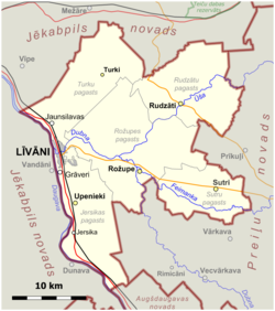
'''Līvāni Municipality''' ({{langx|lv|Līvānu novads}}, {{langx|ltg|Leivuona nūvods}}) is a [[municipality]] in [[Latgale]], [[Latvia]]. The municipality was formed in 1999 by [[Merger (politics)|merging]] [[Rožupe Parish]], [[Turki Parish]] and [[Līvāni]] [[town]]. In 2009 it absorbed [[Jersika Parish]], [[Rudzāti Parish]] and [[Sutri Parish]], the administrative centre being Līvāni. |
||
== See also == |
|||
| ⚫ | |||
== References == |
== References == |
||
{{reflist}} |
{{reflist}} |
||
{{Līvāni Municipality}} |
|||
{{Latvian municipalities 2009}} |
|||
{{Latgale Region}} |
|||
{{Administrative divisions of Latvia}} |
|||
{{coord|56|22|N|26|11|E|source:kolossus-itwiki|display=title}} |
|||
{{Authority control}} |
|||
{{coord missing|Latvia}} |
|||
{{DEFAULTSORT:Livani Municipality}} |
{{DEFAULTSORT:Livani Municipality}} |
||
[[Category:Līvāni Municipality| ]] |
|||
[[Category:Municipalities of Latvia]] |
[[Category:Municipalities of Latvia]] |
||
{{latgale-geo-stub}} |
{{latgale-geo-stub}} |
||
[[es:Municipalidad de Līvāni]] |
|||
[[lv:Līvānu novads]] |
|||
[[lt:Lyvanų savivaldybė]] |
|||
[[mk:Ливани (општина)]] |
|||
[[pl:Līvānu novads]] |
|||
[[ru:Ливанский край]] |
|||
Latest revision as of 10:17, 27 December 2024
Līvāni Municipality
Līvānu novads | |
|---|---|
 | |
 | |
| Country | |
| Formed | 1999 |
| Centre | Līvāni |
| Government | |
| • Council Chair | Andris Vaivods (LZS) |
| Area | |
• Total | 622.57 km2 (240.38 sq mi) |
| • Land | 606.51 km2 (234.17 sq mi) |
| • Water | 16.06 km2 (6.20 sq mi) |
| Population (2024)[2] | |
• Total | 10,215 |
| • Density | 16/km2 (42/sq mi) |
| Website | www |
Līvāni Municipality (Latvian: Līvānu novads, Latgalian: Leivuona nūvods) is a municipality in Latgale, Latvia. The municipality was formed in 1999 by merging Rožupe Parish, Turki Parish and Līvāni town. In 2009 it absorbed Jersika Parish, Rudzāti Parish and Sutri Parish, the administrative centre being Līvāni.
References
[edit]- ^ "Reģionu, novadu, pilsētu un pagastu kopējā un sauszemes platība gada sākumā". Central Statistical Bureau of Latvia. Retrieved 30 July 2024.
- ^ "Iedzīvotāju skaits pēc tautības reģionos, pilsētās, novados, pagastos, apkaimēs un blīvi apdzīvotās teritorijās gada sākumā (pēc administratīvi teritoriālās reformas 2021. gadā)". Central Statistical Bureau of Latvia. Retrieved 19 June 2024.
56°22′N 26°11′E / 56.367°N 26.183°E


