Abu al-Duhur Subdistrict: Difference between revisions
Appearance
Content deleted Content added
tweaked; tagged; trimmed |
added new flag |
||
| (10 intermediate revisions by 8 users not shown) | |||
| Line 1: | Line 1: | ||
{{one source|date=March 2016}} |
|||
{{onesource}} |
|||
{{Infobox settlement |
{{Infobox settlement |
||
<!--See the Table at Infobox Settlement for all fields and descriptions of usage--> |
<!--See the Table at Infobox Settlement for all fields and descriptions of usage--> |
||
|official_name = Abu al-Duhur |
|official_name = Abu al-Duhur Subdistrict |
||
|native_name = '''ناحية أبو الظهور''' |
|native_name = '''ناحية أبو الظهور''' |
||
|native_name_lang = ar |
|native_name_lang = ar |
||
| Line 15: | Line 15: | ||
|pushpin_mapsize = 250 |
|pushpin_mapsize = 250 |
||
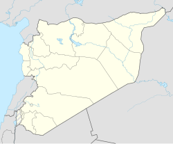
|pushpin_map_caption = Location in Syria |
|pushpin_map_caption = Location in Syria |
||
|coordinates_region = SY |
|||
|subdivision_type = Country |
|subdivision_type = Country |
||
|subdivision_name = {{ |
|subdivision_name = {{flagicon image|Flag of the Syrian revolution.svg}} [[Syria]] |
||
|subdivision_type1 = [[Governorates of Syria|Governorate]] |
|subdivision_type1 = [[Governorates of Syria|Governorate]] |
||
|subdivision_name1 = [[Idlib Governorate|Idlib]] |
|subdivision_name1 = [[Idlib Governorate|Idlib]] |
||
| Line 33: | Line 32: | ||
|timezone_DST = [[Eastern European Summer Time|EEST]] |
|timezone_DST = [[Eastern European Summer Time|EEST]] |
||
|utc_offset_DST = +3 |
|utc_offset_DST = +3 |
||
|coordinates = {{coord|display=inline,title}} |
|||
|latd=|latm=|lats=|latNS=N |
|||
|longd=|longm=|longs=|longEW=E |
|||
|coordinates_display = inline,title |
|||
|blank_name_sec1 = Nahya pcod |
|blank_name_sec1 = Nahya pcod |
||
|blank_info_sec1 = SY070001 |
|blank_info_sec1 = SY070001 |
||
}} |
}} |
||
'''Abu al-Duhur |
'''Abu al-Duhur Subdistrict''' ({{langx|ar|ناحية أبو الظهور}}) is a Syrian ''[[nahiyah]]'' (subdistrict) located in [[Idlib District]] in [[Idlib Governorate|Idlib]]. According to the [[Central Bureau of Statistics (Syria)|Syria Central Bureau of Statistics]] (CBS), Abu al-Duhur Subdistrict had a population of 38,869 in the 2004 census.<ref>{{cite web|title=General Census of Population 2004.|url=https://www.humanitarianresponse.info/sites/www.humanitarianresponse.info/files/syr_pop_2004_sycensus_0.xls}}</ref> |
||
==References== |
==References== |
||
{{reflist}} |
{{reflist}} |
||
{{Portal| |
{{Portal|Asia}} |
||
{{Subdistricts of Idlib}} |
{{Subdistricts of Idlib}} |
||
{{coord missing|Syria}} |
|||
[[Category:Subdistricts of Idlib Governorate]] |
[[Category:Subdistricts of Idlib Governorate]] |
||
{{IdlibSY-geo-stub}} |
{{IdlibSY-geo-stub}} |
||
Latest revision as of 22:03, 29 December 2024
This article relies largely or entirely on a single source. (March 2016) |
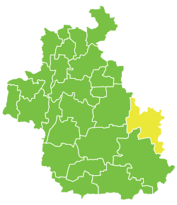
Abu al-Duhur Subdistrict
ناحية أبو الظهور | |
|---|---|
Nahiyah | |
 Location in Idlib Governorate | |
| Coordinates: 35°45′22″N 37°01′23″E / 35.7561°N 37.0231°E | |
| Country | |
| Governorate | Idlib |
| District | Idlib District |
| Population (2004) | |
• Total | 38,869 |
| Time zone | UTC+2 (EET) |
| • Summer (DST) | UTC+3 (EEST) |
| Nahya pcod | SY070001 |
Abu al-Duhur Subdistrict (Arabic: ناحية أبو الظهور) is a Syrian nahiyah (subdistrict) located in Idlib District in Idlib. According to the Syria Central Bureau of Statistics (CBS), Abu al-Duhur Subdistrict had a population of 38,869 in the 2004 census.[1]
References
[edit]

