Nagyigmánd: Difference between revisions
Appearance
Content deleted Content added
Content Tags: Mobile edit Mobile web edit |
Tags: Mobile edit Mobile web edit |
||
| (3 intermediate revisions by the same user not shown) | |||
| Line 38: | Line 38: | ||
==Sights== |
==Sights== |
||
There are two churches in this village, a Catholic one and a Protestant one (the latter belongs to the Hungarian Reformed Church). |
There are two churches in this village, a Catholic one and a Protestant one (the latter belongs to the Hungarian Reformed Church).<ref>{{Cite web |title=Official website |url=http://nagyigmand.hu/latnivalok.php}}</ref> |
||
[[File:Nagyigmánd, római katolikus templom 2024 01.jpg|thumb|Catholic Church of St. Michael.]] |
|||
[[File:Nagyigmánd, református templom.jpg|thumb|Reformed Church.]] |
|||
[[File:Nagyigmánd57.JPG|thumb|Memorial for the fallen soldiers of World War II.]] |
|||
==References== |
==References== |
||
Latest revision as of 19:19, 7 January 2025
Nagyigmánd | |
|---|---|
Large village | |
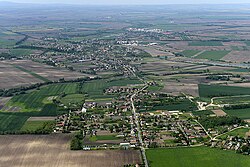
 Aerial view | |
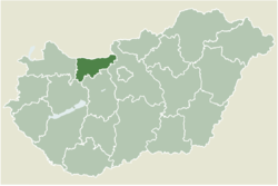
 Location of Komárom-Esztergom county in Hungary | |
| Coordinates: 47°37′57″N 18°03′20″E / 47.63253°N 18.05569°E | |
| Country | |
| County | Komárom-Esztergom |
| District | Komárom |
| Area | |
• Total | 51.39 km2 (19.84 sq mi) |
| Population (2004) | |
• Total | 3,166 |
| • Density | 61.6/km2 (160/sq mi) |
| Time zone | UTC+1 (CET) |
| • Summer (DST) | UTC+2 (CEST) |
| Postal code | 2942 |
| Area code | (+36) 34 |
| Website | http://nagyigmand.hu/ |
Nagyigmánd is a village in Komárom-Esztergom county, Hungary. It is the site of an ancient earthwork fort.

Sights
[edit]There are two churches in this village, a Catholic one and a Protestant one (the latter belongs to the Hungarian Reformed Church).[1]


References
[edit]External links
[edit]![]() Media related to Nagyigmánd at Wikimedia Commons
Media related to Nagyigmánd at Wikimedia Commons
- Official website in Hungarian
- Street map (Hungarian)


