Pujali: Difference between revisions
No edit summary Tags: Mobile edit Mobile web edit |
No edit summary Tags: Mobile edit Mobile web edit |
||
| (6 intermediate revisions by the same user not shown) | |||
| Line 1: | Line 1: | ||
{{Short description| |
{{Short description|City in West Bengal, India}} |
||
{{Use dmy dates|date=October 2019}} |
{{Use dmy dates|date=October 2019}} |
||
{{Use Indian English|date=June 2017}} |
{{Use Indian English|date=June 2017}} |
||
{{Infobox settlement |
{{Infobox settlement |
||
| name = Pujali |
| name = Pujali |
||
| native_name = |
| native_name = |
||
| native_name_lang = |
| native_name_lang = |
||
| other_name = |
| other_name = |
||
| |
| settlement_type = [[Cities and towns in West Bengal|City]] |
||
| |
| image_skyline = Pujali Municipality.jpg |
||
| |
| imagesize = 300px |
||
| |
| image_caption = Pujali Municipality |
||
| ⚫ | |||
| ⚫ | |||
| |
| map_caption = Interactive map outlining Pujali |
||
| pushpin_map = India West Bengal#India#Asia#Earth |
|||
| ⚫ | |||
| |
| pushpin_mapsize = 300 |
||
| |
| pushpin_map_caption = Location in West Bengal##Location in India##Location in Asia##Location in Earth |
||
| ⚫ | |||
| pushpin_label_position = |
|||
| |
| subdivision_type = [[List of sovereign states|Country]] |
||
| |
| subdivision_name = {{flag|India}} |
||
| |
| subdivision_type1 = [[States and union territories of India|State]] |
||
| ⚫ | |||
| ⚫ | |||
| subdivision_type2 = [[Administrative divisions of West Bengal|Division]] |
|||
| subdivision_type = Country |
|||
| |
| subdivision_name2 = [[Presidency division|Presidency]] |
||
| ⚫ | |||
| subdivision_type1 = State |
|||
| ⚫ | |||
| ⚫ | |||
| |
| established_title = <!-- Established --> |
||
| established_date = |
|||
| subdivision_name2 = [[Presidency division|Presidency]] |
|||
| ⚫ | |||
| ⚫ | |||
| governing_body = Pujali Municipality |
|||
| ⚫ | |||
| |
| leader_title = |
||
| ⚫ | |||
| subdivision_name4 = [[Kolkata metropolitan area|Greater Kolkata]] |
|||
| |
| unit_pref = Metric |
||
| |
| area_total_km2 = 8.32 |
||
| |
| area_footnotes = |
||
| |
| area_metro_km2 = |
||
| area_metro_footnotes = |
|||
| ⚫ | |||
| |
| elevation_m = 8 |
||
| |
| elevation_footnotes = |
||
| |
| population_as_of = 2011 |
||
| |
| population_total = 37,047 |
||
| |
| population_density_km2 = auto |
||
| |
| population_footnotes = |
||
| |
| population_metro = |
||
| population_density_metro_km2 = auto |
|||
| population_total = 37047 |
|||
| population_metro_footnotes = |
|||
| population_as_of = 2011 |
|||
| |
| population_demonym = |
||
| ⚫ | |||
| population_density_km2 = auto |
|||
| ⚫ | |||
| population_demonym = |
|||
| demographics1_info1 = 78.80 per cent |
|||
| population_footnotes = |
|||
| ⚫ | |||
| ⚫ | |||
| demographics1_info2 = 956 [[male|♂]]/[[female|♀]] |
|||
| ⚫ | |||
| demographics_type2 = Languages |
|||
| ⚫ | | |
||
| demographics2_title1 = Official |
|||
| ⚫ | |||
| ⚫ | | demographics2_info1 = [[Bengali language|Bengali]]<ref name="wblangoff">{{cite web|title=Fact and Figures|url=https://wb.gov.in/portal/web/guest/facts-and-figures;jsessionid=JzdD9RHb7aMY5esZPtcsIVLy|website=Wb.gov.in|access-date=5 July 2019}}</ref><ref>{{cite web|title=52nd Report of the Commissioner for Linguistic Minorities in India|url=http://nclm.nic.in/shared/linkimages/NCLM52ndReport.pdf|website=Nclm.nic.in|publisher=[[Ministry of Minority Affairs]]|access-date=5 July 2019|page=85|url-status=dead|archive-url=https://web.archive.org/web/20170525141614/http://nclm.nic.in/shared/linkimages/NCLM52ndReport.pdf|archive-date=25 May 2017}}</ref> |
||
| ⚫ | |||
| |
| demographics2_title2 = Additional official |
||
| ⚫ | |||
| ⚫ | |||
| |
| timezone1 = [[Indian Standard Time|IST]] |
||
| |
| utc_offset1 = +5:30 |
||
| |
| postal_code_type = [[Postal Index Number|PIN]] |
||
| |
| postal_code = 700138 |
||
| area_code_type = [[Telephone numbers in India|Telephone code]] |
|||
| ⚫ | | registration_plate = [[List of Regional Transport Office districts in India# |
||
| |
| area_code = +91 33 |
||
| ⚫ | | registration_plate = [[List of Regional Transport Office districts in India#WB—West Bengal|WB-19]], [[List of Regional Transport Office districts in India#WB—West Bengal|WB-20]], [[List of Regional Transport Office districts in India#WB—West Bengal|WB-95]], [[List of Regional Transport Office districts in India#WB—West Bengal|WB-96]], [[List of Regional Transport Office districts in India#WB—West Bengal|WB-97]], [[List of Regional Transport Office districts in India#WB—West Bengal|WB-98]] |
||
| blank1_info_sec1 = [[Diamond Harbour (Lok Sabha constituency)|Diamond Harbour]] |
|||
| |
| blank1_name_sec1 = [[List of constituencies of the Lok Sabha|Lok Sabha constituency]] |
||
| |
| blank1_info_sec1 = [[Diamond Harbour Lok Sabha constituency|Diamond Harbour]] |
||
| blank2_name_sec1 = [[List of constituencies of the West Bengal Legislative Assembly|Vidhan Sabha constituency]] |
|||
| ⚫ | |||
| |
| blank2_info_sec1 = [[Budge Budge Assembly constituency|Budge Budge]] |
||
| ⚫ | |||
| ⚫ | |||
}} |
}} |
||
'''Pujali''' ({{IPA|bn|puːd͡ʒɑːlɪ|lang|LL-Q9610 (ben)-Titodutta-পূজালি.wav}}) is a |
'''Pujali''' ({{IPA|bn|puːd͡ʒɑːlɪ|lang|LL-Q9610 (ben)-Titodutta-পূজালি.wav}}) is a city and a municipality of the [[South 24 Parganas|South 24 Parganas district]] in the [[India]]n [[States and union territories of India|state]] of [[West Bengal]]. It is a part of the area covered by [[Kolkata Metropolitan Development Authority]] (KMDA).<ref>{{cite web|url=http://www.cmdaonline.com/kma.html|title=Base Map of Kolkata Metropolitan Area|access-date=3 September 2007|publisher=Kolkata Metropolitan Development Authority|url-status=dead|archive-url=https://web.archive.org/web/20070928000049/http://www.cmdaonline.com/kma.html|archive-date=28 September 2007}}</ref> |
||
==Geography== |
==Geography== |
||
| Line 190: | Line 192: | ||
}} |
}} |
||
According to the [[2011 Census of India]], Pujali had a total population of 37,047, of which 18,940 were males and 18,107 were females. There were 4,316 |
According to the [[2011 Census of India]], Pujali had a total population of 37,047, of which 18,940 (51%) were males and 18,107 (49%) were females. It had a population density of {{convert|4453|PD/sqkm|PD/sqmi}} with a sex ratio of 956 females for every 1000 males. There were 4,316 persons in the age range of 0 to 6 years. The Scheduled Castes numbered 5,480 (14.79%) and the Scheduled Tribes numbered 937 (2.53%). The total number of literate persons was 25,791 (78.80% of the population over 6 years) out of which males numbered 13,827 (82.59% of the male population over 6 years) and females numbered 11,964 (74.82% of the female population over 6 years). Pujali had a total of 8,587 households as of 2011.<ref>{{cite web | url = https://censusindia.gov.in/nada/index.php/catalog/1363/download/4466/DH_2011_1917_PART_B_DCHB_SOUTH_TWENTY_FOUR_PARGANAS.pdf | title = Census of India 2011, West Bengal, District Census Handbook, South Twentyfour Parganas, Series – 20, Part XII-B, Village and Town Wise Primary Census Abstract | work = Urban PCA-Town wise Primary Census Abstract, Pages 536-583 | publisher = Directorate of Census Operations, West Bengal | access-date = 17 October 2019}}</ref> |
||
===Language=== |
===Language=== |
||
| Line 224: | Line 226: | ||
==Civic administration== |
==Civic administration== |
||
===Municipality=== |
===Municipality=== |
||
Pujali Municipality covers an area of {{cvt|8.32|km2}}. It has jurisdiction over |
Pujali Municipality covers an area of {{cvt|8.32|km2}}. It has jurisdiction over the entire city of Pujali. The municipality was established in {{start date and age|1996}}. It is divided into 15 administrative wards. According to the 2022 municipal election, it is being controlled by the [[All India Trinamool Congress]].<ref>{{cite web |url=http://westbengalvaluationboard.gov.in/home/municipality_corporation_details/MHlHdXpLNmprblVTVFdWVlJrUXRlVC9Namszc2ErVEJMUzQrcUZaODlwTkx3L05XWTNGV21GR1AybTZxb2YrQ1V6dHhVU2xERk1iTU1wRzFYSGRNWEE9PQ== |title=Pujali Municipality |work=West Bengal Valuation Board |publisher=Government of West Bengal |access-date=18 May 2015}}</ref><ref>{{cite web |url=https://wbdma.gov.in/HTM/DIS/MUNI_ULB_Pujali.htm |title=Pujali Municipality |work=Department of Municipal Affairs |publisher=Government of West Bengal |access-date=18 May 2015 |archive-url=https://web.archive.org/web/20170421011803/http://wbdma.gov.in/HTM/DIS/MUNI_ULB_Pujali.htm |archive-date=21 April 2017 |url-status=dead}}</ref> |
||
===Police station=== |
|||
Pujali police station has jurisdiction over parts of the Pujali Municipality, and the [[Budge Budge I]] CD block.<ref>{{cite web| url = https://diamondharbourpolice.wb.gov.in/ps-detail/18|title = Pujali police station| work= Diamond Harbour police district |publisher= West Bengal police | access-date = 20 October 2019}}</ref><ref>{{cite web | url = http://wbpspm.gov.in/publications/District%20Statistical%20Handbook | title = District Statistical Handbook 2014 South 24 Parganas | work = Table No. 2.1 | publisher = Department of Statistics and Programme Implementation, Government of West Bengal | access-date = 20 October 2019}}</ref> |
|||
===CD block HQ=== |
===CD block HQ=== |
||
Latest revision as of 07:47, 11 January 2025
Pujali | |
|---|---|
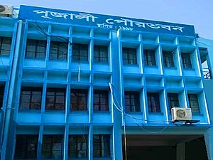
 Pujali Municipality | |
 Interactive map outlining Pujali | |
| Coordinates: 22°27′36″N 88°08′02″E / 22.4601371°N 88.1340191°E | |
| Country | |
| State | |
| Division | Presidency |
| District | South 24 Parganas |
| Government | |
| • Type | Municipality |
| • Body | Pujali Municipality |
| Area | |
• Total | 8.32 km2 (3.21 sq mi) |
| Elevation | 8 m (26 ft) |
| Population (2011) | |
• Total | 37,047 |
| • Density | 4,500/km2 (12,000/sq mi) |
| Demographics | |
| • Literacy | 78.80 per cent |
| • Sex ratio | 956 ♂/♀ |
| Languages | |
| • Official | Bengali[1][2] |
| • Additional official | English[1] |
| Time zone | UTC+5:30 (IST) |
| PIN | 700138 |
| Telephone code | +91 33 |
| Vehicle registration | WB-19, WB-20, WB-95, WB-96, WB-97, WB-98 |
| Lok Sabha constituency | Diamond Harbour |
| Vidhan Sabha constituency | Budge Budge |
| Website | pujalimunicipality |
Pujali (Bengali: [puːd͡ʒɑːlɪ] ⓘ) is a city and a municipality of the South 24 Parganas district in the Indian state of West Bengal. It is a part of the area covered by Kolkata Metropolitan Development Authority (KMDA).[3]
Geography
[edit]
3miles
Gangadharpur
M: municipal city/ town, CT: census town, R: rural/ urban centre,
Owing to space constraints in the small map, the actual locations in a larger map may vary slightly
Bakrahat is in Bishnupur II CD block, but Lakshmibala Rural Hospital at Bakrahat serves Budge Budge II CD block and so it is included here.
Area overview
[edit]Alipore Sadar subdivision is the most urbanized part of the South 24 Parganas district. 59.85% of the population lives in the urban areas and 40.15% lives in the rural areas. In the northern portion of the subdivision (shown in the map alongside) there are 21 census towns. The entire district is situated in the Ganges Delta and the subdivision, on the east bank of the Hooghly River, is an alluvial stretch, with industrial development[4][5][6]
Note: The map alongside presents some of the notable locations in the subdivision. All places marked in the map are linked in the larger full screen map.
Location
[edit]Pujali is located at 22°27′36″N 88°08′02″E / 22.4601371°N 88.1340191°E. It has an average elevation of 8 metres (26 ft).[7]
Balarampur, Uttar Raypur, Buita, Benjanhari Acharial, Abhirampur and Nischintapur form a cluster of census towns around Budge Budge and Pujali, as per the map of the Budge Budge I CD block on the page number 167 in the District Census Handbook 2011 for the South 24 Parganas district.[8]
Climate
[edit]Köppen-Geiger climate classification system classifies its climate as tropical wet and dry (Aw).
| Climate data for Pujali | |||||||||||||
|---|---|---|---|---|---|---|---|---|---|---|---|---|---|
| Month | Jan | Feb | Mar | Apr | May | Jun | Jul | Aug | Sep | Oct | Nov | Dec | Year |
| Mean daily maximum °C (°F) | 25.4 (77.7) |
27.7 (81.9) |
31.4 (88.5) |
33.1 (91.6) |
33.4 (92.1) |
32.3 (90.1) |
30.7 (87.3) |
30.8 (87.4) |
31.2 (88.2) |
30.8 (87.4) |
28.1 (82.6) |
25.1 (77.2) |
30.0 (86.0) |
| Daily mean °C (°F) | 19.9 (67.8) |
22.7 (72.9) |
27 (81) |
29.3 (84.7) |
30 (86) |
29.5 (85.1) |
28.5 (83.3) |
28.6 (83.5) |
28.5 (83.3) |
27.5 (81.5) |
23.5 (74.3) |
20 (68) |
26.3 (79.3) |
| Mean daily minimum °C (°F) | 14.5 (58.1) |
17.7 (63.9) |
22.6 (72.7) |
25.6 (78.1) |
26.7 (80.1) |
26.8 (80.2) |
26.4 (79.5) |
26.4 (79.5) |
25.9 (78.6) |
24.2 (75.6) |
19 (66) |
14.6 (58.3) |
22.5 (72.6) |
| Average precipitation mm (inches) | 14 (0.6) |
17 (0.7) |
20 (0.8) |
34 (1.3) |
96 (3.8) |
244 (9.6) |
323 (12.7) |
322 (12.7) |
321 (12.6) |
172 (6.8) |
30 (1.2) |
1 (0.0) |
1,594 (62.8) |
| Source: World Weather Online (altitude: 8 m)[9] | |||||||||||||
Demographics
[edit]Population
[edit]| Year | Pop. | ±% |
|---|---|---|
| 1991 | 10,112 | — |
| 2001 | 33,858 | +234.8% |
| 2011 | 37,047 | +9.4% |
| Source: Census of India[10] | ||
According to the 2011 Census of India, Pujali had a total population of 37,047, of which 18,940 (51%) were males and 18,107 (49%) were females. It had a population density of 4,453 inhabitants per square kilometre (11,530/sq mi) with a sex ratio of 956 females for every 1000 males. There were 4,316 persons in the age range of 0 to 6 years. The Scheduled Castes numbered 5,480 (14.79%) and the Scheduled Tribes numbered 937 (2.53%). The total number of literate persons was 25,791 (78.80% of the population over 6 years) out of which males numbered 13,827 (82.59% of the male population over 6 years) and females numbered 11,964 (74.82% of the female population over 6 years). Pujali had a total of 8,587 households as of 2011.[11]
Language
[edit]At the time of the 2011 Census of India, 98.18% of the population spoke Bengali, 1.79% Hindi and 0.02% Urdu as their first language.[12]
Religion
[edit]According to the 2011 Census of India, 58.54% of the population is Hindu, 41.20% Muslim, 0.16% Christian, 0.01% Sikh, 0.02% Buddhist and 0.01% Jain. 0.05% did not state a religion in the census.[13]
Civic administration
[edit]Municipality
[edit]Pujali Municipality covers an area of 8.32 km2 (3.21 sq mi). It has jurisdiction over the entire city of Pujali. The municipality was established in 1996. It is divided into 15 administrative wards. According to the 2022 municipal election, it is being controlled by the All India Trinamool Congress.[14][15]
Police station
[edit]Pujali police station has jurisdiction over parts of the Pujali Municipality, and the Budge Budge I CD block.[16][17]
CD block HQ
[edit]The headquarters of the Budge Budge I CD block are located at Purba Nischintapur.[18] The map of the CD block Budge Budge I on the page number 167 in the District Census Handbook 2011 for the South 24 Parganas district shows the headquarters of the CD block as being in Pujali.[19]
Transport
[edit]Pujali is on the Budge Budge Trunk Road.[20]
Budge Budge railway station is located nearby.[20]
Healthcare
[edit]There is a primary health centre, with 6 beds, at Biraj Lakshmi (PO Pujali).[21]
References
[edit]- ^ a b "Fact and Figures". Wb.gov.in. Retrieved 5 July 2019.
- ^ "52nd Report of the Commissioner for Linguistic Minorities in India" (PDF). Nclm.nic.in. Ministry of Minority Affairs. p. 85. Archived from the original (PDF) on 25 May 2017. Retrieved 5 July 2019.
- ^ "Base Map of Kolkata Metropolitan Area". Kolkata Metropolitan Development Authority. Archived from the original on 28 September 2007. Retrieved 3 September 2007.
- ^ "District Statistical Handbook 2014 South Twety-four Parganas". Table 2.1, 2.2, 2.4b. Department of Statistics and Programme Implementation, Government of West Bengal. Archived from the original on 21 January 2019. Retrieved 5 December 2019.
- ^ "Census of India 2011, West Bengal, District Census Handbook, South Twentyfour Parganas, Series – 20, Part XII-A, Village and Town Directory" (PDF). Page 13, Physiography. Directorate of Census Operations, West Bengal. Retrieved 5 December 2019.
- ^ "District Human Development Report: South 24 Parganas". Chapter 9: Sundarbans and the Remote Islanders, p 290-311. Development & Planning Department, Government of West Bengal, 2009. Archived from the original on 5 October 2016. Retrieved 5 December 2019.
- ^ Falling Rain Genomics, Inc - Pujali
- ^ "District Census Handbook South Twentyfour Parganas, Census of India 2011, Series 20, Part XII A" (PDF). Page 167 – Map of Budge Budge I CD block. Directorate of Census Operations, West Bengal. Retrieved 24 September 2019.
- ^ "Climate: Pujali". World Weather Online. Retrieved 14 January 2014.
- ^ "Census of India 2011, West Bengal, District Census Handbook, South Twentyfour Parganas, Series – 20, Part XII-A, Village and Town Directory" (PDF). Section II Town Directory, Pages 999-1031 Statement I: Growth History, Pages 999-1006. Directorate of Census Operations, West Bengal. Retrieved 17 October 2019.
- ^ "Census of India 2011, West Bengal, District Census Handbook, South Twentyfour Parganas, Series – 20, Part XII-B, Village and Town Wise Primary Census Abstract" (PDF). Urban PCA-Town wise Primary Census Abstract, Pages 536-583. Directorate of Census Operations, West Bengal. Retrieved 17 October 2019.
- ^ a b "Table C-16 Population by Mother Tongue: West Bengal". www.censusindia.gov.in. Registrar General and Census Commissioner of India.
- ^ a b "Table C-01 Population by Religion: West Bengal". censusindia.gov.in. Registrar General and Census Commissioner of India. 2011.
- ^ "Pujali Municipality". West Bengal Valuation Board. Government of West Bengal. Retrieved 18 May 2015.
- ^ "Pujali Municipality". Department of Municipal Affairs. Government of West Bengal. Archived from the original on 21 April 2017. Retrieved 18 May 2015.
- ^ "Pujali police station". Diamond Harbour police district. West Bengal police. Retrieved 20 October 2019.
- ^ "District Statistical Handbook 2014 South 24 Parganas". Table No. 2.1. Department of Statistics and Programme Implementation, Government of West Bengal. Retrieved 20 October 2019.
- ^ "BDO Offices under South 24 Parganas District". West Bengal Public Library Network, Government of West Bengal. Archived from the original on 3 October 2018. Retrieved 17 October 2019.
- ^ "Census of India 2011, West Bengal, District Census Handbook, South Twentyfour Parganas, Series – 20, Part XII-A, Village and Town Directory" (PDF). Page 167 - Map of Budge Budge I CD block. Directorate of Census Operations, West Bengal. Retrieved 17 October 2019.
- ^ a b Google maps
- ^ "Health & Family Welfare Department" (PDF). Health Statistics – Primary Health Centres. Government of West Bengal. Retrieved 3 November 2019.
External links
[edit] Media related to Pujali at Wikimedia Commons


