Microregion of Porangatu: Difference between revisions
Appearance
Content deleted Content added
m Giso6150 moved page Porangatu Microregion to Microregion of Porangatu: standardize per WikiProject Brazil |
Rescuing 0 sources and tagging 1 as dead. #IABot (v1.4beta) |
||
| Line 22: | Line 22: | ||
== Municipalities == |
== Municipalities == |
||
The microregion consists of the following municipalities:<ref>[http://servicodados.ibge.gov.br/Download/Download.ashx?u=geoftp.ibge.gov.br/organizacao_territorial/divisao_territorial/2014/dtb_2014_v2.zip Instituto Brasileiro de Geografia e Estatística], territorial division.</ref> |
The microregion consists of the following municipalities:<ref>[http://servicodados.ibge.gov.br/Download/Download.ashx?u=geoftp.ibge.gov.br/organizacao_territorial/divisao_territorial/2014/dtb_2014_v2.zip Instituto Brasileiro de Geografia e Estatística]{{dead link|date=June 2017 |bot=InternetArchiveBot |fix-attempted=yes }}, territorial division.</ref> |
||
*[[Alto Horizonte]] |
*[[Alto Horizonte]] |
||
*[[Amaralina]] |
*[[Amaralina]] |
||
Latest revision as of 18:31, 10 June 2017
Porangatu | |
|---|---|
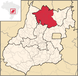
 Location in Goias state | |
| Country | Brazil |
| State | Goiás |
| Mesoregion | Norte Goiano |
| Municipalities | 19 |
| Area | |
• Total | 35,287 km2 (13,624 sq mi) |
| Population (2007) | |
• Total | 220,794 |
| • Density | 6.3/km2 (16/sq mi) |
The Porangatu Microregion is a statistical region created by IBGE (Instituto Brasileiro de Geografia e Economia) in north-central Goiás state, Brazil. The most important city is Porangatu.
Municipalities
[edit]The microregion consists of the following municipalities:[1]
- Alto Horizonte
- Amaralina
- Bonópolis
- Campinaçu
- Campinorte
- Campos Verdes
- Estrela do Norte
- Formoso
- Mara Rosa
- Minaçu
- Montividiu do Norte
- Mutunópolis
- Niquelândia
- Nova Iguaçu de Goiás
- Porangatu
- Santa Tereza de Goiás
- Santa Terezinha de Goiás
- Trombas
- Uruaçu
See also
[edit]References
[edit]- ^ Instituto Brasileiro de Geografia e Estatística[permanent dead link], territorial division.
13°26′27″S 49°08′56″W / 13.44083°S 49.14889°W
