Microregion of Porangatu: Difference between revisions
Appearance
Content deleted Content added
m robot Adding: nl:Porangatu (microregio) |
Rescuing 0 sources and tagging 1 as dead. #IABot (v1.4beta) |
||
| (23 intermediate revisions by 13 users not shown) | |||
| Line 1: | Line 1: | ||
{{Infobox settlement |
|||
| ⚫ | |||
| name = Porangatu |
|||
| type = [[Microregion (Brazil)|Microregion]] |
|||
| image_map = Goias Micro Porangatu.svg |
|||
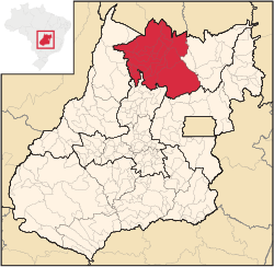
| map_caption = Location in Goias state |
|||
| subdivision_type = Country |
|||
| subdivision_name = [[Brazil]] |
|||
| subdivision_type1 = [[States of Brazil|State]] |
|||
| subdivision_name1 = [[Goiás]] |
|||
| subdivision_type2 = [[Mesoregions of Brazil|Mesoregion]] |
|||
| subdivision_name2 = [[Norte Goiano]] |
|||
| area_total_km2 = 35,287 |
|||
| population_as_of = 2007 |
|||
| population_total = 220,794 |
|||
| population_density_km2 = auto |
|||
| parts_type = Municipalities |
|||
| parts_style = para |
|||
| p1 = 19 |
|||
| website = |
|||
}} |
|||
| ⚫ | |||
== Municipalities == |
|||
===Important Data (2000)=== |
|||
The microregion consists of the following municipalities:<ref>[http://servicodados.ibge.gov.br/Download/Download.ashx?u=geoftp.ibge.gov.br/organizacao_territorial/divisao_territorial/2014/dtb_2014_v2.zip Instituto Brasileiro de Geografia e Estatística]{{dead link|date=June 2017 |bot=InternetArchiveBot |fix-attempted=yes }}, territorial division.</ref> |
|||
*População: 226,766 |
|||
*Cities: 19 |
|||
*Total Area: 35,287.40 km² |
|||
*Population Density: 6.43 hab/km² |
|||
In area this microregion is smaller than [[Taiwan]] and larger than [[Moldova]]. |
|||
=== Cities in the Porangatu Microregion === |
|||
*[[Alto Horizonte]] |
*[[Alto Horizonte]] |
||
*[[Amaralina]] |
*[[Amaralina]] |
||
| Line 22: | Line 35: | ||
*[[Montividiu do Norte]] |
*[[Montividiu do Norte]] |
||
*[[Mutunópolis]] |
*[[Mutunópolis]] |
||
*[[Niquelândia]] |
*[[Niquelândia]] |
||
*[[Nova Iguaçu de Goiás]] |
*[[Nova Iguaçu de Goiás]] |
||
*[[Porangatu]] |
*[[Porangatu]] |
||
*[[Santa Tereza de Goiás]] |
*[[Santa Tereza de Goiás]] |
||
*[[Santa Terezinha de Goiás]] |
*[[Santa Terezinha de Goiás]] |
||
*[[Trombas]] |
*[[Trombas]] |
||
*[[Uruaçu]] |
*[[Uruaçu]] |
||
==See also== |
|||
*[[List of municipalities in Goiás]] |
|||
*[[Microregions of Goiás]] |
|||
==References== |
|||
{{Reflist}} |
|||
{{coord|13|26|27|S|49|08|56|W|type:adm3rd_source:itwiki|display=title}} |
|||
| ⚫ | |||
| ⚫ | |||
{{Goiás-geo-stub}} |
|||
[[nl:Porangatu (microregio)]] |
|||
[[pt:Microrregião de Porangatu]] |
|||
Latest revision as of 18:31, 10 June 2017
Porangatu | |
|---|---|
 Location in Goias state | |
| Country | Brazil |
| State | Goiás |
| Mesoregion | Norte Goiano |
| Municipalities | 19 |
| Area | |
• Total | 35,287 km2 (13,624 sq mi) |
| Population (2007) | |
• Total | 220,794 |
| • Density | 6.3/km2 (16/sq mi) |
The Porangatu Microregion is a statistical region created by IBGE (Instituto Brasileiro de Geografia e Economia) in north-central Goiás state, Brazil. The most important city is Porangatu.
Municipalities
[edit]The microregion consists of the following municipalities:[1]
- Alto Horizonte
- Amaralina
- Bonópolis
- Campinaçu
- Campinorte
- Campos Verdes
- Estrela do Norte
- Formoso
- Mara Rosa
- Minaçu
- Montividiu do Norte
- Mutunópolis
- Niquelândia
- Nova Iguaçu de Goiás
- Porangatu
- Santa Tereza de Goiás
- Santa Terezinha de Goiás
- Trombas
- Uruaçu
See also
[edit]References
[edit]- ^ Instituto Brasileiro de Geografia e Estatística[permanent dead link], territorial division.
13°26′27″S 49°08′56″W / 13.44083°S 49.14889°W
