Saline River (Michigan): Difference between revisions
Appearance
Content deleted Content added
Added coordinates |
m →References: add authority control |
||
| (14 intermediate revisions by 7 users not shown) | |||
| Line 1: | Line 1: | ||
{{Infobox river |
|||
{{Infobox_River |
|||
| |
| name = Saline River |
||
| image = Max Adler Trail July 2018 1 (Saline River).jpg |
|||
| ⚫ | |||
| image_size = |
| image_size = 275 |
||
| |
| image_caption = Saline River in [[Saline, Michigan]] |
||
| pushpin_map = USA Michigan |
|||
| ⚫ | |||
| pushpin_map_size = 250 |
|||
| ⚫ | |||
| pushpin_map_caption= Location within the state of Michigan |
|||
| mouth = [[River Raisin]], [[Michigan]]<br /> |
|||
| ⚫ | |||
| ⚫ | |||
| source1_coordinates= {{coord|42.1575|-83.9396|region:US-MI}} |
|||
| ⚫ | |||
| ⚫ | |||
| length_mi = 45.6 |
|||
| |
| mouth_location = [[River Raisin]], [[Michigan]] |
||
| ⚫ | |||
| ⚫ | |||
| |
| subdivision_type1 = Country |
||
| ⚫ | |||
| ⚫ | |||
| length = {{convert|45.6|mi|km|abbr=on}} |
|||
| source1_elevation = |
|||
| ⚫ | |||
| ⚫ | |||
| ⚫ | |||
}} |
}} |
||
[[ |
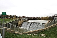
[[File:Saline River Dam.JPG|thumb|200px|right|Saline River Dam, Saline]] |
||
The '''Saline River''' is a {{convert|45.6|mi|km|adj=mid|-long}}<ref name=NHD>U.S. Geological Survey. National Hydrography Dataset high-resolution flowline data. [http://viewer.nationalmap.gov/viewer/ The National Map], accessed May 19, 2011</ref> river in southeastern [[Michigan]] in the [[United States]]. A tributary of the [[River Raisin]], it originates in [[Washtenaw County, Michigan|Washtenaw County]]; flows through the cities of [[Saline, Michigan|Saline]] and [[Milan, Michigan|Milan]], where it enters [[Monroe County, Michigan|Monroe County]]; then joins the River Raisin at the village of [[Dundee, Michigan|Dundee]]. Although named after the city of Saline, which was once famous for its salt springs, the Saline River is not at all salty. |
The '''Saline River''' is a {{convert|45.6|mi|km|adj=mid|-long}}<ref name=NHD>U.S. Geological Survey. National Hydrography Dataset high-resolution flowline data. [http://viewer.nationalmap.gov/viewer/ The National Map], accessed May 19, 2011</ref> river in southeastern [[Michigan]] in the [[United States]]. A tributary of the [[River Raisin]], it originates in [[Washtenaw County, Michigan|Washtenaw County]]; flows through the cities of [[Saline, Michigan|Saline]] and [[Milan, Michigan|Milan]], where it enters [[Monroe County, Michigan|Monroe County]]; then joins the River Raisin at the village of [[Dundee, Michigan|Dundee]]. Although named after the city of Saline, which was once famous for its salt springs, the Saline River is not at all salty. |
||
| Line 25: | Line 30: | ||
*[http://waterdata.usgs.gov/mi/nwis/current/?type=flow Michigan Streamflow Data from the USGS] |
*[http://waterdata.usgs.gov/mi/nwis/current/?type=flow Michigan Streamflow Data from the USGS] |
||
{{commons category}} |
|||
{{authority control}} |
|||
[[Category:Rivers of Michigan]] |
[[Category:Rivers of Michigan]] |
||
[[Category:Rivers of Washtenaw County, Michigan]] |
|||
[[Category:Rivers of Monroe County, Michigan]] |
|||
[[Category:Tributaries of Lake Erie]] |
|||
{{ |
{{WashtenawCountyMI-geo-stub}} |
||
{{MonroeCountyMI-geo-stub}} |
|||
{{Michigan-river-stub}} |
|||
Latest revision as of 02:41, 11 May 2020
| Saline River | |
|---|---|
 Saline River in Saline, Michigan | |
| Location | |
| Country | United States |
| Physical characteristics | |
| Source | |
| • location | Washtenaw County |
| • coordinates | 42°09′27″N 83°56′23″W / 42.1575°N 83.9396°W[1] |
| Mouth | |
• location | River Raisin, Michigan |
• coordinates | 41°58′31″N 83°36′46″W / 41.9753°N 83.6127°W |
| Length | 45.6 mi (73.4 km) |

The Saline River is a 45.6-mile-long (73.4 km)[2] river in southeastern Michigan in the United States. A tributary of the River Raisin, it originates in Washtenaw County; flows through the cities of Saline and Milan, where it enters Monroe County; then joins the River Raisin at the village of Dundee. Although named after the city of Saline, which was once famous for its salt springs, the Saline River is not at all salty.
See also
[edit]References
[edit]- ^ "Saline River". Geographic Names Information System. United States Geological Survey, United States Department of the Interior.
- ^ U.S. Geological Survey. National Hydrography Dataset high-resolution flowline data. The National Map, accessed May 19, 2011
Wikimedia Commons has media related to Saline River (Michigan).

