Natchamba: Difference between revisions
Appearance
Content deleted Content added
m Robot - Speedily moving category Bassar Prefecture to Category:Bassar (prefecture) per CFDS. |
m Task 18 (cosmetic): eval 2 templates: del empty params (1×); hyphenate params (2×); |
||
| (11 intermediate revisions by 8 users not shown) | |||
| Line 6: | Line 6: | ||
|native_name = <!-- for cities whose native name is not in English --> |
|native_name = <!-- for cities whose native name is not in English --> |
||
|nickname = |
|nickname = |
||
|settlement_type = |
|settlement_type = Village |
||
|motto = |
|motto = |
||
<!-- images and maps -----------> |
<!-- images and maps -----------> |
||
| Line 35: | Line 35: | ||
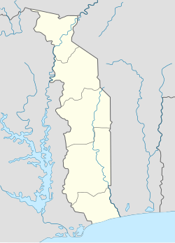
|pushpin_map_caption =Location in Togo |
|pushpin_map_caption =Location in Togo |
||
<!-- Location ------------------> |
<!-- Location ------------------> |
||
|coordinates_display = inline,title |
|||
|coordinates_region = TG |
|||
|subdivision_type = Country |
|subdivision_type = Country |
||
|subdivision_name = [[Image:Flag of Togo.svg|25px]] [[Togo]] |
|subdivision_name = [[Image:Flag of Togo.svg|25px]] [[Togo]] |
||
| Line 42: | Line 40: | ||
|subdivision_name1 = [[Kara Region]] |
|subdivision_name1 = [[Kara Region]] |
||
|subdivision_type2 = [[Prefectures of Togo|Prefecture]] |
|subdivision_type2 = [[Prefectures of Togo|Prefecture]] |
||
|subdivision_name2 = [[Bassar]] |
|subdivision_name2 = [[Bassar Prefecture]] |
||
|subdivision_type3 = |
|subdivision_type3 = |
||
|subdivision_name3 = |
|subdivision_name3 = |
||
| Line 108: | Line 106: | ||
|timezone_DST = |
|timezone_DST = |
||
|utc_offset_DST = |
|utc_offset_DST = |
||
|coordinates = {{coord|9|24|N|0|35|E|region:TG|display=inline,title}} |
|||
|latd=9 |latm=24|lats= |latNS=N |
|||
|elevation_footnotes = <ref name="geoview">{{cite web|url=http://tg.geoview.info/natchamba,2364873 |title=Natchamba (populated place) |publisher=Tg.geoview.info |access-date=2015-03-19}}</ref> |
|||
|longd=0|longm=35|longs= |longEW=E |
|||
| ⚫ | |||
|elevation_footnotes = <!--for references: use <ref> </ref> tags--> |
|||
| ⚫ | |||
|elevation_ft = |
|elevation_ft = |
||
<!-- Area/postal codes & others --------> |
<!-- Area/postal codes & others --------> |
||
| Line 124: | Line 121: | ||
|footnotes = |
|footnotes = |
||
}} |
}} |
||
'''Natchamba''' is a |
'''Natchamba''' is a village in the [[Bassar Prefecture]] in the [[Kara Region]] of north-western [[Togo]].<ref name="geoview"/><ref>{{cite book|title=Journal des africanistes|url=https://books.google.com/books?id=L58rAAAAIAAJ|access-date=19 March 2015|edition=2|volume=56|year=1986|publisher=Société des africanistes|page=51}}</ref> |
||
==References== |
==References== |
||
{{reflist}} |
|||
<references /> |
|||
==External links== |
|||
*[http://www.maplandia.com/togo/kara/bassar/natchamba/ Satellite map at Maplandia.com] |
|||
*[http://encarta.msn.com/encnet/features/mapcenter/map.aspx Search for Natchamba in the MSN Encarta atlas] |
|||
{{Bassar Prefecture}} |
{{Bassar Prefecture}} |
||
[[Category:Populated places in Kara Region]] |
[[Category:Populated places in Kara Region]] |
||
[[Category:Bassar |
[[Category:Bassar Prefecture]] |
||
Latest revision as of 12:59, 8 December 2020
Natchamba | |
|---|---|
Village | |
| Coordinates: 9°24′N 0°35′E / 9.400°N 0.583°E | |
| Country | |
| Region | Kara Region |
| Prefecture | Bassar Prefecture |
| Elevation | 636 ft (194 m) |
| Time zone | UTC + 0 |
Natchamba is a village in the Bassar Prefecture in the Kara Region of north-western Togo.[1][2]
References
[edit]- ^ a b "Natchamba (populated place)". Tg.geoview.info. Retrieved 2015-03-19.
- ^ Journal des africanistes. Vol. 56 (2 ed.). Société des africanistes. 1986. p. 51. Retrieved 19 March 2015.

