Casco Viejo: Difference between revisions
mNo edit summary |
No edit summary |
||
| (One intermediate revision by one other user not shown) | |||
| Line 1: | Line 1: | ||
{{for|the historic district in Panama|Casco Viejo, Panama}} |
{{for|the historic district in Panama|Casco Viejo, Panama}} |
||
{{Infobox settlement |
|||
| ⚫ | |||
| name = Casco Viejo / Siete Calles |
|||
| ⚫ | |||
| native_name = Alde Zaharra / Zazpikaleak |
|||
| native_name_lang = eu |
|||
| image_skyline = Vue de la ville ancienne (Casco Viejo) de Bilbao (3452403823).jpg |
|||
| settlement_type = Neighbourhood |
|||
| subdivision_type = Country |
|||
| subdivision_name = [[Spain]] |
|||
| subdivision_type1 = [[Autonomous communities of Spain|Autonomous community]] |
|||
| subdivision_name1 = [[Basque Country (autonomous community)|Basque Country]] |
|||
| subdivision_type2 = [[Provinces of Spain|Province]] |
|||
| subdivision_name2 = [[Biscay]] |
|||
| subdivision_type3 = [[Municipalities of Spain|Municipality]] |
|||
| subdivision_name3 = [[Bilbao]] |
|||
| subdivision_type4 = District |
|||
| subdivision_name4 = [[Ibaiondo]] |
|||
| module = |
|||
{{designation list |
|||
| embed=yes |
|||
| designation1 = Spain |
|||
| designation1_type = Non-movable |
|||
| designation1_criteria = Historic ensemble |
|||
| designation1_date = 9 November 1972 |
|||
| designation1_number = RI-53-0000144 |
|||
}} |
|||
}} |
|||
'''{{lang|es|Las Siete Calles}}''' or '''{{lang|es|Casco Viejo}}''' in [[Spanish language|Spanish]] or '''{{lang|eu|Zazpikaleak}}''' or '''{{lang|eu|Alde Zaharra}}''' in [[Basque language|Basque]] are different names for the medieval neighbourhood of [[Bilbao]], part of the [[Ibaiondo]] district. The |
'''{{lang|es|Las Siete Calles}}''' or '''{{lang|es|Casco Viejo}}''' in [[Spanish language|Spanish]] or '''{{lang|eu|Zazpikaleak}}''' or '''{{lang|eu|Alde Zaharra}}''' in [[Basque language|Basque]] are different names for the medieval neighbourhood of [[Bilbao]], part of the [[Ibaiondo]] district. The walled section of the town existed until the end of the 19th century and was known by the names Seven Streets or Old Town, respectively. |
||
==The Seven Streets== |
==The Seven Streets== |
||
| Line 20: | Line 44: | ||
<gallery> |
<gallery> |
||
| ⚫ | |||
| ⚫ | |||
Image:Plaza nueva de Bilbao.JPG|[[Plaza Nueva, Bilbao|Plaza Nueva]] |
|||
File:Plaza nueva de Bilbao.JPG|[[Plaza Nueva, Bilbao|Plaza Nueva]] |
|||
File:Portal de Zamudio.JPG|Casco viejo, Portal de Zamudio |
|||
Image:Bilbao - Mercado de la Ribera 4.jpg|The market Mercado de la Ribera |
|||
File:Bilbao - Mercado de la Ribera 4.jpg|The market Mercado de la Ribera |
|||
File:La Ribera.JPG|La Ribera |
|||
</gallery> |
</gallery> |
||
Latest revision as of 21:34, 25 March 2023
Casco Viejo / Siete Calles
Alde Zaharra / Zazpikaleak | |
|---|---|
Neighbourhood | |
 | |
 | |
| Country | Spain |
| Autonomous community | Basque Country |
| Province | Biscay |
| Municipality | Bilbao |
| District | Ibaiondo |
| Type | Non-movable |
| Criteria | Historic ensemble |
| Designated | 9 November 1972 |
| Reference no. | RI-53-0000144 |
Las Siete Calles or Casco Viejo in Spanish or Zazpikaleak or Alde Zaharra in Basque are different names for the medieval neighbourhood of Bilbao, part of the Ibaiondo district. The walled section of the town existed until the end of the 19th century and was known by the names Seven Streets or Old Town, respectively.
The Seven Streets
[edit]The name Zazpikaleak or Las Siete Calles (The Seven Streets) come from the oldest part of the neighbourhood which included exactly 7 streets and some much more narrow alleys connecting them, called cantons (kantoi, cantón). The historical seven streets of Bilbao are:
- Somera, "upper"
- Artekale, "middle street"
- Tendería, "shopkeeper's"
- Belostikale, "rapid street"
- Carnicería Vieja, "old butchery"
- Barrenkale, "lower street"
- Barrenkale Barrena, "lower lower street"
The "8th" street is Ronda, which used to be the patrol street outside the walls. Later the town expanded northwards with the construction of the Plaza Berria or Plaza Nueva (new square) and the streets Santa María ("Saint Mary"), Bidebarrieta ("new ways"), Correo ("mail") and Askao. Nowadays the neighbourhood also includes the Ribera ("riverbank") street, the Arenal ("sandy place") Park and Esperanza ("hope") street as well.
The area is served by Casco Viejo station of the Bilbao Metro.
-
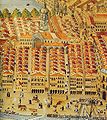
The seven parallel streets are visible in this picture from the 18th century.
-
The medieval town, now Casco Viejo, as seen in 1575.
-
Casco viejo, Portal de Zamudio
-
The market Mercado de la Ribera
-
La Ribera
Tourism
[edit]The area is probably the most colorful part of Bilbao, including many shops and taverns, several historical churches (San Antón, Santos Juanes, the Cathedral, San Nicolás), a large food retail market ( Mercado de la Ribera ), the public Arriaga Theatre, the seat of the Academy of the Basque Language (Euskaltzaindia), a ball court, and a public library. It is connected to the rest of the city and conurbation by the subway, tramway and buses. Three public elevators also connect Casco Viejo to the neighbourhoods of Begoña and Solokoetxe, which otherwise demand a rather intense uphill walk.
There is a tradition of middle-age men doing a tavern crawl drinking short glasses (chiquitos) of wine and singing choral songs.


