Kahal: Difference between revisions
Appearance
Content deleted Content added
reduce excessive coords precision |
|||
| (One intermediate revision by one other user not shown) | |||
| Line 2: | Line 2: | ||
{{Infobox Israel village |
{{Infobox Israel village |
||
| name = Kahal |
| name = Kahal |
||
| image = File: |
| image = File:KahalApr2023_04.jpg |
||
| caption = |
| caption = |
||
| imgsize = |
| imgsize = |
||
| Line 18: | Line 18: | ||
}} |
}} |
||
'''Kahal''' ({{ |
'''Kahal''' ({{langx|he|כָּחָל}}) is a [[moshav]] in the [[Galilee]] near [[Highway 85 (Israel)|Highway 85]] in northern [[Israel]]. Located on the border of the [[Upper Galilee]] and [[Lower Galilee]], north of Lake [[Sea of Galilee|Kinneret]] and just northwest of [[Tabgha]], it falls under the jurisdiction of [[Mevo'ot HaHermon Regional Council]]. In {{Israel populations|Year}} it had a population of {{Israel populations|Kahal}}.{{Israel populations|reference}} |
||
==References== |
==References== |
||
Latest revision as of 01:29, 1 November 2024
Kahal | |
|---|---|
 | |
| Coordinates: 32°53′30″N 35°30′35″E / 32.89167°N 35.50972°E | |
| Country | Israel |
| District | Northern |
| Council | Mevo'ot HaHermon |
| Affiliation | Moshavim Movement |
| Founded | 1980 |
| Population (2022)[1] | 475 |
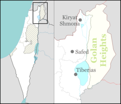
Kahal (Hebrew: כָּחָל) is a moshav in the Galilee near Highway 85 in northern Israel. Located on the border of the Upper Galilee and Lower Galilee, north of Lake Kinneret and just northwest of Tabgha, it falls under the jurisdiction of Mevo'ot HaHermon Regional Council. In 2022 it had a population of 475.[1]
References
[edit]- ^ a b "Regional Statistics". Israel Central Bureau of Statistics. Retrieved 21 March 2024.

