Williamstown, Missouri: Difference between revisions
Appearance
Content deleted Content added
added infobox |
add "use mdy dates" template |
||
| (6 intermediate revisions by 4 users not shown) | |||
| Line 1: | Line 1: | ||
{{Use mdy dates|date=July 2023}} |
|||
{{Infobox settlement |
{{Infobox settlement |
||
|official_name = Williamstown, Missouri |
|official_name = Williamstown, Missouri |
||
| Line 38: | Line 39: | ||
<!-- Area --> |
<!-- Area --> |
||
|unit_pref = Imperial |
|unit_pref = Imperial |
||
|area_footnotes = <ref name="TigerWebMapServer">{{cite web|title=ArcGIS REST Services Directory|url=https://tigerweb.geo.census.gov/arcgis/rest/services/TIGERweb/Places_CouSub_ConCity_SubMCD/MapServer|publisher=United States Census Bureau|accessdate=September 5, 2022}}</ref> |
|||
|area_footnotes = |
|||
|area_magnitude = |
|area_magnitude = |
||
|area_total_km2 = |
|area_total_km2 = 0.70 |
||
|area_land_km2 = |
|area_land_km2 = 0.70 |
||
|area_water_km2 = |
|area_water_km2 = 0.00 |
||
|area_total_sq_mi = |
|area_total_sq_mi = 0.27 |
||
|area_land_sq_mi = |
|area_land_sq_mi = 0.27 |
||
|area_water_sq_mi = |
|area_water_sq_mi = 0.00 |
||
<!-- Population --> |
<!-- Population --> |
||
|population_as_of = |
|population_as_of = [[2020 United States Census|2020]] |
||
|population_est = |
|population_est = |
||
|pop_est_as_of = |
|pop_est_as_of = |
||
|population_footnotes = |
|population_footnotes = |
||
|population_total = |
|population_total = 60 |
||
|population_density_km2 = |
|population_density_km2 = 85.38 |
||
|population_density_sq_mi = |
|population_density_sq_mi = 221.40 |
||
<!-- General information --> |
<!-- General information --> |
||
| Line 61: | Line 62: | ||
|timezone_DST = |
|timezone_DST = |
||
|utc_offset_DST = |
|utc_offset_DST = |
||
|elevation_footnotes = |
|elevation_footnotes = <ref name=gnis/> |
||
| |
|elevation_ft = 725 |
||
| ⚫ | |||
|elevation_ft = |
|||
|coordinates = |
|||
|postal_code_type = |
|postal_code_type = |
||
|postal_code = |
|postal_code = |
||
| Line 71: | Line 72: | ||
|blank_info = 29-80008 |
|blank_info = 29-80008 |
||
|blank1_name = [[Geographic Names Information System|GNIS]] feature ID |
|blank1_name = [[Geographic Names Information System|GNIS]] feature ID |
||
|blank1_info = |
|blank1_info = 2806411<ref name=gnis>{{GNIS|2806411}}</ref> |
||
|website = |
|website = |
||
|footnotes = |
|footnotes = |
||
| Line 80: | Line 81: | ||
==History== |
==History== |
||
Williamstown was laid out in 1856.<ref>{{cite news | url=https://news.google.com/newspapers?id=RN4kAAAAIBAJ&sjid=rRAGAAAAIBAJ&pg=823%2C432150 | title=Williamstown, now 150 years old, was once a busier town | work=Press-News Journal | date=Sep 28, 2006 | accessdate=1 November 2015 | author=Steinbeck, Dan | pages=4}}</ref> The community was named for its founder, Minus Williams.<ref>{{cite book | url=https://archive.org/details/bub_gb_RfAuAAAAYAAJ | title=How Missouri Counties, Towns and Streams Were Named | publisher=The State Historical Society of Missouri | author=Eaton, David Wolfe | year=1916 | pages=[https://archive.org/details/bub_gb_RfAuAAAAYAAJ/page/n82 185]}}</ref><ref>{{cite web | url=http://shsmo.org/manuscripts/ramsay/ramsay_lewis.html | archive-url=https://web.archive.org/web/20160624070552/http://shsmo.org/manuscripts/ramsay/ramsay_lewis.html | url-status=dead | archive-date=24 June 2016 | title=Lewis County Place Names, 1928–1945 (archived)| publisher=The State Historical Society of Missouri| accessdate=26 October 2016}}</ref> |
Williamstown was laid out in 1856.<ref>{{cite news | url=https://news.google.com/newspapers?id=RN4kAAAAIBAJ&sjid=rRAGAAAAIBAJ&pg=823%2C432150 | title=Williamstown, now 150 years old, was once a busier town | work=Press-News Journal | date=Sep 28, 2006 | accessdate=1 November 2015 | author=Steinbeck, Dan | pages=4}}</ref> The community was named for its founder, Minus Williams.<ref>{{cite book | url=https://archive.org/details/bub_gb_RfAuAAAAYAAJ | title=How Missouri Counties, Towns and Streams Were Named | publisher=The State Historical Society of Missouri | author=Eaton, David Wolfe | year=1916 | pages=[https://archive.org/details/bub_gb_RfAuAAAAYAAJ/page/n82 185]}}</ref><ref>{{cite web | url=http://shsmo.org/manuscripts/ramsay/ramsay_lewis.html | archive-url=https://web.archive.org/web/20160624070552/http://shsmo.org/manuscripts/ramsay/ramsay_lewis.html | url-status=dead | archive-date=24 June 2016 | title=Lewis County Place Names, 1928–1945 (archived)| publisher=The State Historical Society of Missouri| accessdate=26 October 2016}}</ref> |
||
==Demographics== |
|||
{{US Census population |
|||
|align=left|2020= 60 |
|||
|footnote=U.S. Decennial Census<ref name="DecennialCensus">{{cite web|url=http://www.census.gov/prod/www/decennial.html|title=Census of Population and Housing|publisher=Census.gov|accessdate=June 4, 2016}}</ref> |
|||
}}{{clear left}} |
|||
==Notable people== |
|||
*[[Elbert K. Fretwell]] educator |
|||
==References== |
==References== |
||
| Line 85: | Line 95: | ||
{{Lewis County, Missouri}} |
{{Lewis County, Missouri}} |
||
| ⚫ | |||
{{authority control}} |
{{authority control}} |
||
Latest revision as of 05:47, 30 July 2023
Williamstown, Missouri | |
|---|---|
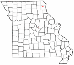
 Location of Williamstown in Missouri | |
| Coordinates: 40°14′27″N 91°47′51″W / 40.24083°N 91.79750°W | |
| Country | United States |
| State | Missouri |
| County | Lewis |
| Area | |
• Total | 0.27 sq mi (0.70 km2) |
| • Land | 0.27 sq mi (0.70 km2) |
| • Water | 0.00 sq mi (0.00 km2) |
| Elevation | 725 ft (221 m) |
| Population (2020) | |
• Total | 60 |
| • Density | 221.40/sq mi (85.38/km2) |
| FIPS code | 29-80008 |
| GNIS feature ID | 2806411[2] |
Williamstown is an unincorporated community in northern Lewis County, Missouri, United States.[3] It is located at the intersection of Missouri Supplemental Routes A and E, approximately twenty miles northwest of Canton. The community is part of the Quincy, IL–MO Micropolitan Statistical Area.
History
[edit]Williamstown was laid out in 1856.[4] The community was named for its founder, Minus Williams.[5][6]
Demographics
[edit]| Census | Pop. | Note | %± |
|---|---|---|---|
| 2020 | 60 | — | |
| U.S. Decennial Census[7] | |||
Notable people
[edit]- Elbert K. Fretwell educator
References
[edit]- ^ "ArcGIS REST Services Directory". United States Census Bureau. Retrieved September 5, 2022.
- ^ a b U.S. Geological Survey Geographic Names Information System: Williamstown, Missouri
- ^ U.S. Geological Survey Geographic Names Information System: Williamstown, Missouri
- ^ Steinbeck, Dan (September 28, 2006). "Williamstown, now 150 years old, was once a busier town". Press-News Journal. p. 4. Retrieved November 1, 2015.
- ^ Eaton, David Wolfe (1916). How Missouri Counties, Towns and Streams Were Named. The State Historical Society of Missouri. pp. 185.
- ^ "Lewis County Place Names, 1928–1945 (archived)". The State Historical Society of Missouri. Archived from the original on June 24, 2016. Retrieved October 26, 2016.
- ^ "Census of Population and Housing". Census.gov. Retrieved June 4, 2016.

