Iwajowa: Difference between revisions
Add heading |
remove apparently incorrect {{coord}} to match the spec and avoid errors, switch to new mapframe syntax |
||
| (6 intermediate revisions by 5 users not shown) | |||
| Line 50: | Line 50: | ||
|utc_offset_DST = |
|utc_offset_DST = |
||
|coordinates = |
|coordinates = |
||
| mapframe = yes |
|||
|module={{Infobox mapframe|wikidata=yes|zoom=8|marker=village|coord={{WikidataCoord|display=i}}}} |
|||
| mapframe-zoom = 8 |
|||
| mapframe-marker = village |
|||
|elevation_footnotes = |
|elevation_footnotes = |
||
|elevation_m = |
|elevation_m = |
||
| Line 62: | Line 64: | ||
|footnotes = |
|footnotes = |
||
}} |
}} |
||
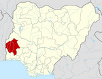
'''Iwajowa''' is a [[Local Government Areas of Nigeria|Local Government Area]] in [[Oyo State]], [[Nigeria]]. Its headquarter is in the town of Iwere Ile. Iwere-ile had been a powerful war town in the old Oyo empire, dreadful for many Oyo indigenes,{{Clarify|POV|date=March 2019}} as well as the Alaafin to attack. Iwere-ile became the headquarters of Iwajowa |
'''Iwajowa''' is a [[Local Government Areas of Nigeria|Local Government Area]] in [[Oyo State]], [[Nigeria]]. Its headquarter is in the town of Iwere Ile. Iwere-ile had been a powerful war town in the old Oyo empire, dreadful for many Oyo indigenes,{{Clarify|POV|date=March 2019}} as well as the Alaafin to attack. Iwere-ile became the headquarters of Iwajowa Local Government Area on 4 December 1996 upon the creation of the new local government under the Gen Sanni Abacha's regime. Other town and settlements include Iganna, Ilaji-Ile, Idiko-Ile, Ayetoro Ile, Itasa, Idiko Ago, Elekookan, Ijio, Ayegun Wasimi and over 350 villages and farm settlements. The inhabitants of the area are predominantly Yoruba cohabiting peacefully with other tribes such as Fulani, Hausa, Tiv, Egede and others who engage in cattle rearing, large scale farming and hunting. This explains why food and cash crops are readily available at considerably cheap rates.<ref>{{Cite web |title=Iwajowa Local Government Area |url=https://www.manpower.com.ng/places/lga/686/iwajowa |access-date=2024-02-17 |website=www.manpower.com.ng}}</ref> |
||
Equally, the council is endowed with rich culture glazed with annual traditional festivals such as; Oro, Ogun, Sango and Egungun festivals and also Gelede cultural display. Iwajowa Local Government is bounded in the North by Itesiwaju Local Government, in the south by Ibarapa North Local Government, in the East by Kajola Local Government and in the West by Republic of Bennin.It has an area of 2,529 |
Equally, the council is endowed with rich culture glazed with annual traditional festivals such as; Oro, Ogun, Sango and Egungun festivals and also Gelede cultural display. Iwajowa Local Government is bounded in the North by Itesiwaju Local Government, in the south by Ibarapa North Local Government, in the East by Kajola Local Government and in the West by Republic of Bennin.It has an area of 2,529 km{{sup|2}} and a population of 102,980 at the 2006 census. |
||
The [[postal code]] of the area is 202.<ref>{{cite web|title=Post Offices- with map of LGA |publisher=NIPOST |url=http://www.nipost.gov.ng/PostCode.aspx |accessdate=2009-10-20 |url-status=dead |archiveurl=https://web.archive.org/web/20091007011423/http://www.nipost.gov.ng/PostCode.aspx |archivedate=2009-10-07 }}</ref> |
The [[postal code]] of the area is 202.<ref>{{cite web|title=Post Offices- with map of LGA |publisher=NIPOST |url=http://www.nipost.gov.ng/PostCode.aspx |accessdate=2009-10-20 |url-status=dead |archiveurl=https://web.archive.org/web/20091007011423/http://www.nipost.gov.ng/PostCode.aspx |archivedate=2009-10-07 }}</ref> |
||
== Climate == |
== Climate == |
||
During the wet season, which is humid year-round, mainly muggy, and partially cloudy, the temperature rarely falls below 65°F or rises above 99°F.<ref name="db-city">{{Cite web |title=Iwajowa, Oyo, Nigeria - City, Town and Village of the world |url=https://en.db-city.com/Nigeria--Oyo--Iwajowa |access-date=2023-09-15 |website=en.db-city.com |language=en}}</ref><ref>{{Cite web |title=Iwere-Ile Climate, Weather By Month, Average Temperature (Nigeria) - Weather Spark |url=https://weatherspark.com/y/48850/Average-Weather-in-Iwere-Ile-Nigeria-Year-Round |access-date=2023-09-15 |website=Weather Spark |language=en}}</ref> |
|||
==References== |
==References== |
||
{{Reflist}} |
{{Reflist}} |
||
{{coord missing|Nigeria}} |
|||
{{LGAs and communities of Oyo State}} |
{{LGAs and communities of Oyo State}} |
||
Latest revision as of 23:50, 3 November 2024
Iwajowa | |
|---|---|
 Ijio Hill is located in Ijio Community, Iwajowa LGA of Oyo State, Nigeria. | |
 | |
| Country | |
| State | Oyo State |
| Government | |
| • Local Government Chairman and the Head of the Local Government Council | Oyinloye Jelili Adebare (PDP) |
| Time zone | UTC+1 (WAT) |
Iwajowa is a Local Government Area in Oyo State, Nigeria. Its headquarter is in the town of Iwere Ile. Iwere-ile had been a powerful war town in the old Oyo empire, dreadful for many Oyo indigenes,[clarification needed] as well as the Alaafin to attack. Iwere-ile became the headquarters of Iwajowa Local Government Area on 4 December 1996 upon the creation of the new local government under the Gen Sanni Abacha's regime. Other town and settlements include Iganna, Ilaji-Ile, Idiko-Ile, Ayetoro Ile, Itasa, Idiko Ago, Elekookan, Ijio, Ayegun Wasimi and over 350 villages and farm settlements. The inhabitants of the area are predominantly Yoruba cohabiting peacefully with other tribes such as Fulani, Hausa, Tiv, Egede and others who engage in cattle rearing, large scale farming and hunting. This explains why food and cash crops are readily available at considerably cheap rates.[1]
Equally, the council is endowed with rich culture glazed with annual traditional festivals such as; Oro, Ogun, Sango and Egungun festivals and also Gelede cultural display. Iwajowa Local Government is bounded in the North by Itesiwaju Local Government, in the south by Ibarapa North Local Government, in the East by Kajola Local Government and in the West by Republic of Bennin.It has an area of 2,529 km2 and a population of 102,980 at the 2006 census.
The postal code of the area is 202.[2]
Climate
[edit]During the wet season, which is humid year-round, mainly muggy, and partially cloudy, the temperature rarely falls below 65°F or rises above 99°F.[3][4]
References
[edit]- ^ "Iwajowa Local Government Area". www.manpower.com.ng. Retrieved 2024-02-17.
- ^ "Post Offices- with map of LGA". NIPOST. Archived from the original on 2009-10-07. Retrieved 2009-10-20.
- ^ "Iwajowa, Oyo, Nigeria - City, Town and Village of the world". en.db-city.com. Retrieved 2023-09-15.
- ^ "Iwere-Ile Climate, Weather By Month, Average Temperature (Nigeria) - Weather Spark". Weather Spark. Retrieved 2023-09-15.

