Allithwaite: Difference between revisions
Corrected Allingham to Aldingham |
removed Category:South Lakeland District; added Category:Westmorland and Furness using HotCat |
||
| (One intermediate revision by one other user not shown) | |||
| Line 38: | Line 38: | ||
== Governance == |
== Governance == |
||
Allithwaite lies within the [[Westmorland and Lonsdale (UK Parliament constituency)|Westmorland and Lonsdale]] parliamentary constituency, and its current MP is [[Tim Farron]], former leader of the [[Liberal Democrats (UK)|Liberal Democrats]]. |
Allithwaite lies within the [[Westmorland and Lonsdale (UK Parliament constituency)|Westmorland and Lonsdale]] parliamentary constituency, and its current MP is [[Tim Farron]], former leader of the [[Liberal Democrats (UK)|Liberal Democrats]]. Since 2023 the village has been part of the [[Westmorland and Furness Council|Westmorland and Furness Unitary Authority]], replacing the former [[South Lakeland|South Lakeland District Council]]. |
||
==See also== |
==See also== |
||
| Line 56: | Line 56: | ||
[[Category:Villages in Cumbria]] |
[[Category:Villages in Cumbria]] |
||
[[Category: |
[[Category:Westmorland and Furness]] |
||
Latest revision as of 22:34, 17 December 2024
| Allithwaite | |
|---|---|
| Village | |
 Allithwaite | |
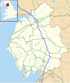
Location within Cumbria | |
| OS grid reference | SD386764 |
| Civil parish | |
| Unitary authority | |
| Ceremonial county | |
| Region | |
| Country | England |
| Sovereign state | United Kingdom |
| Post town | GRANGE-OVER-SANDS |
| Postcode district | LA11 |
| Dialling code | 015395 |
| Police | Cumbria |
| Fire | Cumbria |
| Ambulance | North West |
| UK Parliament | |
Allithwaite is a village in Cumbria, England, located roughly 1.2 miles (1.9 km) west of Grange-over-Sands. Within the boundaries of the historic county of Lancashire, Allithwaite, and the village of Cartmel situated to the north, are part of the civil parish of Lower Allithwaite. At the 2001 census, the parish had a population of 1,758, increasing to 1,831 at the 2011 Census.[1]
There is also a civil parish previously known as Upper Allithwaite which was renamed in 2018 as Lindale and Newton-in-Cartmel,[2] and includes Lindale, Low Newton and High Newton. The population of this parish at the 2011 Census was 843.[3]
Background and amenities
[edit]Most of the residents of Allithwaite commute to Ulverston, Barrow-in-Furness, Kendal or Lancaster to work.
The Anglican parish church is St. Mary's Church, built in 1864–65 and designed by the Lancaster architect Edward Graham Paley. There is a small primary school, Allithwaite Primary C of E School located next to the church. Both church and school were built by a legacy left to the village by Mary Lambert of Boarbank Hall.[4] The village also has a pub, a post office, a children's playground and a reasonably sized playing field with a tennis court, a pump track and a bowling green.[citation needed]
Wraysholme Tower
[edit]
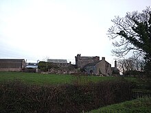
A mile to the south, Wraysholme Tower is a 15th-century pele tower, now in agricultural use, which abuts a farmhouse dating from the 19th century.[5] The tower was built by the Harrington family of Aldingham. A Michael Harrington acquired a grant of free warren in Aldingham in 1315. The tower, 40 feet (12 m) by 28 feet (8.5 m) and with walls 4 feet (1.2 m) thick at their base, is constructed from limestone rubble. There was originally an entrance at the north-west corner.[6] The roof is of slate.[7][8]
Boarbank Hall
[edit]
Boarbank Hall, to the west of the village, is a convent, nursing home and guest house, with a community of twelve Augustinian sisters and two Benedictine sisters.[9] There has been a house on the site since at least 1592, but the present house, in an Italian style, was built in 1870 after a fire had destroyed the previous frontage. The Augustinian Cannonesses acquired the house in 1921.[10][11][12] The Oratory, built in 1986, was the subject of an episode of BBC television's Building Sights, featuring architect Richard MacCormac, in 1991.[13]
Governance
[edit]Allithwaite lies within the Westmorland and Lonsdale parliamentary constituency, and its current MP is Tim Farron, former leader of the Liberal Democrats. Since 2023 the village has been part of the Westmorland and Furness Unitary Authority, replacing the former South Lakeland District Council.
See also
[edit]References
[edit]- ^ "Parish population 2011". Retrieved 12 June 2015.
- ^ "Change of parish name". Lindale and Newton in Cartmel Parish Council. Archived from the original on 13 May 2019. Retrieved 5 February 2020.
- ^ "Upper Allithwaite Civil Parish population 2011". Retrieved 25 January 2016.
- ^ Rowland, Pat (July 2013). "Mary Winfield Lambert". DOCSLIB.ORG. Retrieved 20 December 2023.
- ^ Historic England. "Wraysholme Tower (Grade II*) (1100320)". National Heritage List for England. Retrieved 17 September 2023.
- ^ Leslie Irving Gibson (1977). Lancashire Castles and Towers. Clapham, North Yorkshire: Dalesman Books. p. 48.
- ^ "Wraysholme Tower". Visit Cumbria. Retrieved 5 July 2015.
- ^ The Cumbrian Castle listing. (4 June 2006). "The castles, towers and fortified buildings of Cumbria: Wraysholme Tower, Allithwaite". Matthewpemmott.co.uk. Retrieved 5 July 2015.
- ^ "The community today". Boarbank Hall. Retrieved 22 June 2017.
- ^ "House and Gardens". Boarbank Hall. Retrieved 22 June 2017.
- ^ "History of the Canonesses". Boarbank Hall. Retrieved 22 June 2017.
- ^ "Mansion tells a tale of privilege and tragedy". Westmorland Gazette. 12 August 2010. Retrieved 22 June 2017.
- ^ "Building Sights: Series 3:12 Boarbank Hall Oratory". BBC iPlayer. Retrieved 22 June 2017.
External links
[edit] Media related to Allithwaite at Wikimedia Commons
- Cumbria County History Trust: Allithwaite, Lower (nb: provisional research only - see Talk page)
- Cumbria County History Trust: Allithwaite, Upper (nb: provisional research only - see Talk page)
- Allithwaite C of E Primary School

