Dereše: Difference between revisions
Appearance
Content deleted Content added
m number rounded |
|||
| (25 intermediate revisions by 22 users not shown) | |||
| Line 1: | Line 1: | ||
{{Infobox |
{{Infobox mountain |
||
| |
| name = Dereše |
||
| |
| photo = Derese2.jpg |
||
| |
| photo_caption = Dereše |
||
| |
| elevation_m = 2004 |
||
| elevation_ref = |
|||
| ⚫ | |||
| prominence = |
|||
| ⚫ | |||
| ⚫ | |||
| Prominence = |
|||
| ⚫ | |||
| |
| coordinates = {{coord|48|56|30|N|19|34|17|E}} |
||
| Topographic map = |
|||
| |
| topo = |
||
| first_ascent = |
|||
| |
| easiest_route = walk from [[Chopok]] |
||
| map_caption = Location in Slovakia |
|||
| map = Slovakia |
|||
}} |
}} |
||
| ⚫ | '''Dereše''' ({{langx|hu|Deres(original name)}}, 2,004 m) is the third highest peak of the [[Low Tatra]] range, in central [[Slovakia]]. It is located on the way between the highest mountains of the range, [[Ďumbier]] and [[Chopok]] in the east, and [[Chabenec]] in the west. Dereše is a popular destination among [[alpine skiing|alpine skiers]] despite a high risk of avalanches.<ref>{{cite peakware|id=2701|name=Dereše}}</ref> The scenic trail on the top of Dereše is surrounded by hundreds of [[cairn]]s. |
||
| ⚫ | '''Dereše''' (2,004 m) is the third highest peak of the [[Low Tatra]] range, in central [[Slovakia]]. It is located on the way between the highest mountains of the range, [[Ďumbier]] and [[Chopok]] |
||
==References== |
==References== |
||
<references /> |
<references /> |
||
{{DEFAULTSORT:Derese}} |
|||
| ⚫ | |||
| ⚫ | |||
{{Slovakia-geo-stub}} |
{{Slovakia-geo-stub}} |
||
| ⚫ | |||
| ⚫ | |||
Latest revision as of 05:11, 5 November 2024
| Dereše | |
|---|---|
 Dereše | |
| Highest point | |
| Elevation | 2,004 m (6,575 ft) |
| Coordinates | 48°56′30″N 19°34′17″E / 48.94167°N 19.57139°E |
| Geography | |
| Location | Slovakia |
| Parent range | Low Tatra |
| Climbing | |
| Easiest route | walk from Chopok |
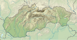
Dereše (Hungarian: Deres(original name), 2,004 m) is the third highest peak of the Low Tatra range, in central Slovakia. It is located on the way between the highest mountains of the range, Ďumbier and Chopok in the east, and Chabenec in the west. Dereše is a popular destination among alpine skiers despite a high risk of avalanches.[1] The scenic trail on the top of Dereše is surrounded by hundreds of cairns.
References
[edit]- ^ "Dereše". Peakware.com. Archived from the original on 2016-03-04.

