Barkarö: Difference between revisions
←Created page with '{{Infobox Settlement |official_name = Barkarö |image_skyline = |image_caption = |pushpin_map = Sweden |subdivision_type ...' |
mNo edit summary |
||
| (24 intermediate revisions by 16 users not shown) | |||
| Line 1: | Line 1: | ||
{{Infobox |
{{Infobox settlement |
||
|official_name = Barkarö |
|official_name = Barkarö |
||
|image_skyline = |
|image_skyline = Västerås-Barkarö kyrka.jpg |
||
|image_caption = |
|image_caption = Västerås-Barkarö Church in Barkarö |
||
|pushpin_map = Sweden |
|pushpin_map = Sweden Västmanland#Sweden |
||
|pushpin_label_position = |
|||
|subdivision_type = [[ |
|subdivision_type = [[Country]] |
||
|subdivision_name = [[Sweden]] |
|subdivision_name = [[Sweden]] |
||
| |
|subdivision_type3 = [[Municipalities of Sweden|Municipality]] |
||
| |
|subdivision_name3 = [[Västerås Municipality]] |
||
|subdivision_type2 = [[Counties of Sweden|County]] |
|subdivision_type2 = [[Counties of Sweden|County]] |
||
|subdivision_name2 = [[Västmanland County]] |
|subdivision_name2 = [[Västmanland County]] |
||
| |
|subdivision_type1 = [[Provinces of Sweden|Province]] |
||
| |
|subdivision_name1 = [[Västmanland]] |
||
|area_footnotes = <ref name= |
|area_footnotes = <ref name=scb>{{cite web|url=http://www.scb.se/Statistik/MI/MI0810/2010A01/Tatorternami0810tab1_4.xls |title=Tätorternas landareal, folkmängd och invånare per km<sup>2</sup> 2005 och 2010 |date=14 December 2011 |publisher=[[Statistics Sweden]] |language=Swedish |archiveurl=https://web.archive.org/web/20120127055525/http://www.scb.se/Statistik/MI/MI0810/2010A01/Tatorternami0810tab1_4.xls |archivedate=27 January 2012 |url-status=live |accessdate=10 January 2012 }}</ref> |
||
|area_total_km2 = 0. |
|area_total_km2 = 0.85 |
||
|population_as_of = |
|population_as_of = 31 December 2010 |
||
|population_footnotes = <ref name= |
|population_footnotes = <ref name=scb /> |
||
|population_total = |
|population_total = 1,163 <!-- This is the official figure from Statistics Sweden (Statistiska centralbyrån). --> |
||
|population_density_km2 = |
|population_density_km2 = 1366 |
||
|timezone = [[Central European Time|CET]] |
|timezone = [[Central European Time|CET]] |
||
|utc_offset = +1 |
|utc_offset = +1 |
||
|timezone_DST = [[Central European Summer Time|CEST]] |
|timezone_DST = [[Central European Summer Time|CEST]] |
||
|utc_offset_DST = +2 |
|utc_offset_DST = +2 |
||
|coordinates = {{coord|59|33|N|16|30|E|region:SE|display=inline,title}} |
|||
|latd=59 |latm=33 |lats= |latNS=N |
|||
|longd=16 |longm=30 |longs= |longEW=E |
|||
|website = |
|website = |
||
}} |
}} |
||
'''Barkarö''' is a [[urban areas of Sweden|locality]] |
'''Barkarö''' is a [[urban areas of Sweden|locality]] situated in [[Västerås Municipality]], [[Västmanland County]], [[Sweden]] with 1,163 inhabitants in 2010.<ref name=scb /> |
||
== History == |
|||
The Västerås-Barkarö parish had its origins in the Middle Ages but its name didn’t become Västerås-Barkarö until 1889. Its church probably dates to the turn of the 13th century. A fire in 1771 destroyed the church and it also devastated many of the buildings in its vicinity.<ref name=":0">{{Cite web |last=Jesper |date=2023-07-08 |title=Barkarö, Västmanland - Exploring Sweden |url=https://biveros.com/barkaro/ |access-date=2023-09-28 |website=Biveros Bulletin |language=en-GB}}</ref> |
|||
The Västerås-Barkarö parish was in operation until the Swedish Municipal Reform of 1862. This was when its responsibilities were split between the new civic government of Barkarö Municipality and the church congregation. The municipality was in 1952 incorporated into Dingtuna Municipality, which in turn became a part of the town of Västerås in 1967. The town became Västerås Municipality in 1971. The church congregation is today known as the Västerås-Barkarö Congregation.<ref name=":0" /> |
|||
== Things to Do and See == |
|||
The locality mostly consists of residential areas with the yellow stone church on its southern outskirts. It has good transport connections to the nearby city of Västerås and has Lake Mälaren both to the south and to the east. The lake is the third largest in Sweden.<ref name=":0" /> |
|||
== References == |
== References == |
||
{{Reflist}} |
{{Reflist}} |
||
| ⚫ | |||
{{coor title dm|59|33|N|16|30|E}} |
|||
{{authority control}} |
|||
| ⚫ | |||
{{DEFAULTSORT:Barkaro}} |
|||
| ⚫ | |||
| ⚫ | |||
[[Category:Populated places in Västerås Municipality]] |
|||
| ⚫ | |||
| ⚫ | |||
[[sv:Barkarö]] |
|||
Latest revision as of 13:31, 28 September 2023
Barkarö | |
|---|---|
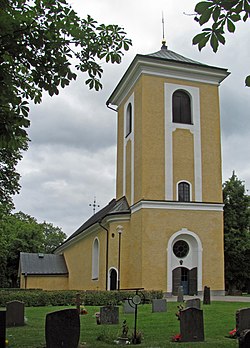
 Västerås-Barkarö Church in Barkarö | |
| Coordinates: 59°33′N 16°30′E / 59.550°N 16.500°E | |
| Country | Sweden |
| Province | Västmanland |
| County | Västmanland County |
| Municipality | Västerås Municipality |
| Area | |
• Total | 0.85 km2 (0.33 sq mi) |
| Population (31 December 2010)[1] | |
• Total | 1,163 |
| • Density | 1,366/km2 (3,540/sq mi) |
| Time zone | UTC+1 (CET) |
| • Summer (DST) | UTC+2 (CEST) |
Barkarö is a locality situated in Västerås Municipality, Västmanland County, Sweden with 1,163 inhabitants in 2010.[1]
History
[edit]The Västerås-Barkarö parish had its origins in the Middle Ages but its name didn’t become Västerås-Barkarö until 1889. Its church probably dates to the turn of the 13th century. A fire in 1771 destroyed the church and it also devastated many of the buildings in its vicinity.[2]
The Västerås-Barkarö parish was in operation until the Swedish Municipal Reform of 1862. This was when its responsibilities were split between the new civic government of Barkarö Municipality and the church congregation. The municipality was in 1952 incorporated into Dingtuna Municipality, which in turn became a part of the town of Västerås in 1967. The town became Västerås Municipality in 1971. The church congregation is today known as the Västerås-Barkarö Congregation.[2]
Things to Do and See
[edit]The locality mostly consists of residential areas with the yellow stone church on its southern outskirts. It has good transport connections to the nearby city of Västerås and has Lake Mälaren both to the south and to the east. The lake is the third largest in Sweden.[2]
References
[edit]- ^ a b c "Tätorternas landareal, folkmängd och invånare per km2 2005 och 2010" (in Swedish). Statistics Sweden. 14 December 2011. Archived from the original on 27 January 2012. Retrieved 10 January 2012.
- ^ a b c Jesper (2023-07-08). "Barkarö, Västmanland - Exploring Sweden". Biveros Bulletin. Retrieved 2023-09-28.


