Ashlu Falls: Difference between revisions
Appearance
Content deleted Content added
Template |
Volcanoguy (talk | contribs) added BC waterfalls list |
||
| (23 intermediate revisions by 16 users not shown) | |||
| Line 1: | Line 1: | ||
{{Cite check|date= April 2009}} |
|||
{{Article issues |
|||
| ⚫ | |||
| or = March 2009 |
|||
| ⚫ | |||
| citations missing = March 2009 |
|||
| |
| photo = Ashlu Falls.jpg |
||
| photo_width = |
|||
}} |
|||
| photo_caption = |
|||
| ⚫ | |||
| ⚫ | |||
| ⚫ | |||
| coords = {{coord|49|56|01|N|123|21|31|W|}} |
|||
| image = |
|||
| |
| elevation = |
||
| ⚫ | |||
| caption = |
|||
| ⚫ | |||
| ⚫ | |||
| ⚫ | |||
| latitude = |
|||
| longitude = |
|||
| coordinates = |
|||
| elevation = |
|||
| ⚫ | |||
| ⚫ | |||
| ⚫ | |||
| height_longest = {{convert|20|ft|m}} |
| height_longest = {{convert|20|ft|m}} |
||
| average_width |
| average_width = |
||
| number_drops |
| number_drops = 2 |
||
| average_flow |
| average_flow = |
||
| watercourse |
| watercourse = [[Ashlu Creek]] |
||
| world_rank |
| world_rank = |
||
| footnotes = |
|||
}} |
}} |
||
'''Ashlu Falls''' is a short but significant waterfall along lower [[Ashlu Creek]]. The falls are located about 6 |
'''Ashlu Falls''' is a short but significant waterfall along lower [[Ashlu Creek]]. The falls are located about 6 km above the mouth of Ashlu Creek and mark the head of Ashlu Canyon. The creek is actually crossed by a [[logging road]] bridge between the two tiers.<ref>[http://www.waterfallsnorthwest.com/bc_waterfall.php?num=48&p=0 Waterfalls of the Pacific Northwest: Ashlu Falls]</ref> |
||
== Stature == |
== Stature == |
||
| ⚫ | Ashlu Falls stands a total of 33 feet in height. The upper drop is about 10 feet high & its width is over 10 times its height. The creek then flows under the bridge & bends before then dropping another 20 feet or so through a narrow chute into a deep pool. On the north side of the lower drop is a large section of sculptured rock that, when the creek is high, is completely covered with water, making the lower tier roughly as wide as the upper tier. |
||
==See also== |
|||
| ⚫ | Ashlu Falls stands |
||
*[[List of waterfalls in British Columbia]] |
|||
== References == |
== References == |
||
{{reflist}} |
{{reflist}} |
||
{{coord|49|56|01|N|123|21|31|W|display=title}} |
|||
[[Category:Waterfalls of British Columbia]] |
[[Category:Waterfalls of British Columbia]] |
||
[[Category:New Westminster Land District]] |
|||
Latest revision as of 22:07, 5 November 2023
| Ashlu Falls | |
|---|---|
 | |
 | |
| Location | Northwest of Squamish |
| Coordinates | 49°56′01″N 123°21′31″W / 49.93361°N 123.35861°W |
| Type | Tiered |
| Total height | 33 feet (10 m) |
| Number of drops | 2 |
| Longest drop | 20 feet (6.1 m) |
| Total width | 108 feet (33 m) |
| Watercourse | Ashlu Creek |
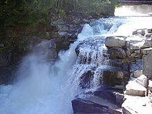
Ashlu Falls is a short but significant waterfall along lower Ashlu Creek. The falls are located about 6 km above the mouth of Ashlu Creek and mark the head of Ashlu Canyon. The creek is actually crossed by a logging road bridge between the two tiers.[1]
Stature
[edit]Ashlu Falls stands a total of 33 feet in height. The upper drop is about 10 feet high & its width is over 10 times its height. The creek then flows under the bridge & bends before then dropping another 20 feet or so through a narrow chute into a deep pool. On the north side of the lower drop is a large section of sculptured rock that, when the creek is high, is completely covered with water, making the lower tier roughly as wide as the upper tier.
