Lauro Müller, Santa Catarina: Difference between revisions
Appearance
Content deleted Content added
m Unlinking full-dates. Details here. Codes: AMreg(×2) |
No edit summary |
||
| (30 intermediate revisions by 24 users not shown) | |||
| Line 6: | Line 6: | ||
|imagesize = 250px |
|imagesize = 250px |
||
|image_caption = |
|image_caption = |
||
|image_flag = |
|image_flag = Bandeira-lauro_müller.png |
||
|image_seal = |
|image_seal = Brasao_lauromuller.png |
||
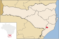
|image_map = SantaCatarina_Municip_LauroMuller.svg |
|image_map = SantaCatarina_Municip_LauroMuller.svg |
||
|mapsize = 250px |
|mapsize = 250px |
||
| Line 18: | Line 18: | ||
|subdivision_name2 = {{flagicon|Santa Catarina}} [[Santa Catarina (state)|Santa Catarina]] |
|subdivision_name2 = {{flagicon|Santa Catarina}} [[Santa Catarina (state)|Santa Catarina]] |
||
|leader_title = Mayor |
|leader_title = Mayor |
||
|leader_name = |
|leader_name = Saionara Correa de Carvalho Bora |
||
|leader_party = |
|leader_party = |
||
|leader_title1 = |
|leader_title1 = |
||
| Line 45: | Line 45: | ||
|area_metro_sq_mi = |
|area_metro_sq_mi = |
||
|pushpin_map = Brazil |
|pushpin_map = Brazil |
||
|population_as_of = |
|population_as_of = 2020 <ref>[https://cidades.ibge.gov.br/brasil/sc/lauro-muller/panorama IBGE 2020]</ref> |
||
|population_note = |
|population_note = |
||
|population_total = |
|population_total = 15,313 |
||
|population_density_km2 = 49.4 |
|population_density_km2 = 49.4 |
||
|population_density_sq_mi = |
|population_density_sq_mi = |
||
| Line 59: | Line 59: | ||
|timezone_DST = [[UTC-2]] |
|timezone_DST = [[UTC-2]] |
||
|utc_offset_DST = -2 |
|utc_offset_DST = -2 |
||
|coordinates = {{coord|28|23|34|S|49|23|49|W|region:BR|display=inline,title}} |
|||
|latd=28 |latm=23 |lats=34 |latNS=S |
|||
|longd=49 |longm=23 |longs=49 |longEW=W |
|||
|elevation_m = 220 |
|elevation_m = 220 |
||
|elevation_ft = |
|elevation_ft = |
||
| Line 70: | Line 69: | ||
}} |
}} |
||
'''Lauro Müller''' is a [[city]] in [[Santa Catarina (state)|Santa Catarina]], in the [[Southern Brazil|Southern Region]] of [[Brazil]]. |
'''Lauro Müller''' is a [[city]] in [[Santa Catarina (state)|Santa Catarina]], in the [[Southern Brazil|Southern Region]] of [[Brazil]]. |
||
== History == |
== History == |
||
Despite its [[German Language|German]] name, the city was |
Despite its [[German Language|German]] name, the city was settled by Italians at the end of the 19th century. The settlements extensive coal deposits were first exploited in 1827, however the area's economy only begun to develop after the arrival of Italian immigrants. |
||
On September 25, 1905, the engineer [[Álvaro Rodovalho Marcondes do Reis]] proposed to give the area the name |
On September 25, 1905, the engineer [[Álvaro Rodovalho Marcondes do Reis]] proposed to give the area the name 'Lauro Müller', in appreciation of the ''Ministro da Viação e Obras Públicas'' (secretary of Industry, Transport and Public Works) [[Lauro Müller|Dr. Lauro Severiano Müller]]. Müller was an engineer and diplomat in addition to serving two terms as President of Santa Catarina. |
||
==References== |
|||
{{Reflist}} |
|||
{{Santa_Catarina_MesoRegion_Sul_Catarinense}} |
{{Santa_Catarina_MesoRegion_Sul_Catarinense}} |
||
{{DEFAULTSORT:Lauro Muller, Santa Catarina}} |
{{DEFAULTSORT:Lauro Muller, Santa Catarina}} |
||
[[Category: |
[[Category:Municipalities in Santa Catarina (state)]] |
||
[[Category: |
[[Category:Populated places established in 1956]] |
||
[[Category:1956 establishments in Brazil]] |
|||
{{SantaCatarina-geo-stub}} |
{{SantaCatarina-geo-stub}} |
||
[[fr:Lauro Müller (Santa Catarina)]] |
|||
[[bpy:লৌরো মুললয়ের]] |
|||
[[ia:Lauro Müller (Santa Catarina)]] |
|||
[[it:Lauro Müller (Santa Catarina)]] |
|||
[[no:Lauro Müller]] |
|||
[[pt:Lauro Müller (Santa Catarina)]] |
|||
[[ro:Lauro Muller]] |
|||
[[ru:Лауру-Мюллер (Санта-Катарина)]] |
|||
[[vo:Lauro Müller]] |
|||
Latest revision as of 20:03, 12 March 2024
Lauro Müller | |
|---|---|
 Location of Lauro Müller | |
| Coordinates: 28°23′34″S 49°23′49″W / 28.39278°S 49.39694°W | |
| Country | |
| Region | South |
| State | |
| Founded | December 6, 1956 |
| Government | |
| • Mayor | Saionara Correa de Carvalho Bora |
| Area | |
• Total | 270.508 km2 (104.444 sq mi) |
| Elevation | 220 m (720 ft) |
| Population (2020 [1]) | |
• Total | 15,313 |
| • Density | 49.4/km2 (128/sq mi) |
| Time zone | UTC-3 (UTC-3) |
| • Summer (DST) | UTC-2 (UTC-2) |
| HDI (2000) | 0.800 |
| Website | www.lauromuller.sc.gov.br |
Lauro Müller is a city in Santa Catarina, in the Southern Region of Brazil.
History
[edit]Despite its German name, the city was settled by Italians at the end of the 19th century. The settlements extensive coal deposits were first exploited in 1827, however the area's economy only begun to develop after the arrival of Italian immigrants.
On September 25, 1905, the engineer Álvaro Rodovalho Marcondes do Reis proposed to give the area the name 'Lauro Müller', in appreciation of the Ministro da Viação e Obras Públicas (secretary of Industry, Transport and Public Works) Dr. Lauro Severiano Müller. Müller was an engineer and diplomat in addition to serving two terms as President of Santa Catarina.
References
[edit]


