Eduardo Falla Solano Airport: Difference between revisions
Appearance
Content deleted Content added
No edit summary |
|||
| (18 intermediate revisions by 18 users not shown) | |||
| Line 1: | Line 1: | ||
{{Infobox |
{{Infobox airport |
||
| name = Eduardo Falla Solano Airport |
| name = Eduardo Falla Solano Airport |
||
| nativename = Aeropuerto Eduardo Falla Solano |
| nativename = Aeropuerto Nacional Eduardo Falla Solano |
||
| image = |
| image = |
||
| IATA = SVI |
| IATA = SVI |
||
| ICAO = SKSV |
| ICAO = SKSV |
||
| pushpin_map = Colombia |
|||
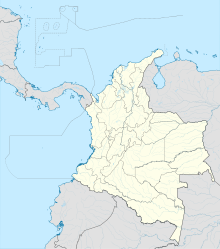
| pushpin_map_caption = Location of airport in Colombia |
|||
| pushpin_label = '''SVI''' |
|||
| type = Public |
| type = Public |
||
| owner = |
| owner = [[Aerocivil]] |
||
| operator = |
| operator = |
||
| city-served = |
| city-served = [[San Vicente del Caguán]], [[Colombia]] |
||
| location = |
| location = |
||
| elevation-f = |
| elevation-f = 883 |
||
| elevation-m = |
| elevation-m = |
||
| coordinates = {{coord| |
| coordinates = {{coord|2|09|05|N|74|45|55|W|type:airport}} |
||
| website = |
| website = |
||
| metric-rwy = y |
| metric-rwy = y |
||
| r1-number = 14/32 |
| r1-number = 14/32 |
||
| r1-length-m = |
| r1-length-m = 1500 |
||
| r1-length-f = |
| r1-length-f = |
||
| r1-surface = |
| r1-surface = Asphalt |
||
| |
| stat-year = |
||
| stat1-header = |
|||
| stat1-data = |
|||
| stat2-header = |
|||
| stat2-data = |
|||
| stat3-header = |
|||
| stat3-data = |
|||
| footnotes = Sources: GCM<ref>{{GCM|SVI}}</ref> Google Maps<ref>[https://www.google.com/maps/@2.1523822,-74.7671889,2603m/data=!3m1!1e3 Google Maps - San Vicente]</ref> |
|||
}} |
}} |
||
'''Eduardo Falla Solano Airport''' {{airport codes|SVI|SKSV}} in {{ |
'''Eduardo Falla Solano Airport''' {{airport codes|SVI|SKSV}} in {{langx|es|Aeropuerto Eduardo Falla Solano}} is a domestic airport serving the municipality of [[San Vicente del Caguán]] in the [[Caquetá Department]] of [[Colombia]]. |
||
The runway is {{convert|4|km}} north of the airport. The San Vicente Del Caguan [[VOR-DME]] (Ident: '''SVC''') and [[non-directional beacon]] (Ident: '''SVC''') are located on the field.<ref>[http://ourairports.com/navaids/SVC/San_Vicente_Del_Caguan_VOR-DME_CO/#lat=2.148329973220825,lon=-74.76309967041016,zoom=10,type=Satellite San Vincente VOR]</ref><ref>[https://skyvector.com/airport/SKSV/San-Vincente-Airport SkyVector - San Vicente NDB]</ref> |
|||
== Airlines and destinations == |
== Airlines and destinations == |
||
<!-- Please use only independent sources. The airport and the airline itself are not independent sources. --> |
|||
*[[SATENA]] (Neiva, Bogota) |
|||
{{Airport-dest-list |
|||
| [[SATENA]] | [[Araracuara Airport|Araracuara]], [[El Dorado International Airport|Bogotá]], [[Benito Salas Airport|Neiva]]<ref>{{cite web |title=SATENA late-Sep/Oct 2024 New Routes Addition |url=https://www.aeroroutes.com/eng/240909-9rsep24 |website=Aeroroutes |access-date=9 September 2024}}</ref> |
|||
}} |
|||
==Accidents and incidents== |
==Accidents and incidents== |
||
On 17 October 1971, [[Douglas C-47|Douglas C-47A]] HK-595 of |
On 17 October 1971, [[Douglas C-47|Douglas C-47A]] HK-595 of Aerolíneas TAO<ref>[https://asn.flightsafety.org/database/operators/9044 TAO Airlines closed]</ref> crashed on take-off, killing 19 of 21 people on board. The aircraft was operating a domestic non-scheduled passenger flight although it was only certified to carry freight and three crew. It was also overloaded by {{convert|311|kg|lb}}.<ref name=ASN171071>{{cite web|url=https://asn.flightsafety.org/asndb/330705 |title=HK-595 Accident description |publisher=Aviation Safety Network |access-date=28 April 2021}}</ref> |
||
==See also== |
|||
*[[Transport in Colombia]] |
|||
*[[List of airports in Colombia]] |
|||
==References== |
==References== |
||
| Line 34: | Line 53: | ||
== External links == |
== External links == |
||
*[https://www.openstreetmap.org/#map=13/2.1518/-74.7651 OpenStreetMap - San Vicente] |
|||
| ⚫ | |||
*[http://ourairports.com/airports/SKSV/pilot-info.html#general OurAirports - San Vicente] |
|||
*[http://www.fallingrain.com/icao/SKSV.html FallingRain - San Vicente Airport] |
|||
| ⚫ | |||
{{Colombia |
{{portalbar|Colombia|Aviation}} |
||
{{Airports |
{{Airports in Colombia|state=collapsed}} |
||
{{authority control}} |
|||
[[Category:Airports in Colombia]] |
[[Category:Airports in Colombia]] |
||
[[Category:Buildings and structures in Caquetá Department]] |
|||
[[es:Aeropuerto Eduardo Falla Solano]] |
|||
{{Colombia-airport-stub}} |
|||
[[nl:Luchthaven Eduardo Falla Solano]] |
|||
Latest revision as of 05:28, 25 October 2024
Eduardo Falla Solano Airport Aeropuerto Nacional Eduardo Falla Solano | |||||||||||
|---|---|---|---|---|---|---|---|---|---|---|---|
| Summary | |||||||||||
| Airport type | Public | ||||||||||
| Owner | Aerocivil | ||||||||||
| Serves | San Vicente del Caguán, Colombia | ||||||||||
| Elevation AMSL | 883 ft / 269 m | ||||||||||
| Coordinates | 2°09′05″N 74°45′55″W / 2.15139°N 74.76528°W | ||||||||||
| Map | |||||||||||
 | |||||||||||
| Runways | |||||||||||
| |||||||||||
Eduardo Falla Solano Airport (IATA: SVI, ICAO: SKSV) in Spanish: Aeropuerto Eduardo Falla Solano is a domestic airport serving the municipality of San Vicente del Caguán in the Caquetá Department of Colombia.
The runway is 4 kilometres (2.5 mi) north of the airport. The San Vicente Del Caguan VOR-DME (Ident: SVC) and non-directional beacon (Ident: SVC) are located on the field.[3][4]
Airlines and destinations
[edit]| Airlines | Destinations |
|---|---|
| SATENA | Araracuara, Bogotá, Neiva[5] |
Accidents and incidents
[edit]On 17 October 1971, Douglas C-47A HK-595 of Aerolíneas TAO[6] crashed on take-off, killing 19 of 21 people on board. The aircraft was operating a domestic non-scheduled passenger flight although it was only certified to carry freight and three crew. It was also overloaded by 311 kilograms (686 lb).[7]
See also
[edit]References
[edit]- ^ Airport information for SVI at Great Circle Mapper.
- ^ Google Maps - San Vicente
- ^ San Vincente VOR
- ^ SkyVector - San Vicente NDB
- ^ "SATENA late-Sep/Oct 2024 New Routes Addition". Aeroroutes. Retrieved 9 September 2024.
- ^ TAO Airlines closed
- ^ "HK-595 Accident description". Aviation Safety Network. Retrieved 28 April 2021.
External links
[edit]- OpenStreetMap - San Vicente
- OurAirports - San Vicente
- FallingRain - San Vicente Airport
- Accident history for SVI at Aviation Safety Network

