R668 road (Ireland): Difference between revisions
Appearance
Content deleted Content added
m O'Dea moved page R668 road to R668 road (Ireland): Standard regional road title format |
|||
| (16 intermediate revisions by 12 users not shown) | |||
| Line 1: | Line 1: | ||
{{Short description|Road in Ireland}} |
|||
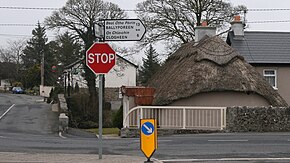
[[File:Ballylooby4.JPG|thumb|400px|R668 through Ballylooby]] |
|||
{{Use dmy dates|date=October 2021}} |
|||
{{Use Irish English|date=October 2021}} |
|||
{{Infobox road |
|||
| country = IRL |
|||
| type = R |
|||
| image = Ballylooby4.JPG |
|||
| image_notes = R668 through Ballylooby |
|||
| route = 668 |
|||
| length_km = |
|||
| length_ref = |
|||
| terminus_a = [[File:IRL R913.svg|x20px]] [[R913 road (Ireland)|R913]] at Mitchelstown Road, [[Cahir]], [[County Tipperary]] |
|||
| junction = |
|||
{{plainlist | |
|||
*[[File:IRL R665.svg|x20px]] [[R665 road (Ireland)|R665]] at Parsons Green |
|||
*Enter [[County Waterford]] |
|||
}} |
|||
| terminus_b = [[File:IRL N72.svg|x20px]] [[N72 road (Ireland)|N72]] at Ballyrafter |
|||
| previous_type = R |
|||
| previous_route = 667 |
|||
| next_type = R |
|||
| next_route = 669 |
|||
}} |
|||
The '''R668 road''' is a [[regional road]] in [[Republic of Ireland|Ireland]] |
The '''R668 road''' is a [[Regional road (Ireland)|regional road]] in [[Republic of Ireland|Ireland]] from [[Lismore, County Waterford]] to [[Cahir]] in [[County Tipperary]], through [[Clogheen, County Tipperary|Clogheen]] and [[Ballylooby]]. The Lismore–Clogheen section is a [[scenic route]] through the '''Vee Gap''' ({{langx|ga|Bóthar na gCorr}}<ref>{{cite web|url=http://logainm.ie/1167408.aspx|title=Bóthar na gCorr / The Vee|work=[[Placenames Database of Ireland]]|access-date=24 June 2012}}</ref>) in the [[Knockmealdown Mountains]], between [[Sugarloaf Hill]] and Knockshanahullion.<ref>{{cite web|url=http://maps.osi.ie/publicviewer/#V1,604241,611894,5,1|title=604241,611894|publisher=Ordnance Survey Ireland|work=Mapviewer|access-date=24 June 2012}}</ref> |
||
In the eighteenth century, the Cahir–Clogheen section was part of the main road from [[Cashel, County Tipperary|Cashel]] to [[Cork (city)|Cork city]].<ref>{{cite web |url=http://www.askaboutireland.ie/reading-room/digital-book-collection/digital-books-by-subject/geography-of-ireland/taylor-skinner-maps-of-th/ |last=Taylor |first=George |author2=Andrew Skinner |title=Maps of the Roads of Ireland, surveyed 1777 |location=London |publisher=G. Terry |year=1778 |access-date=24 June 2012}}</ref> It was superseded in the early 19th century by the construction of [[R639|what is now the R639 road]] between Cahir and [[Mitchelstown]]. |
|||
==See also== |
|||
*[[Roads in Ireland]] |
|||
The [[R665 road (Ireland)|R665]] crosses the R668 at Clogheen.<ref>{{cite web|url=http://maps.osi.ie/publicviewer/#V1,600325,614116,5,1|title=600325,614116|work=Mapviewer|publisher=Ordnance Survey Ireland|access-date=24 June 2012}}</ref> At Glentanagree Bridge, the [[R669 road (Ireland)|R669]] forks off to the south east past [[Mount Melleray]] to [[Cappoquin]].<ref>{{cite web|url=http://maps.osi.ie/publicviewer/#V1,603998,607814,5,1|title=603998,607814|work=Mapviewer|publisher=Ordnance Survey Ireland|access-date=24 June 2012}}</ref> |
|||
*[[Motorways in Ireland]] |
|||
*[[National primary road]] |
|||
*[[National secondary road]] |
|||
*[[Trunk Roads in Ireland]] |
|||
*[[History of roads in Ireland]] |
|||
==References== |
==References== |
||
{{reflist}} |
{{reflist}} |
||
*[http://www.transport.ie/upload/general/7617-0.pdf Roads Act 1993 (Classification of Regional Roads) Order 2006] – [[Department of Transport (Ireland)|Department of Transport]] |
*[https://web.archive.org/web/20070927005411/http://www.transport.ie/upload/general/7617-0.pdf Roads Act 1993 (Classification of Regional Roads) Order 2006] – [[Department of Transport (Ireland)|Department of Transport]] |
||
{{Roads in Ireland}} |
{{Roads in Ireland}} |
||
| Line 20: | Line 38: | ||
[[Category:Regional roads in the Republic of Ireland]] |
[[Category:Regional roads in the Republic of Ireland]] |
||
[[Category:Roads in County Tipperary]] |
[[Category:Roads in County Tipperary]] |
||
[[Category:Roads in County Waterford]] |
|||
Latest revision as of 18:49, 5 November 2024
| R668 road | ||||
|---|---|---|---|---|
| Bóthar R668 | ||||
 R668 through Ballylooby | ||||
| Major junctions | ||||
| From | ||||
| ||||
| To | ||||
| Location | ||||
| Country | Ireland | |||
| Highway system | ||||
| ||||
The R668 road is a regional road in Ireland from Lismore, County Waterford to Cahir in County Tipperary, through Clogheen and Ballylooby. The Lismore–Clogheen section is a scenic route through the Vee Gap (Irish: Bóthar na gCorr[1]) in the Knockmealdown Mountains, between Sugarloaf Hill and Knockshanahullion.[2]
In the eighteenth century, the Cahir–Clogheen section was part of the main road from Cashel to Cork city.[3] It was superseded in the early 19th century by the construction of what is now the R639 road between Cahir and Mitchelstown.
The R665 crosses the R668 at Clogheen.[4] At Glentanagree Bridge, the R669 forks off to the south east past Mount Melleray to Cappoquin.[5]
References
[edit]- ^ "Bóthar na gCorr / The Vee". Placenames Database of Ireland. Retrieved 24 June 2012.
- ^ "604241,611894". Mapviewer. Ordnance Survey Ireland. Retrieved 24 June 2012.
- ^ Taylor, George; Andrew Skinner (1778). "Maps of the Roads of Ireland, surveyed 1777". London: G. Terry. Retrieved 24 June 2012.
- ^ "600325,614116". Mapviewer. Ordnance Survey Ireland. Retrieved 24 June 2012.
- ^ "603998,607814". Mapviewer. Ordnance Survey Ireland. Retrieved 24 June 2012.

