McDonalds Mill, Virginia: Difference between revisions
Appearance
Content deleted Content added
Short description |
|||
| (16 intermediate revisions by 11 users not shown) | |||
| Line 1: | Line 1: | ||
{{Short description|Unincorporated community in Virginia, United States}} |
|||
{{unreferenced|date=September 2010}} |
|||
{{Use mdy dates|date=July 2023}} |
|||
{{Infobox settlement |
{{Infobox settlement |
||
|official_name = McDonalds Mill, Virginia |
|official_name = McDonalds Mill, Virginia |
||
|settlement_type = [[Unincorporated community]] |
|settlement_type = [[Unincorporated community]] |
||
|nickname = |
|nickname = |
||
|motto = |
|motto = |
||
<!-- Images --> |
<!-- Images --> |
||
|image_skyline = |
|image_skyline = McDonalds Mill 01.jpg |
||
|imagesize = |
|imagesize = 280px |
||
|image_caption = |
|image_caption = Historic McDonalds Mill |
||
|image_flag = |
|image_flag = |
||
|image_seal = |
|image_seal = |
||
<!-- Maps --> |
<!-- Maps --> |
||
| ⚫ | |||
|image_map = |
|||
|pushpin_label = McDonalds{{nbsp}}Mill |
|||
|mapsize = |
|||
|map_caption = |
|||
| ⚫ | |||
|pushpin_label_position = none<!-- the position of the pushpin label: left, right, top, bottom, none --> |
|||
|pushpin_map_caption = Location within the Commonwealth of Virginia |
|||
<!-- Location --> |
<!-- Location --> |
||
|coordinates = {{coord|37|18|00|N|80|16|32|W|region:US-VA|display=inline,title}} |
|||
| latd = 37 |latm = 18 |lats = 00 |latNS = N |
|||
| ⚫ | |||
| longd = 80 |longm = 16 |longs = 32 |longEW = W |
|||
| |
|subdivision_name = United States |
||
| |
|subdivision_type1 = [[U.S. state|State]] |
||
| ⚫ | |||
|subdivision_name = [[United States]] |
|||
|subdivision_type1 = [[Political divisions of the United States|State]] |
|||
|subdivision_name1 = [[Virginia]] |
|subdivision_name1 = [[Virginia]] |
||
|subdivision_type2 = [[List of counties in Virginia|County]] |
|subdivision_type2 = [[List of counties in Virginia|County]] |
||
| Line 41: | Line 35: | ||
|leader_name1 = |
|leader_name1 = |
||
|established_title = |
|established_title = |
||
|established_date = |
|established_date = |
||
<!-- Area --> |
<!-- Area --> |
||
| Line 52: | Line 46: | ||
|area_total_sq_mi = |
|area_total_sq_mi = |
||
|area_land_sq_mi = |
|area_land_sq_mi = |
||
|area_water_sq_mi = |
|area_water_sq_mi = |
||
<!-- Population --> |
<!-- Population --> |
||
| Line 59: | Line 53: | ||
|population_total = |
|population_total = |
||
|population_density_km2 = |
|population_density_km2 = |
||
|population_density_sq_mi = |
|population_density_sq_mi = |
||
}} |
}} |
||
'''McDonalds Mill''' is an [[Unincorporated area|unincorporated community]] in the northeastern section of [[Montgomery County, Virginia]]. Located approximately 10 miles east of [[Blacksburg, Virginia]] along State Route 785, McDonalds Mill lies at the floor of the [[Catawba Valley]] and is bound on the south by [[Paris Mountain]] and to the north by [[Gallion Ridge]]. |
'''McDonalds Mill'''<ref>{{GNIS|1495916}}</ref> is an [[Unincorporated area|unincorporated community]] in the northeastern section of [[Montgomery County, Virginia]]. Located approximately 10 miles east of [[Blacksburg, Virginia]] along State Route 785, McDonalds Mill lies at the floor of the [[Catawba Valley]] and is bound on the south by [[Paris Mountain]] and to the north by [[Gallion Ridge]]. |
||
==History== |
==History== |
||
A post office called McDonalds Mills operated from 1847 until 1913.<ref>{{cite web | url=http://www.postalhistory.com/postoffices.asp?task=display&state=VA&county=Montgomery&searchtext=&pagenum=3 | title=Montgomery County | publisher=Jim Forte Postal History | accessdate=28 September 2014}}</ref> George McDonald operated a mill there, hence the name.<ref>{{cite book|last=Tennis|first=Joe|title=Southwest Virginia Crossroads: An Almanac of Place Names and Places to See|url=https://books.google.com/books?id=noiiZPTGk9IC&pg=PA140|year=2004|publisher=The Overmountain Press|isbn=978-1-57072-256-1|page=140}}</ref> |
|||
The current McDonald's Mill was built in 1861. The current owners, Ned and Janet Yost, want to preserve the mill and the land around it so that others can get a glimpse of life on the North Fork of the [[Roanoke River]] as it was when the region was first occupied by immigrants from the [[British Isles]]. The origin of the creek that eventually becomes the Roanoke River is just a few miles from the mill. The fledgling stream gathered water quickly from springs and hollows and in a short distance, was big enough to make a [[mill pond]] inside the current Montgomery County line. The stream was dammed and a race was constructed of lumber sawed for nearby forest to carry the water to the top of the [[mill wheel]] several hundred yards downstream. According to Yost, the mill was established in the 1790s and was operated by five generations of McDonalds. Two buildings preceded the current structure that Yost's parents purchased in 1952. |
|||
==References== |
==References== |
||
| Line 72: | Line 66: | ||
{{Montgomery County, Virginia}} |
{{Montgomery County, Virginia}} |
||
{{authority control}} |
|||
{{DEFAULTSORT:Mcdonalds Mill, Virginia}} |
{{DEFAULTSORT:Mcdonalds Mill, Virginia}} |
||
[[Category: |
[[Category:Unincorporated communities in Montgomery County, Virginia]] |
||
[[Category:Unincorporated communities in Virginia]] |
[[Category:Unincorporated communities in Virginia]] |
||
Latest revision as of 23:33, 31 May 2024
McDonalds Mill, Virginia | |
|---|---|
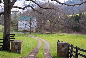
 Historic McDonalds Mill | |
| Coordinates: 37°18′00″N 80°16′32″W / 37.30000°N 80.27556°W | |
| Country | United States |
| State | Virginia |
| County | Montgomery |
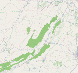
McDonalds Mill[1] is an unincorporated community in the northeastern section of Montgomery County, Virginia. Located approximately 10 miles east of Blacksburg, Virginia along State Route 785, McDonalds Mill lies at the floor of the Catawba Valley and is bound on the south by Paris Mountain and to the north by Gallion Ridge.
History
[edit]A post office called McDonalds Mills operated from 1847 until 1913.[2] George McDonald operated a mill there, hence the name.[3]
References
[edit]- ^ U.S. Geological Survey Geographic Names Information System: McDonalds Mill, Virginia
- ^ "Montgomery County". Jim Forte Postal History. Retrieved September 28, 2014.
- ^ Tennis, Joe (2004). Southwest Virginia Crossroads: An Almanac of Place Names and Places to See. The Overmountain Press. p. 140. ISBN 978-1-57072-256-1.


