Montchaude: Difference between revisions
Appearance
Content deleted Content added
m Bot: Migrating 18 interwiki links, now provided by Wikidata on d:q1626512 (Report Errors) |
RodRabelo7 (talk | contribs) |
||
| (10 intermediate revisions by 7 users not shown) | |||
| Line 1: | Line 1: | ||
{{Infobox French commune |
{{Infobox French commune |
||
|name = Montchaude |
|name = Montchaude |
||
|image = |
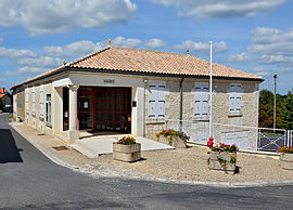
|image = Montchaude 16 Mairie 2013.jpg |
||
|caption = Town hall |
|caption = Town hall |
||
|region = Poitou-Charentes |
|||
|department = Charente |
|||
|arrondissement = Cognac |
|arrondissement = Cognac |
||
|canton = |
|canton = Charente-Sud |
||
|INSEE = 16224 |
|INSEE = 16224 |
||
|postal code = 16300 |
|postal code = 16300 |
||
| |
|commune = [[Montmérac]] |
||
|coordinates = {{coord|45.4486|-.19972|format=dms|display=inline,title}} |
|||
|term = 2008–2014 |
|||
|intercommunality = 3B - Sud-Charente |
|||
|longitude = -.19972 |
|||
|latitude = 45.4486 |
|||
|elevation m = 145 |
|elevation m = 145 |
||
|elevation min m = 61 |
|elevation min m = 61 |
||
|elevation max m = 147 |
|elevation max m = 147 |
||
|area km2 = 14.18 |
|area km2 = 14.18 |
||
|population = |
|population = 490 |
||
|population date = |
|population date = 2019 |
||
|population footnotes = <ref name=pop2019>[https://www.insee.fr/fr/statistiques/fichier/6011070/ensemble.pdf Téléchargement du fichier d'ensemble des populations légales en 2019], [[Institut national de la statistique et des études économiques|INSEE]]</ref> |
|||
}} |
}} |
||
'''Montchaude''' is a [[Communes of France|commune]] in the [[Charente]] [[Departments of France|department]] in southwestern [[France]]. |
'''Montchaude''' ({{IPA|fr|mɔ̃ʃod}}) is a former [[Communes of France|commune]] in the [[Charente]] [[Departments of France|department]] in southwestern [[France]]. On 1 January 2016, it was merged into the new commune [[Montmérac]].<ref>[http://www.charente.gouv.fr/Actualites/Six-communes-nouvelles-en-Charente-a-compter-du-1er-janvier-2016 Charente], Six communes nouvelles en Charente à compter du 1er janvier 2016 {{in lang|fr}}</ref> |
||
==Population== |
==Population== |
||
{{Historical populations |
{{Historical populations |
||
|align=left |
|align=left |
||
|cols=2 |
|||
| 1793|1016 |
| 1793|1016 |
||
| 1800|1022 |
| 1800|1022 |
||
| Line 67: | Line 64: | ||
==References== |
==References== |
||
*[http://www.insee.fr/en/home/home_page.asp INSEE] |
|||
{{reflist}} |
{{reflist}} |
||
{{Commons category|Montchaude}} |
{{Commons category|Montchaude}} |
||
{{Charente communes}} |
|||
| ⚫ | |||
{{authority control}} |
|||
| ⚫ | |||
{{Charente-geo-stub}} |
{{Charente-geo-stub}} |
||
Latest revision as of 13:46, 24 August 2024
Montchaude | |
|---|---|
Part of Montmérac | |
 Town hall | |
| Coordinates: 45°26′55″N 0°11′59″W / 45.4486°N .19972°W | |
| Country | France |
| Region | Nouvelle-Aquitaine |
| Department | Charente |
| Arrondissement | Cognac |
| Canton | Charente-Sud |
| Commune | Montmérac |
Area 1 | 14.18 km2 (5.47 sq mi) |
| Population (2019)[1] | 490 |
| • Density | 35/km2 (89/sq mi) |
| Time zone | UTC+01:00 (CET) |
| • Summer (DST) | UTC+02:00 (CEST) |
| Postal code | 16300 |
| Elevation | 61–147 m (200–482 ft) (avg. 145 m or 476 ft) |
| 1 French Land Register data, which excludes lakes, ponds, glaciers > 1 km2 (0.386 sq mi or 247 acres) and river estuaries. | |
Montchaude (French pronunciation: [mɔ̃ʃod]) is a former commune in the Charente department in southwestern France. On 1 January 2016, it was merged into the new commune Montmérac.[2]
Population
[edit]
|
|
See also
[edit]References
[edit]- ^ Téléchargement du fichier d'ensemble des populations légales en 2019, INSEE
- ^ Charente, Six communes nouvelles en Charente à compter du 1er janvier 2016 (in French)
Wikimedia Commons has media related to Montchaude.


