Road signs in the Czech Republic: Difference between revisions
LoveEuro123 (talk | contribs) m →top: Added links Tags: Mobile edit Mobile app edit Android app edit App section source |
|||
| (204 intermediate revisions by 85 users not shown) | |||
| Line 1: | Line 1: | ||
{{Short description|Overview of road signs in the Czech Republic}} |
|||
'''[[Road sign]]s in the [[Czech Republic]]''' are regulated by the Ministry of Transport and the [[Police of the Czech Republic|police]]. The signs are nearly the same as the European norm, but with small changes (e.g. text is in the [[Czech language]], some differences in colour). The law governing the road signs is Decree number 30/2001. |
|||
[[File:Dopravní značky v Topolové.jpg|thumb|Road signs in [[Prague]].]] |
|||
'''[[Road sign]]s in the [[Czech Republic (Czechia)]]''' are regulated by the Ministry of Transport and the [[Police of the Czech Republic|police]]. The signs are nearly the same as the European norm, but with small changes (e.g., the text is in [[Czech language|Czech]], some differences in colour). The law governing the road signs is Decree number 30/2001 Sb., many times amended, and replaced by decree 294/2015 Sb., in force since 1 January 2016. |
|||
Czech signs depict |
Czech road signs depict people with realistic (as opposed to stylized) silhouettes. |
||
[[Czechoslovakia]] had originally signed the [[Vienna Convention on Road Signs and Signals]] on November 8, 1968, and ratified it on June 7, 1978.<ref>{{Cite web |title=United Nations Treaty Collection |url=https://treaties.un.org/Pages/ViewDetailsIII.aspx?src=TREATY&mtdsg_no=XI-B-20&chapter=11#EndDec |access-date=2023-12-07 |website=treaties.un.org |language=EN}}</ref> After the [[dissolution of Czechoslovakia]], which took effect on December 31, 1992, both the Czech Republic and [[Slovakia]] succeeded to the Vienna Convention on June 2, 1993, and on May 28, 1993, respectively. |
|||
==Dimensions (mm)== |
==Dimensions (mm)== |
||
{| class="wikitable" |
{| class="wikitable" style="text-align:center;" |
||
|- |
|- |
||
! Size !! Triangle !! Circle !! Square !! Rectangle !! Octagon |
! Size !! Triangle !! Circle !! Square !! Rectangle !! Octagon |
||
|- |
|- |
||
| small || 700 || 500 || |
| small || 700 || 500 || 400 || — || — |
||
|- |
|- |
||
| normal || 900 || 700 || 500 || 500 |
| normal || 900 || 700 || 500 || 500 × 700 || 700 |
||
|- |
|- |
||
| large || 1250 || 900 || 750 || 1000 |
| large || 1250 || 900 || 750 || 1000 × 1400 or 1000 × 1500 || 900 |
||
|} |
|} |
||
== |
==Warning signs== |
||
<gallery> |
<gallery> |
||
File:Czech Republic road sign A 1a.svg|A 1a: Sharp curve to the right |
|||
File:Czech Republic road sign A 1b.svg|A 1b: Sharp curve to the left |
|||
File:Czech Republic road sign A 2a.svg|A 2a: Double curve, first to the right |
|||
File:Czech Republic road sign A 2b.svg|A 2b: Double curve, first to the left |
|||
File:Czech Republic road sign A 3.svg|A 3: Intersection |
|||
File:Czech Republic road sign A 4.svg|A 4: Intersection with a roundabout |
|||
File:Czech Republic road sign A 5a.svg|A 5a: Steep descent |
|||
File:Czech Republic road sign A 5b.svg|A 5b: Steep ascent |
|||
File:Czech Republic road sign A 6a.svg|A 6a: Road narrows from both sides |
|||
File:Czech Republic road sign A 6b.svg|A 6b: Road narrows from the right side |
|||
File:Czech Republic road sign A 7a.svg|A 7a: Uneven road |
|||
File:Czech Republic road sign A 7b.svg|A 7b: Speed bumps |
|||
File:Czech Republic road sign A 8.svg|A 8: Slippery road |
|||
Image:A8_CZ.svg|Danger of skidding |
|||
File:Czech Republic road sign A 9.svg|A 9: Two-way traffic |
|||
File:Czech Republic road sign A 10.svg|A 10: Traffic semaphore |
|||
File:Czech Republic road sign A 11.svg|A 11: Pedestrian crossing |
|||
Image:A13cr.svg|Animals (domesticated) |
|||
File:Czech Republic road sign A 12a.svg|A 12a: Pedestrians |
|||
Image:A14 CZ.svg|Wild animals |
|||
File:Czech Republic road sign A 12.svg|A 12b: Children |
|||
Image:A15 CZ.svg|Roadworks |
|||
File:CZ-A12c Osoby na osobních přepravnících (2016).jpg|A 12c: Persons on personal transporters |
|||
Image:A16 CZ.svg|Crosswind |
|||
File:Czech Republic road sign A 13.svg|A 13: Farm animals (cow) |
|||
Image:A17 CZ.svg|Loose gravel |
|||
File:Czech Republic road sign A 14.svg|A 14: Wild animals (deer) |
|||
Image:A18 CZ.svg|Rockfall |
|||
File:Czech Republic road sign A 15.svg|A 15: Roadworks |
|||
Image:A19 CZ.svg|Caution for bicyclists |
|||
File:Czech Republic road sign A 16.svg|A 16: Side winds |
|||
Image:CZ-A20.svg|Aircraft (landing corridor above road) |
|||
File:Czech Republic road sign A 17.svg|A 17: Loose chippings |
|||
Image:A21cr.svg|Caution, tunnel |
|||
File:Czech Republic road sign A 18.svg|A 18: Falling rocks |
|||
Image:A22cr.svg|Other hazard |
|||
File:Czech Republic road sign A 19.svg|A 19: Cyclists |
|||
Image:A23 CZ.svg|Caution, queues likely |
|||
File:Czech Republic road sign A 20.svg|A 20: Aircraft activity |
|||
Image:A24cr.svg|Be careful in winter |
|||
File:Czech Republic road sign A 21.svg|A 21: Tunnel |
|||
Image:A25 CZ.svg|[[Tram|Tramway]] |
|||
File:Czech Republic road sign A 22.svg|A 22: Other danger |
|||
Image:A26 CZ.svg|Caution, fog likely |
|||
File:Czech Republic road sign A 23.svg|A 23: Queue |
|||
Image:A27 CZ.svg|Caution, accident black spot |
|||
File:Czech Republic road sign A 24.svg|A 24: Slippery ice |
|||
Image:A28 CZ.svg|Soft verge |
|||
File:Czech Republic road sign A 25.svg|A 25: [[Tram]]way |
|||
File:Czech Republic road sign A 26.svg|A 26: Fog |
|||
Image:A30 CZ.svg|[[Level crossing]] without gates or barriers |
|||
File:Czech Republic road sign A 27.svg|A 27: Accident |
|||
File:Czech Republic road sign A 28.svg|A 28: Soft verge |
|||
File:Czech Republic road sign A 29.svg|A 29: [[Level crossing]] with gates or barriers |
|||
Image:A31c.svg|Distance marker (80 m) |
|||
File:Czech Republic road sign A 30.svg|A 30: [[Level crossing]] without gates or barriers |
|||
Image:CZ-A32a Výstražný kříž pro železniční přejezd jednokolejný.svg|Warning, single-track railway crossing |
|||
File:Czech road sign A31a.svg|A 31a: Distance marker (240 m) |
|||
Image:A32b CZ.svg|Warning, multiple-track railway crossing |
|||
File:Czech road sign A31b.svg|A 31b: Distance marker (160 m) |
|||
File:A31c.svg|A 31c: Distance marker (80 m) |
|||
File:Czech Republic road sign A 32a.svg|A 32a: Warning cross for single-track railway crossing |
|||
File:A32b CZ.svg|A 32b: Warning cross, multiple-track railway crossing |
|||
File:Czech Republic road sign A 33.svg|A 33: Opening or swing bridge |
|||
File:Czech Republic road sign A 34.svg|A 34: Quayside or riverbank ahead |
|||
</gallery> |
</gallery> |
||
==Priority signs== |
==Priority signs== |
||
<gallery> |
<gallery> |
||
Czech Republic road sign P 1.svg|P 1: Junction with minor roads |
|||
CZ-P02 Hlavní pozemní komunikace.svg|P 2: Priority road/crossroad |
|||
CZ-P03 Konec hlavní pozemní komunikace.svg|P 3: End of priority road/crossroad |
|||
Czech Republic road sign P 4.svg|P 4: [[Give way|Yield]] |
|||
P05 CZ.svg|P 5: Yield to trams |
|||
Czech Republic road sign P 6.svg|P 6: Stop and give way |
|||
P07 CZ.svg|P 7: Oncoming traffic have priority |
|||
CZ road sign P-8.svg|P 8: Priority over oncoming traffic |
|||
</gallery> |
</gallery> |
||
==Prohibitive or restrictive signs== |
==Prohibitive or restrictive signs== |
||
<gallery> |
<gallery> |
||
CZ road sign B-1.svg|B 1: No entry for vehicles (both directions) |
|||
CZ road sign B-2.svg|B 2: No entry for vehicles |
|||
B03acr.jpg|B 3a: No entry for motor vehicles, except motorcycles |
|||
B03bcr.jpg|B 3b: No cars |
|||
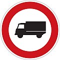
B04cr.jpg|B 4: No lorries |
|||
B05cr.jpg|B 5: No buses |
|||
B06cr.jpg|B 6: No tractors |
|||
B07cr.jpg|B 7: No motorcycles |
|||
B08cr.jpg|B 8: No cycles |
|||
B09cr.jpg|B 9: No animal-drawn vehicles |
|||
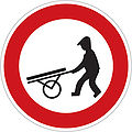
B10cr.jpg|B 10: No handcart |
|||
B11cr.jpg|B 11: No motor vehicles |
|||
B12cr.jpg|B 12: No entry to the vehicles indicated |
|||
B13cr.jpg|B 13: No vehicles heavier than indicated |
|||
B14cr.jpg|B 14: No vehicles with axle weight greater than indicated |
|||
B15cr.jpg|B 15: No vehicles wider than indicated |
|||
B16cr.jpg|B 16: No vehicles taller than indicated |
|||
B17cr.jpg|B 17: No vehicles or combinations longer than indicated |
|||
B18cr.jpg|B 18: No vehicles carrying hazardous cargo |
|||
B19cr.jpg|B 19: No vehicles carrying cargo that may cause water pollution |
|||
B20acr.jpg|B 20a: Speed limit |
|||
B20bcr.jpg|B 20b: End of speed limit |
|||
B21a.svg|B 21a: No overtaking |
|||
B21bcr.jpg|B 21b: End of no-overtaking zone |
|||
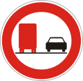
B22a.svg|B 22a: No overtaking by lorries |
|||
B22bcr.jpg|B 22b: End of no-overtaking zone for lorries |
|||
B23acr.jpg|B 23a: No use of audible warning signals |
|||
B23bcr.jpg|B 23b: End of no audible warnings zone |
|||
B24acz.jpg|B 24a: No right turn |
|||
B24bcz.jpg|B 24b: No left turn |
|||
B25cr.jpg|B 25: No [[turning in the road]] |
|||
CZ road sign B-26.svg|B 26: End of all prohibitions |
|||
Czech Republic road sign B 27.svg|B 27: Obligation to stop (traffic control) |
|||
Image:B27cr.jpg|Stop — check point (e.g. police check, e.g. customs) |
|||
CZ road sign B-28.svg|B 28: No stopping and no parking |
|||
CZ road sign B-29.svg|B 29: No parking |
|||
B30cr.jpg|B 30: No pedestrians |
|||
CZ-B30a Zákaz vjezdu osob na osobních přepravnících (2016).jpg|B 30a: No entry to persons on personal transporters |
|||
Image:B31cr.jpg|No animal riders |
|||
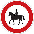
B31cr.jpg|B 31: No animal riders |
|||
Image:B32cr.jpg|Worded prohibition ([[smog]]) |
|||
Czech_Republic_road_sign_B_32.svg|B 32: Other prohibition (Driving through forbidden) |
|||
Image:B33cr.jpg|No vehicles towing trailers |
|||
B33cr.jpg|B 33: No vehicles towing trailers |
|||
B34cr.jpg|B 34: Minimum distance between vehicles |
|||
</gallery> |
</gallery> |
||
==Mandatory signs== |
==Mandatory signs== |
||
<gallery> |
<gallery> |
||
File:CZ road sign C01.svg|C 1: Roundabout |
|||
File:CZ road sign C02a.svg|C 2a: Proceed straight |
|||
Image:C02acr.jpg|Ahead only |
|||
File:CZ road sign C02b.svg|C 2b: Turn right ahead |
|||
File:CZ road sign C02c.svg|C 2c: Turn left ahead |
|||
File:CZ road sign C02d.svg|C 2d: Proceed straight or right only |
|||
File:CZ road sign C02e.svg|C 2e: Proceed straight or left only |
|||
File:CZ road sign C02f.svg|C 2f: Turn left or right only |
|||
File:CZ road sign C03a.svg|C 3a: Turn right here |
|||
File:CZ road sign C03b.svg|C 3b: Turn left here |
|||
File:CZ road sign C04a.svg|C 4a: Pass on right |
|||
Image:C04acr.jpg|Keep right |
|||
File:CZ road sign C04b.svg|C 4b: Pass on left |
|||
Image:C04bcr.jpg|Keep left |
|||
File:CZ road sign C04c.svg|C 4c: Pass on left or right |
|||
Image:C04ccr.jpg|Traffic may pass either side to reach same destination |
|||
File:CZ road sign C05a.svg|C 5a: [[Snow chains]] compulsory |
|||
File:CZ road sign C05b.svg|C 5b: End of compulsory snow chains zone |
|||
File:CZ road sign C06a.30.svg|C 6a: Minimum speed limit |
|||
File:CZ road sign C06b.30.svg|C 6b: End of minimum speed limit |
|||
File:CZ road sign C-7a.svg|C 7a: Pedestrian path |
|||
File:CZ road sign C-7b.svg|C 7b: End of pedestrian path |
|||
File:Cyklostezka bicycle road sign.svg|C 8a: [[Cycleway]] |
|||
Image:C08acr.jpg|Cycleway |
|||
File:CZ road sign C08b.svg|C 8b: End of cycleway |
|||
File:CZ road sign C09a.svg|C 9a: [[Shared-use path|Shared pedestrian and cycle path]] |
|||
File:CZ road sign C09b.svg|C 9b: End of shared pedestrian and cycle path |
|||
File:CZ road sign C10a.svg|C 10a: Separated pedestrian and cycle path |
|||
File:C10bcr.jpg|C 10b: End of separated pedestrian and cycle path |
|||
File:CZ road sign C11a.svg|C 11a: [[Bridle path]] |
|||
Image:C11acr.jpg|Route for animal riders ([[bridleway]]) |
|||
File:CZ road sign C11b.svg|C 11b: End of bridle path |
|||
Image:C11bcr.jpg|End of route for animal riders |
|||
File:CZ road sign C12a.svg|C 12a: Indicated vehicles may use only this lane |
|||
File:CZ road sign C12b.svg|C 12b: Indicated vehicles may use only this lane – end |
|||
File:CZ road sign C13a.svg|C 13a: Use headlights |
|||
File:CZ road sign C13b.svg|C 13b: Use headlights – end of zone |
|||
File:CZ road sign C14a.svg|C 14a: Other command |
|||
Image:C14acr.jpg|Worded order (Cyclists dismount) |
|||
File:CZ road sign C14b.svg|C 14b: End of other command |
|||
Image:C14bcr.jpg|End of zone given by worded order |
|||
File:CZ road sign C-15a.svg|C 15a: Winter equipment |
|||
Image:CZ-C15a Zimní výbava.gif|Compulsory winter tires |
|||
File:CZ road sign C-15b.svg|C 15b: Winter equipment – end |
|||
Image:CZ-C15b Zimní výbava - konec.gif|End of compulsory winter tires zone |
|||
</gallery> |
</gallery> |
||
==Direction, position or indication signs== |
==Direction, position or indication signs== |
||
<gallery> |
<gallery> |
||
File:IS01acr.jpg|Route indicator with direction via expressway-ring road (single destination) (old) |
|||
File:IS01bcr.jpg|Route indicator with direction via expressway-ring road (two destinations) (old) |
|||
File:IS01ccr.jpg|Route indicator with direction via expressway (single destination) (old) |
|||
File:IS01dcr.jpg|Route indicator with direction via expressway (two destinations) (old) |
|||
File:IS02acr.jpg|Route indicator with direction via road for motor vehicles |
|||
File:IS02bcr.jpg|Route indicator with direction via road for motor vehicles (two destination) (old) |
|||
File:IS02ccr.jpg|Route indicator with direction via road for motor vehicles (single destination) (old) |
|||
File:IS02dcr.jpg|Route indicator with direction via road for motor vehicles s (two destinations) (old) |
|||
File:IS03acr.jpg|Route indicator (single destination) |
|||
File:IS03bcr.jpg|Route indicator (two destinations) |
|||
File:IS03ccr.jpg|Route indicator (single destination) |
|||
File:IS03dcr.jpg|Route indicator (two destinations) |
|||
File:IS04acr.jpg|Local route indicator (single destination) |
|||
File:IS04bcr.jpg|Local route indicator (two destinations) |
|||
File:IS04ccr.jpg|Local route indicator (single destination) |
|||
File:IS04dcr.jpg|Local route indicator (two destinations) |
|||
File:IS05cr.jpg|Route indicator to specific destination (airport) |
|||
File:IS09acr.jpg|Advance sign for junction |
|||
File:IS9b.svg|Advance sign for roundabout |
|||
File:IS09ccr.jpg|Advance sign for restriction |
|||
File:IS09dcr.jpg|Route indicator avoiding restriction |
|||
File:IS09ecr.jpg|Route indicator avoiding restricted turn |
|||
File:IS10a.svg|Signboard – change of driving direction |
|||
File:IS10b.svg|Signboard – change of driving direction |
|||
File:IS10c.svg|Signboard – change direction |
|||
File:IS10e.svg|Signboard – change of driving direction with indicated restriction |
|||
File:IS11a.svg|Advance sign for route avoiding restriction |
|||
File:IS11bcr.jpg|Diverted traffic for indicated destination |
|||
File:IS11ccr.jpg|Diverted traffic |
|||
File:IS11dcr.jpg|Diverted traffic for indicated route |
|||
File:IS12acr.jpg|Community (speed limit 50 km/h implied) |
|||
File:IS12bcr.jpg|End of Community (speed limit 90 km/h implied) |
|||
File:IS13cr.jpg|Route confirmation near destination |
|||
File:IS14cr.jpg|Regional border |
|||
File:IS15acr.jpg|Worded sign (name of a river the road crosses) |
|||
File:IS15bcr.jpg|Worded sign (name of a tunnel, length 2000 m) |
|||
File:CZ traffic sign IS16a - D5.svg|Highway (D5) |
|||
File:CZ traffic sign IS16a - D46.svg|Highway (D46) |
|||
Image:IS16bcr.jpg|I. class road (4) |
|||
File:SilniceI4.svg|I class road (or expressway while marked) |
|||
File:SilniceI57.svg|I class road (or expressway while marked) |
|||
Image:CZ traffic sign IS17 - E50.svg|[[International_E-road_network|E-road]] indicator |
|||
File:SilniceII302.svg|II class road |
|||
Image:IS18acr.jpg|[[milestone]] ("kilometrestone") |
|||
File:CZ traffic sign IS17 - E50.svg|[[International E-road network|E-road]] indicator |
|||
Image:IS18bcr.jpg|[[milestone]] ("kilometrestone") |
|||
File:IS18acr.jpg|[[milestone]] ("kilometrestone") |
|||
Image:IS19bcr.jpg|Route indicator for cyclists (two destinations) |
|||
File:IS18bcr.jpg|[[milestone]] ("kilometrestone"); nearest [[emergency phone]] ahead |
|||
Image:IS19ccr.jpg|Route indicator for cyclists (single destination) |
|||
File:IS19bcr.jpg|Route indicator for cycles (two destinations) |
|||
File:IS19ccr.jpg|Route indicator for cycles (single destination) |
|||
File:IS19dcr.jpg|Route indicator for cycles (two destinations) |
|||
Image:IS21acr.jpg|Cycle route (16) |
|||
File:IS20cr.jpg|Advance sign for crossing for cycles |
|||
Image:IS21bcr.jpg|Cycle route (3) |
|||
File:IS21acr.jpg|Cycle route (16) |
|||
Image:IS22bcr.jpg|Street name |
|||
File:IS21bcr.jpg|Cycle route (3) |
|||
Image:IS23cr.jpg|Cultural or tourist destination |
|||
File:IS22bcr.jpg|Street name |
|||
Image:IS24acr.jpg|Direction to cultural or tourist destination |
|||
File:IS23cr.jpg|Cultural or tourist destination |
|||
File:IS24acr.jpg|Direction to cultural or tourist destination |
|||
File:IS24b.jpg|Distance and direction to cultural or tourist destination |
|||
</gallery> |
</gallery> |
||
==Informational, facilities or service signs== |
==Informational, facilities or service signs maker signs, etc.== |
||
<gallery> |
<gallery> |
||
File:CZ traffic sign IP1a.svg|[[Ring road|Circular route]] <br> (formerly used [[File:CZ-IP01a Okruh.svg|30px]]) |
|||
File:CZ traffic sign IP1b.svg|Turn to follow circular route <br> (formerly used [[File:IP01bcr.jpg|30px]]) |
|||
File:IP2-INFZN.svg|Speed bumps |
|||
File:IP3-INFZN.svg|Underpass or elevated walkway |
|||
File:IP4a-INFZN.svg|One-way traffic |
|||
File:CZ road sign IP-4b.svg|One-way street |
|||
File:CZ road sign IP-5 (70).svg|Recommended speed (70 km/h) |
|||
File:CZ road sign IP-6.svg|Pedestrian crossing |
|||
File:CZ road sign IP-7.svg|Cycle crossing |
|||
File:IP8a-INFZN.svg|Tunnel |
|||
File:IP8b-INFZN.svg|End of tunnel |
|||
File:IP9-INFZN.svg|Emergency parking |
|||
File:CZ road sign IP-10a.svg|No through road (dead end) |
|||
File:CZ-IP11a Parkoviště.svg|Parking |
|||
File:IP11bcr.jpg|Parking (at right angles or diagonal to traffic) |
|||
File:IP11ccr.jpg|Parking (in line with traffic) |
|||
File:IP11dcr.jpg|Parking on the pavement (at right angles or diagonal to traffic) |
|||
File:IP11ecr.jpg|Parking on the pavement (in line with traffic) |
|||
File:IP11fcr.jpg|Parking partly on the pavement (at right angles or diagonal to traffic) |
|||
File:IP11gcr.jpg|Parking partly on the pavement (in line with traffic) |
|||
File:IP12cr.jpg|Reserved parking |
|||
File:IP13acr.jpg|Covered parking |
|||
File:IP13bcr.jpg|Parking with permit (disc) |
|||
File:IP13ccr.jpg|Metered parking |
|||
File:IP13dcr.jpg|[[Park and ride]] |
|||
File:CZ traffic sign IZ1a.svg|Expressway (speed limit 130 km/h implied, 80 km/h in city) |
|||
File:CZ traffic sign IZ1b.svg|End of expressway (speed limit 90 km/h implied) |
|||
File:CZ traffic sign IZ2a.svg|Road for motor vehicles (speed limit 110 km/h implied, 80 km/h in city) |
|||
File:CZ traffic sign IZ2b.svg|End of road for motor vehicles (speed limit 90 km/h implied) |
|||
File:IP16.svg|Lane arrangement |
|||
File:IP17.svg|Lane arrangement |
|||
File:IP18a.svg|Number of lanes increases |
|||
File:IP18b.svg|Number of lanes decreases |
|||
File:IP18ccr.jpg|[[Crawler lane]] |
|||
File:IP19.svg|Lanes diverge |
|||
File:IP20a.svg|Bus lane |
|||
File:IP20b.svg|End of bus lane |
|||
File:IP21a.svg|Restrictions in lane |
|||
File:IP22.svg|Caution, change of arrangement (end of priority way) |
|||
File:IP23a.svg|Drive left around tram |
|||
File:IP23b.svg|Drive left alongside tramway |
|||
File:Czech Republic road sign IP 24.svg|[[Escape lane]] (in case of brake failure) |
|||
File:IP25a.svg|Zone having the restriction indicated |
|||
File:IP25b.svg|End of zone having the restriction indicated |
|||
File:IP26a.svg|Residential area (speed limit 20 km/h implied) |
|||
File:IP26b.svg|End of residential area (end of speed limit 20 km/h implied) |
|||
File:IP27a.svg|Pedestrian zone (supply may enter in indicated times) |
|||
File:IP27b.svg|End of pedestrian zone |
|||
File:Czech-traffic-signs-eu-cz.svg|Border crossing |
|||
Image:IP28cr.jpg|Maximum speed limits |
|||
File:CZ-IP28b Nejvyšší dovolené rychlosti (2016 - verze 2015-07-31).jpg|Maximum speed limits (passenger cars only) |
|||
Image:IP29cr.jpg|Merge in turn |
|||
File:IP29.svg|Merge in turn |
|||
Image:IJ01cr.jpg|Police |
|||
File:IJ01cr.jpg|Police |
|||
File:IJ02cr.jpg|Hospital |
|||
Image:IJ03cr.jpg|[[First aid]] |
|||
File:CZ road sign IJ-3.svg|[[First aid]] |
|||
Image:IJ04acr.jpg|A (bus, tram, trolleybus) stop |
|||
File:CZ road sign IJ-4a.svg|A (bus, tram, trolleybus) stop |
|||
File:CZ road sign IJ-4b.svg|A bus stop |
|||
File:IJ04ccr.jpg|Bus stop |
|||
File:IJ04dcr.jpg|Tram stop |
|||
File:IJ04ecr.jpg|Trolleybus stop |
|||
Image:IJ05cr.jpg|Information |
|||
File:CZ road sign IJ-5.svg|Information |
|||
Image:IJ06cz.jpg|Telephone |
|||
File:IJ06cz.jpg|Telephone |
|||
Image:IJ07cr.jpg|Filling station |
|||
File:IJ07cr.jpg|Filling station |
|||
File:IJ08cr.jpg|Repair shop |
|||
Image:IJ09cr.jpg|Vehicle testing centre |
|||
File:IJ09cr.jpg|Vehicle inspection station |
|||
Image:IJ10cr.jpg|Hotel or motel |
|||
File:IJ10cr.jpg|Hotel or motel |
|||
Image:IJ11acr.jpg|Restaurant |
|||
File:CZ-IJ11a Restaurace.svg|Eatery |
|||
Image:IJ11bcr.jpg|Refreshments |
|||
File:IJ11bcr.jpg|Café |
|||
File:IJ12cr.jpg|Restroom |
|||
File:IJ13cr.jpg|Rest stop |
|||
File:IJ14acr.jpg|Camp site |
|||
File:IJ14bcr.jpg|Caravan site |
|||
File:IJ14ccr.jpg|Caravan and camp site |
|||
Image:IJ15cr.jpg|Traffic broadcast |
|||
File:IJ15cr.jpg|Radio station |
|||
</gallery> |
</gallery> |
||
{{Traffic signs}} |
{{Traffic signs}} |
||
{{Europe topic|Road signs in}} |
|||
==References== |
|||
{{Reflist}} |
|||
[[Category:Road signs by country|Czech Republic]] |
[[Category:Road signs by country|Czech Republic]] |
||
Latest revision as of 08:46, 6 December 2024

Road signs in the Czech Republic (Czechia) are regulated by the Ministry of Transport and the police. The signs are nearly the same as the European norm, but with small changes (e.g., the text is in Czech, some differences in colour). The law governing the road signs is Decree number 30/2001 Sb., many times amended, and replaced by decree 294/2015 Sb., in force since 1 January 2016.
Czech road signs depict people with realistic (as opposed to stylized) silhouettes.
Czechoslovakia had originally signed the Vienna Convention on Road Signs and Signals on November 8, 1968, and ratified it on June 7, 1978.[1] After the dissolution of Czechoslovakia, which took effect on December 31, 1992, both the Czech Republic and Slovakia succeeded to the Vienna Convention on June 2, 1993, and on May 28, 1993, respectively.
Dimensions (mm)
[edit]| Size | Triangle | Circle | Square | Rectangle | Octagon |
|---|---|---|---|---|---|
| small | 700 | 500 | 400 | — | — |
| normal | 900 | 700 | 500 | 500 × 700 | 700 |
| large | 1250 | 900 | 750 | 1000 × 1400 or 1000 × 1500 | 900 |
Warning signs
[edit]-
A 1a: Sharp curve to the right
-
A 1b: Sharp curve to the left
-
A 2a: Double curve, first to the right
-
A 2b: Double curve, first to the left
-
A 3: Intersection
-
A 4: Intersection with a roundabout
-
A 5a: Steep descent
-
A 5b: Steep ascent
-
A 6a: Road narrows from both sides
-
A 6b: Road narrows from the right side
-
A 7a: Uneven road
-
A 7b: Speed bumps
-
A 8: Slippery road
-
A 9: Two-way traffic
-
A 10: Traffic semaphore
-
A 11: Pedestrian crossing
-
A 12a: Pedestrians
-
A 12b: Children
-
A 12c: Persons on personal transporters
-
A 13: Farm animals (cow)
-
A 14: Wild animals (deer)
-
A 15: Roadworks
-
A 16: Side winds
-
A 17: Loose chippings
-
A 18: Falling rocks
-
A 19: Cyclists
-
A 20: Aircraft activity
-
A 21: Tunnel
-
A 22: Other danger
-
A 23: Queue
-
A 24: Slippery ice
-
A 25: Tramway
-
A 26: Fog
-
A 27: Accident
-
A 28: Soft verge
-
A 29: Level crossing with gates or barriers
-
A 30: Level crossing without gates or barriers
-
A 31a: Distance marker (240 m)
-
A 31b: Distance marker (160 m)
-
A 31c: Distance marker (80 m)
-
A 32a: Warning cross for single-track railway crossing
-
A 32b: Warning cross, multiple-track railway crossing
-
A 33: Opening or swing bridge
-
A 34: Quayside or riverbank ahead
Priority signs
[edit]-
P 1: Junction with minor roads
-
P 2: Priority road/crossroad
-
P 3: End of priority road/crossroad
-
P 4: Yield
-
P 5: Yield to trams
-
P 6: Stop and give way
-
P 7: Oncoming traffic have priority
-
P 8: Priority over oncoming traffic
Prohibitive or restrictive signs
[edit]-
B 1: No entry for vehicles (both directions)
-
B 2: No entry for vehicles
-
B 3a: No entry for motor vehicles, except motorcycles
-
B 3b: No cars
-
B 4: No lorries
-
B 5: No buses
-
B 6: No tractors
-
B 7: No motorcycles
-
B 8: No cycles
-
B 9: No animal-drawn vehicles
-
B 10: No handcart
-
B 11: No motor vehicles
-
B 12: No entry to the vehicles indicated
-
B 13: No vehicles heavier than indicated
-
B 14: No vehicles with axle weight greater than indicated
-
B 15: No vehicles wider than indicated
-
B 16: No vehicles taller than indicated
-
B 17: No vehicles or combinations longer than indicated
-
B 18: No vehicles carrying hazardous cargo
-
B 19: No vehicles carrying cargo that may cause water pollution
-
B 20a: Speed limit
-
B 20b: End of speed limit
-
B 21a: No overtaking
-
B 21b: End of no-overtaking zone
-
B 22a: No overtaking by lorries
-
B 22b: End of no-overtaking zone for lorries
-
B 23a: No use of audible warning signals
-
B 23b: End of no audible warnings zone
-
B 24a: No right turn
-
B 24b: No left turn
-
B 25: No turning in the road
-
B 26: End of all prohibitions
-
B 27: Obligation to stop (traffic control)
-
B 28: No stopping and no parking
-
B 29: No parking
-
B 30: No pedestrians
-
B 30a: No entry to persons on personal transporters
-
B 31: No animal riders
-
B 32: Other prohibition (Driving through forbidden)
-
B 33: No vehicles towing trailers
-
B 34: Minimum distance between vehicles
Mandatory signs
[edit]-
C 1: Roundabout
-
C 2a: Proceed straight
-
C 2b: Turn right ahead
-
C 2c: Turn left ahead
-
C 2d: Proceed straight or right only
-
C 2e: Proceed straight or left only
-
C 2f: Turn left or right only
-
C 3a: Turn right here
-
C 3b: Turn left here
-
C 4a: Pass on right
-
C 4b: Pass on left
-
C 4c: Pass on left or right
-
C 5a: Snow chains compulsory
-
C 5b: End of compulsory snow chains zone
-
C 6a: Minimum speed limit
-
C 6b: End of minimum speed limit
-
C 7a: Pedestrian path
-
C 7b: End of pedestrian path
-
C 8a: Cycleway
-
C 8b: End of cycleway
-
C 9b: End of shared pedestrian and cycle path
-
C 10a: Separated pedestrian and cycle path
-
C 10b: End of separated pedestrian and cycle path
-
C 11a: Bridle path
-
C 11b: End of bridle path
-
C 12a: Indicated vehicles may use only this lane
-
C 12b: Indicated vehicles may use only this lane – end
-
C 13a: Use headlights
-
C 13b: Use headlights – end of zone
-
C 14a: Other command
-
C 14b: End of other command
-
C 15a: Winter equipment
-
C 15b: Winter equipment – end
Direction, position or indication signs
[edit]-
Route indicator with direction via expressway-ring road (single destination) (old)
-
Route indicator with direction via expressway-ring road (two destinations) (old)
-
Route indicator with direction via expressway (single destination) (old)
-
Route indicator with direction via expressway (two destinations) (old)
-
Route indicator with direction via road for motor vehicles
-
Route indicator with direction via road for motor vehicles (two destination) (old)
-
Route indicator with direction via road for motor vehicles (single destination) (old)
-
Route indicator with direction via road for motor vehicles s (two destinations) (old)
-
Route indicator (single destination)
-
Route indicator (two destinations)
-
Route indicator (single destination)
-
Route indicator (two destinations)
-
Local route indicator (single destination)
-
Local route indicator (two destinations)
-
Local route indicator (single destination)
-
Local route indicator (two destinations)
-
Route indicator to specific destination (airport)
-
Advance sign for junction
-
Advance sign for roundabout
-
Advance sign for restriction
-
Route indicator avoiding restriction
-
Route indicator avoiding restricted turn
-
Signboard – change of driving direction
-
Signboard – change of driving direction
-
Signboard – change direction
-
Signboard – change of driving direction with indicated restriction
-
Advance sign for route avoiding restriction
-
Diverted traffic for indicated destination
-
Diverted traffic
-
Diverted traffic for indicated route
-
Community (speed limit 50 km/h implied)
-
End of Community (speed limit 90 km/h implied)
-
Route confirmation near destination
-
Regional border
-
Worded sign (name of a river the road crosses)
-
Worded sign (name of a tunnel, length 2000 m)
-
Highway (D5)
-
Highway (D46)
-
I class road (or expressway while marked)
-
I class road (or expressway while marked)
-
II class road
-
E-road indicator
-
milestone ("kilometrestone")
-
milestone ("kilometrestone"); nearest emergency phone ahead
-
Route indicator for cycles (two destinations)
-
Route indicator for cycles (single destination)
-
Route indicator for cycles (two destinations)
-
Advance sign for crossing for cycles
-
Cycle route (16)
-
Cycle route (3)
-
Street name
-
Cultural or tourist destination
-
Direction to cultural or tourist destination
-
Distance and direction to cultural or tourist destination
Informational, facilities or service signs maker signs, etc.
[edit]-
Speed bumps
-
Underpass or elevated walkway
-
One-way traffic
-
One-way street
-
Recommended speed (70 km/h)
-
Pedestrian crossing
-
Cycle crossing
-
Tunnel
-
End of tunnel
-
Emergency parking
-
No through road (dead end)
-
Parking
-
Parking (at right angles or diagonal to traffic)
-
Parking (in line with traffic)
-
Parking on the pavement (at right angles or diagonal to traffic)
-
Parking on the pavement (in line with traffic)
-
Parking partly on the pavement (at right angles or diagonal to traffic)
-
Parking partly on the pavement (in line with traffic)
-
Reserved parking
-
Covered parking
-
Parking with permit (disc)
-
Metered parking
-
Expressway (speed limit 130 km/h implied, 80 km/h in city)
-
End of expressway (speed limit 90 km/h implied)
-
Road for motor vehicles (speed limit 110 km/h implied, 80 km/h in city)
-
End of road for motor vehicles (speed limit 90 km/h implied)
-
Lane arrangement
-
Lane arrangement
-
Number of lanes increases
-
Number of lanes decreases
-
Lanes diverge
-
Bus lane
-
End of bus lane
-
Restrictions in lane
-
Caution, change of arrangement (end of priority way)
-
Drive left around tram
-
Drive left alongside tramway
-
Escape lane (in case of brake failure)
-
Zone having the restriction indicated
-
End of zone having the restriction indicated
-
Residential area (speed limit 20 km/h implied)
-
End of residential area (end of speed limit 20 km/h implied)
-
Pedestrian zone (supply may enter in indicated times)
-
End of pedestrian zone
-
Border crossing
-
Maximum speed limits (passenger cars only)
-
Merge in turn
-
Police
-
Hospital
-
A (bus, tram, trolleybus) stop
-
A bus stop
-
Bus stop
-
Tram stop
-
Trolleybus stop
-
Information
-
Telephone
-
Filling station
-
Repair shop
-
Vehicle inspection station
-
Hotel or motel
-
Eatery
-
Café
-
Restroom
-
Rest stop
-
Camp site
-
Caravan site
-
Caravan and camp site
-
Radio station
References
[edit]- ^ "United Nations Treaty Collection". treaties.un.org. Retrieved 2023-12-07.


