Trzemeszno Lubuskie: Difference between revisions
Micga~enwiki (talk | contribs) mNo edit summary |
m Format administrative division links, remove DEFAULTSORTKEY as per WP:SORTKEY, remove One Source for stubs, minor formatting changes (AWB) |
||
| (10 intermediate revisions by 8 users not shown) | |||
| Line 3: | Line 3: | ||
| settlement_type = Village |
| settlement_type = Village |
||
| total_type = |
| total_type = |
||
| image_skyline = |
| image_skyline = Trzemeszno Lubuskie - kosciol.JPG |
||
| image_caption = |
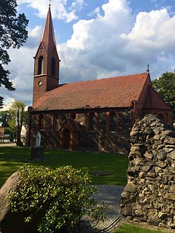
| image_caption = Catholic church (formerly Protestant) |
||
| image_flag = |
| image_flag = |
||
| image_shield = |
| image_shield = |
||
| image_map = |
| image_map = |
||
| ⚫ | |||
| coordinates_region = PL |
|||
| ⚫ | |||
| ⚫ | |||
| ⚫ | |||
| subdivision_type1 = [[Voivodeships of Poland|Voivodeship]] |
| subdivision_type1 = [[Voivodeships of Poland|Voivodeship]] |
||
| subdivision_name1 = [[Lubusz Voivodeship|Lubusz]] |
| subdivision_name1 = [[Lubusz Voivodeship|Lubusz]] |
||
| Line 17: | Line 16: | ||
| subdivision_type3 = [[Gmina]] |
| subdivision_type3 = [[Gmina]] |
||
| subdivision_name3 = [[Gmina Sulęcin|Sulęcin]] |
| subdivision_name3 = [[Gmina Sulęcin|Sulęcin]] |
||
| ⚫ | |||
| latd = 52 |
|||
| latm = 26 |
|||
| lats = |
|||
| latNS = N |
|||
| longd = 15 |
|||
| longm = 15 |
|||
| longs = |
|||
| longEW = E |
|||
| pushpin_map = Poland |
| pushpin_map = Poland |
||
| pushpin_label_position = right |
| pushpin_label_position = right |
||
| elevation_m = |
| elevation_m = |
||
| population_total = 700 |
| population_total = 700 |
||
| website = http://www.trzemesznolubuskie.vgh.pl }} |
| website = http://www.trzemesznolubuskie.vgh.pl |
||
}} |
|||
'''Trzemeszno Lubuskie''' {{IPAc-pl|t|sz|e|'|m|e|sz|n|o|-|l|u|'|b|u|s|k|J|e}} is a [[village]] in the administrative district of [[Gmina Sulęcin]], within [[Sulęcin County]], [[Lubusz Voivodeship]], in western Poland.<ref name="TERYT">{{cite web |url=http://www.stat.gov.pl/broker/access/prefile/listPreFiles.jspa |title=Central Statistical Office (GUS) |
'''Trzemeszno Lubuskie''' {{IPAc-pl|t|sz|e|'|m|e|sz|n|o|-|l|u|'|b|u|s|k|J|e}} is a [[village]] in the administrative district of [[Gmina Sulęcin]], within [[Sulęcin County]], [[Lubusz Voivodeship]], in western [[Poland]].<ref name="TERYT">{{cite web |url=http://www.stat.gov.pl/broker/access/prefile/listPreFiles.jspa |title=Central Statistical Office (GUS) – TERYT (National Register of Territorial Land Apportionment Journal) |date=2008-06-01 |language=Polish}}</ref> It lies approximately {{convert|10|km|mi|0}} east of [[Sulęcin]], {{convert|34|km|mi|0|abbr=on}} south of [[Gorzów Wielkopolski]], and {{convert|58|km|mi|0|abbr=on}} north of [[Zielona Góra]]. |
||
== History == |
|||
In the course of the [[Second Partition of Poland]] in 1793, |
In the course of the [[Second Partition of Poland]] in 1793, the village, under the [[Germanisation|Germanized]] name of Schermeisel, was annexed by the [[Kingdom of Prussia]] and from 1815 incorporated into the [[Grand Duchy of Posen]]. In 1816, after a border adjustment, it became part of the Prussian [[Province of Brandenburg]]. From 1871 to 1945, Schermeisel belonged to [[German Reich|Germany]]. After [[World War II]], with the implementation of the [[Oder-Neisse line]] the village was returned to Poland. |
||
| ⚫ | |||
The village has a population of 700. |
|||
| ⚫ | |||
== External links == |
== External links == |
||
{{commons category|Trzemeszno Lubuskie}} |
|||
* [http://www.sztetl.org.pl/en/city/trzemeszno-lubuskie/ Jewish Community in Trzemeszno Lubuskie] on Virtual Shtetl |
* [http://www.sztetl.org.pl/en/city/trzemeszno-lubuskie/ Jewish Community in Trzemeszno Lubuskie] on Virtual Shtetl |
||
| ⚫ | |||
| ⚫ | |||
<br> |
|||
{{Gmina Sulęcin}} |
{{Gmina Sulęcin}} |
||
| ⚫ | |||
| ⚫ | |||
[[Category:Villages in Sulęcin County |
[[Category:Villages in Sulęcin County]] |
||
| ⚫ | |||
Latest revision as of 07:42, 10 October 2024
Trzemeszno Lubuskie | |
|---|---|
Village | |
 Catholic church (formerly Protestant) | |
| Coordinates: 52°26′N 15°15′E / 52.433°N 15.250°E | |
| Country | |
| Voivodeship | Lubusz |
| County | Sulęcin |
| Gmina | Sulęcin |
| Population | 700 |
| Website | http://www.trzemesznolubuskie.vgh.pl |
Trzemeszno Lubuskie [tʂɛˈmɛʂnɔ luˈbuskʲɛ] is a village in the administrative district of Gmina Sulęcin, within Sulęcin County, Lubusz Voivodeship, in western Poland.[1] It lies approximately 10 kilometres (6 mi) east of Sulęcin, 34 km (21 mi) south of Gorzów Wielkopolski, and 58 km (36 mi) north of Zielona Góra.
History
[edit]In the course of the Second Partition of Poland in 1793, the village, under the Germanized name of Schermeisel, was annexed by the Kingdom of Prussia and from 1815 incorporated into the Grand Duchy of Posen. In 1816, after a border adjustment, it became part of the Prussian Province of Brandenburg. From 1871 to 1945, Schermeisel belonged to Germany. After World War II, with the implementation of the Oder-Neisse line the village was returned to Poland.
References
[edit]External links
[edit]- Jewish Community in Trzemeszno Lubuskie on Virtual Shtetl


