Georgepeta: Difference between revisions
Appearance
Content deleted Content added
Phanisaladi (talk | contribs) No edit summary Tags: Mobile edit Mobile app edit |
Path slopu (talk | contribs) →top: Added navbox {{East Godavari district}} |
||
| (31 intermediate revisions by 13 users not shown) | |||
| Line 1: | Line 1: | ||
{{unreferenced|date=October 2018}} |
|||
{{Use dmy dates|date=October 2018}} |
|||
{{Use Indian English|date=October 2018}} |
|||
{{Infobox settlement |
{{Infobox settlement |
||
| name = Georgepeta |
| name = Georgepeta |
||
| native_name = |
| native_name = |
||
| native_name_lang = |
| native_name_lang = |
||
| other_name = |
| other_name = |
||
| nickname = |
| nickname = |
||
| settlement_type = |
| settlement_type = [[Village]] |
||
| image_skyline |
| image_skyline = File:Georgepeta sign board.jpg |
||
= |
|||
| image_alt = |
| image_alt = |
||
| image_caption = |
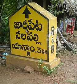
| image_caption = A R&B Sign board indicating Yanam, Nelapalli and Georgepeta Villages near Y-Junction |
||
| pushpin_map = |
| pushpin_map = India Andhra Pradesh#India |
||
| pushpin_label_position = right |
| pushpin_label_position = right |
||
| pushpin_map_alt = |
| pushpin_map_alt = |
||
| pushpin_map_caption = Location in Andhra Pradesh, India |
| pushpin_map_caption = Location in Andhra Pradesh, India |
||
| |
| coordinates = {{coord|16.743551|N|82.224371|E|display=inline,title}} |
||
| ⚫ | |||
| lats = |
|||
| latNS = N |
|||
| ⚫ | |||
| longm = |
|||
| longs = |
|||
| longEW = E |
|||
| coordinates_display = inline,title |
|||
| subdivision_type = Country |
| subdivision_type = Country |
||
| subdivision_name = |
| subdivision_name = [[India]] |
||
| subdivision_type1 = [[States and territories of India|State]] |
| subdivision_type1 = [[States and territories of India|State]] |
||
| subdivision_name1 = [[Andhra Pradesh]] |
| subdivision_name1 = [[Andhra Pradesh]] |
||
| subdivision_type2 = [[List of districts of India|District]] |
| subdivision_type2 = [[List of districts of India|District]] |
||
| subdivision_name2 = East Godavari |
| subdivision_name2 = [[East Godavari district|East Godavari]] |
||
| established_title = <!-- Established --> |
| established_title = <!-- Established --> |
||
| established_date = |
| established_date = |
||
| Line 41: | Line 35: | ||
| elevation_footnotes = |
| elevation_footnotes = |
||
| elevation_m = |
| elevation_m = |
||
| population_total = |
| population_total = |
||
| population_as_of = |
| population_as_of = |
||
| population_rank = |
| population_rank = |
||
| Line 57: | Line 51: | ||
| area_code = 0884 |
| area_code = 0884 |
||
| registration_plate = AP 05 |
| registration_plate = AP 05 |
||
| blank1_name_sec1 = Nearest city |
|||
| blank1_info_sec1 = Yanam |
|||
| blank2_name_sec1 = [[Lok Sabha]] constituency |
| blank2_name_sec1 = [[Lok Sabha]] constituency |
||
| blank2_info_sec1 = Amalapuram |
| blank2_info_sec1 = Amalapuram |
||
| blank3_name_sec1 = [[Vidhan Sabha]] constituency |
| blank3_name_sec1 = [[Vidhan Sabha]] constituency |
||
| blank3_info_sec1 = Mummidivaram |
| blank3_info_sec1 = Mummidivaram |
||
| |
| website = |
||
| blank1_info_sec2 = [[Climatic regions of India|hot]] <small>([[Köppen climate classification|Köppen]])</small> |
|||
| website = {{URL|www.georgepeta.blogspot.com}} |
|||
| footnotes = |
| footnotes = |
||
| image_map = {{infobox mapframe|zoom=14}} |
|||
| ⚫ | |||
| ⚫ | |||
}} |
}} |
||
'''Georgepeta''' is the major panchayath village in [[Thallarevu]] mandal in [[East Godavari district]], [[Andhra Pradesh]] |
'''Georgepeta''' is the major panchayath village in [[Thallarevu]] mandal in [[East Godavari district]], [[Andhra Pradesh]]. |
||
The Georgepeta revenue previously part in [[Neelapalle]] Panchayath and it was separated from Neelapalli revenue in the year 1972. In olden days, this town was used for storing [[tobacco]] by the British people. Every year people of this village celebrate Mukkoti Ekadasi and nellapalli amma thertham at the year ends and the first ever lord sri rama idols from bhadrachalam landed in town and The Kalyanam, Pattabishekam mahotsavams conducted here by the people. |
|||
[[File:Georgepeta_village,_Sri_rama_pattabishekam.jpeg|thumb|right|Lord Sri Rama idols after Pattabishekam in George Town]] |
|||
{{East Godavari district}} |
|||
At the time of British period, coins were minted from this place. Well known persons played vital role and fought against the neighboring French rules at Yanam and at last they succeeded in merging Yanam in India during Nehru's prime minister. [[Saladi]] D Srinivas Sr.Advocate, [[Phani Kumar Saladi]], Sr.Civil Engineer, Tilak Kumar Kanuri, Kalyan [[Saladi]], are one of the notable persons from this place. |
|||
{{coord missing|Andhra Pradesh}} |
|||
[[Category:Villages in East Godavari district]] |
[[Category:Villages in East Godavari district]] |
||
{{EastGodavari-geo-stub}} |
|||
Latest revision as of 09:48, 28 July 2024
Georgepeta | |
|---|---|
 A R&B Sign board indicating Yanam, Nelapalli and Georgepeta Villages near Y-Junction | |
 Dynamic map | |
| Coordinates: 16°44′37″N 82°13′28″E / 16.743551°N 82.224371°E | |
| Country | India |
| State | Andhra Pradesh |
| District | East Godavari |
| Languages | |
| • Official | Telugu |
| Time zone | UTC+5:30 (IST) |
| PIN | 533464 |
| Telephone code | 0884 |
| Vehicle registration | AP 05 |
| Lok Sabha constituency | Amalapuram |
| Vidhan Sabha constituency | Mummidivaram |
Georgepeta is the major panchayath village in Thallarevu mandal in East Godavari district, Andhra Pradesh.


