Curtis Island National Park: Difference between revisions
Appearance
Content deleted Content added
No edit summary |
Rescuing 1 sources and tagging 0 as dead.) #IABot (v2.0.9.5 |
||
| (18 intermediate revisions by 11 users not shown) | |||
| Line 1: | Line 1: | ||
{{Other places3|Curtis Island (disambiguation){{!}}Curtis Island}} |
|||
{{Use dmy dates|date=September 2014}} |
{{Use dmy dates|date=September 2014}} |
||
{{Use Australian English|date=September 2014}} |
{{Use Australian English|date=September 2014}} |
||
{{Infobox Australian place |
{{Infobox Australian place |
||
| type = protected |
| type = protected |
||
| name = |
| name = Curtis Island National Park |
||
| state = qld |
| state = qld |
||
| iucn_category = II |
| iucn_category = II |
||
| Line 9: | Line 10: | ||
| caption = Curtis Island |
| caption = Curtis Island |
||
| image_alt = |
| image_alt = |
||
| |
| coordinates = {{coord|23|31|49|S|151|13|16|E|display=inline,title}} |
||
| latm = 31 |
|||
| lats = 49 |
|||
| longd = 151 |
|||
| longm = 13 |
|||
| longs = 16 |
|||
| map_scale = |
|||
| relief = |
| relief = |
||
| pushpin_map_caption = |
| pushpin_map_caption = |
||
| Line 31: | Line 26: | ||
| url = http://www.nprsr.qld.gov.au/parks/curtis-island/index.html |
| url = http://www.nprsr.qld.gov.au/parks/curtis-island/index.html |
||
}} |
}} |
||
'''Curtis Island''' is |
'''Curtis Island National Park''' is on [[Curtis Island, Queensland]], Australia, in the [[Gladstone Region]], {{convert|474|km}} northwest of [[Brisbane]] and {{convert|40|km}} southeast of [[Rockhampton, Queensland|Rockhampton]]. |
||
The |
The island features coastal heaths, [[littoral]] [[rainforest]], [[sand dune]]s and beach ridges and [[Salt pan (geology)|salt flats]].<ref name="aci">{{cite web |url=http://www.nprsr.qld.gov.au/parks/curtis-island/about.html |title=About Curtis Island |date=9 December 2010 |publisher=Department of National Parks, Recreation, Sport and Racing |access-date=10 July 2013 |archive-date=21 September 2016 |archive-url=https://web.archive.org/web/20160921033314/http://www.nprsr.qld.gov.au/parks/curtis-island/about.html |url-status=dead }}</ref> The national park encompasses the [[Cape Capricorn]] headland. |
||
No facilities are provided for campers. Bush camping is permitted in three camp grounds. |
No facilities are provided for campers. Bush camping is permitted in three camp grounds. |
||
The island is home to a variety of bird species.<ref>{{Cite web |last=Science |first=jurisdiction=Queensland; sector=government; corporateName=Department of Environment and |date=2010-03-04 |title=Curtis Island National Park and Conservation Park |url=https://parks.des.qld.gov.au/parks/curtis-island |access-date=2022-03-12 |website=Parks and forests {{!}} Department of Environment and Science, Queensland |language=en-AU}}</ref> |
|||
Southern parts of the island are being heavily developed for multiple [[coal seam gas]] export facilities including natural gas liquefaction plants.<ref name="qclngp">{{cite web |url=http://www.qgc.com.au/01_cms/details.asp?ID=5 |title=The Queensland Curtis LNG Project |publisher=QGC |accessdate=7 November 2011 }}</ref><ref>{{cite web |url=http://www.glng.com.au/ |title=GLNG |date=1 November 2011 |accessdate=7 November 2011 }}</ref> |
|||
The average elevation of the terrain is 16 metres.<ref>{{Cite web |title=Curtis Island National Park topographic map, elevation, relief |url=https://en-us.topographic-map.com/maps/krok/Curtis-Island-National-Park/ |access-date=2022-03-13 |website=topographic-map.com |language=en}}</ref> |
|||
==Heritage listings== |
==Heritage listings== |
||
Curtis Island has a number of [[heritage-listed]] sites, including: |
Curtis Island has a number of [[heritage-listed]] sites, including: |
||
* Sea Hill Point: [[Sea Hill Light]]<ref>{{cite QHR|31935|Little Sea Hill Lighthouse|602784| |
* Sea Hill Point: [[Sea Hill Light]]<ref>{{cite QHR|31935|Little Sea Hill Lighthouse|602784|access-date=11 July 2015}}</ref> |
||
==See also== |
==See also== |
||
| Line 47: | Line 44: | ||
* [[Port of Gladstone]] |
* [[Port of Gladstone]] |
||
* [[Protected areas of Queensland]] |
* [[Protected areas of Queensland]] |
||
* [[Yellow chat]] |
|||
==References== |
==References== |
||
Latest revision as of 00:27, 1 January 2024
| Curtis Island National Park Queensland | |
|---|---|
 Curtis Island | |
| Coordinates | 23°31′49″S 151°13′16″E / 23.53028°S 151.22111°E |
| Established | 1909 |
| Area | 15.5 km2 (6.0 sq mi) |
| Managing authorities | Queensland Parks and Wildlife Service |
| Website | Curtis Island National Park |
| See also | Protected areas of Queensland |
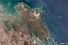
Curtis Island National Park is on Curtis Island, Queensland, Australia, in the Gladstone Region, 474 kilometres (295 mi) northwest of Brisbane and 40 kilometres (25 mi) southeast of Rockhampton.
The island features coastal heaths, littoral rainforest, sand dunes and beach ridges and salt flats.[1] The national park encompasses the Cape Capricorn headland.
No facilities are provided for campers. Bush camping is permitted in three camp grounds.
The island is home to a variety of bird species.[2]
The average elevation of the terrain is 16 metres.[3]
Heritage listings
[edit]Curtis Island has a number of heritage-listed sites, including:
- Sea Hill Point: Sea Hill Light[4]
See also
[edit]References
[edit]- ^ "About Curtis Island". Department of National Parks, Recreation, Sport and Racing. 9 December 2010. Archived from the original on 21 September 2016. Retrieved 10 July 2013.
- ^ Science, jurisdiction=Queensland; sector=government; corporateName=Department of Environment and (4 March 2010). "Curtis Island National Park and Conservation Park". Parks and forests | Department of Environment and Science, Queensland. Retrieved 12 March 2022.
{{cite web}}: CS1 maint: multiple names: authors list (link) - ^ "Curtis Island National Park topographic map, elevation, relief". topographic-map.com. Retrieved 13 March 2022.
- ^ "Little Sea Hill Lighthouse (entry 602784)". Queensland Heritage Register. Queensland Heritage Council. Retrieved 11 July 2015.

