Canchungo: Difference between revisions
Appearance
Content deleted Content added
Rescuing 1 sources and tagging 0 as dead. #IABot (v1.2.7.1) |
info, image |
||
| (12 intermediate revisions by 10 users not shown) | |||
| Line 9: | Line 9: | ||
|motto = |
|motto = |
||
<!-- images and maps -----------> |
<!-- images and maps -----------> |
||
|image_skyline = |
|image_skyline = Canchungo Centro.jpg |
||
|imagesize = |
|imagesize = 250px |
||
|image_caption = |
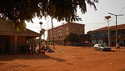
|image_caption = The centre of Canchungo next to the former Teixeira Pinto square. |
||
|image_flag = |
|image_flag = Flag of Canchungo.gif |
||
|flag_size = |
|flag_size = |
||
|image_seal = |
|image_seal = |
||
| Line 87: | Line 87: | ||
|population_footnotes = |
|population_footnotes = |
||
|population_note = |
|population_note = |
||
| ⚫ | |||
|population_total = 6,434 |
|||
|population_density_km2 = |
|population_density_km2 = |
||
|population_density_sq_mi = |
|population_density_sq_mi = |
||
| Line 97: | Line 97: | ||
|population_density_urban_sq_mi = |
|population_density_urban_sq_mi = |
||
|population_blank1_title =Ethnicities |
|population_blank1_title =Ethnicities |
||
|population_blank1 = |
|population_blank1 = [[Manjak people]] |
||
|population_blank2_title =Religions |
|population_blank2_title =Religions |
||
|population_blank2 = |
|population_blank2 = |
||
| Line 107: | Line 107: | ||
|timezone_DST = |
|timezone_DST = |
||
|utc_offset_DST = |
|utc_offset_DST = |
||
|coordinates = {{coord|12|4|2|N|16|2|0|W|type:city_region:GW|display=inline,title}} |
|||
|latd=12 |latm=4 |lats=2 |latNS=N |
|||
|longd=16|longm=2 |longs=0 |longEW=W |
|||
|coordinates_display = inline,title |
|||
|coordinates_type = type:city_region:GW |
|||
|elevation_footnotes = <!--for references: use <ref> </ref> tags--> |
|elevation_footnotes = <!--for references: use <ref> </ref> tags--> |
||
|elevation_m = |
|elevation_m = |
||
| Line 126: | Line 123: | ||
}} |
}} |
||
'''Canchungo''' is a town located in the western [[Cacheu Region]] of [[Guinea-Bissau]] formerly known as Vila Teixeira Pinto after Major Teixeira Pinto, the colonial officer |
'''Canchungo''' is a town located in the western [[Cacheu Region]] of [[Guinea-Bissau]] formerly known as '''Vila Teixeira Pinto''' after Major [[João Teixeira Pinto]], the Portuguese colonial officer who had brutally 'pacified' the area in the early 20th century. After independence the name was changed back to what it had always been. Formerly a center of trade, the town infrastructure has deteriorated significantly amid large-scale emigration, with the exception of a new [[hospital]].<ref>{{cite book |first1=Richard Andrew Jr. |last1=Lobban |first2=Peter Karibe |last2=Mendy |title=Historical Dictionary of the Republic of Guinea-Bissau |edition=4th |publisher=Scarecrow Press |year=2013 |place=Lanham |isbn=978-0-8108-5310-2|page=79}} |
||
</ref> |
|||
| ⚫ | |||
==References== |
==References== |
||
{{Reflist}} |
|||
<references /> |
|||
{{Commons category}} |
|||
{{Authority control}} |
|||
[[Category:Populated places in Guinea-Bissau]] |
[[Category:Populated places in Guinea-Bissau]] |
||
Latest revision as of 18:25, 28 July 2023
Canchungo | |
|---|---|
 The centre of Canchungo next to the former Teixeira Pinto square. | |
| Coordinates: 12°4′2″N 16°2′0″W / 12.06722°N 16.03333°W | |
| Country | |
| Region | Cacheu Region |
| Population (2008 est.) | |
• Total | 6,434[1] |
| • Ethnicities | Manjak people |
Canchungo is a town located in the western Cacheu Region of Guinea-Bissau formerly known as Vila Teixeira Pinto after Major João Teixeira Pinto, the Portuguese colonial officer who had brutally 'pacified' the area in the early 20th century. After independence the name was changed back to what it had always been. Formerly a center of trade, the town infrastructure has deteriorated significantly amid large-scale emigration, with the exception of a new hospital.[2]
References
[edit]- ^ World Gazetteer [dead link], Retrieved on June 16, 2008
- ^ Lobban, Richard Andrew Jr.; Mendy, Peter Karibe (2013). Historical Dictionary of the Republic of Guinea-Bissau (4th ed.). Lanham: Scarecrow Press. p. 79. ISBN 978-0-8108-5310-2.
Wikimedia Commons has media related to Canchungo.


