Pelėdnagiai Eldership: Difference between revisions
Appearance
Content deleted Content added
fixed red links |
|||
| (13 intermediate revisions by 4 users not shown) | |||
| Line 1: | Line 1: | ||
{{Infobox settlement<!--more fields are available for this Infobox--See Template:Infobox Settlement--> |
{{Infobox settlement<!--more fields are available for this Infobox--See Template:Infobox Settlement--> |
||
| |
|official_name = Pelėdnagiai Eldership |
||
| |
|native_name = Pelėdnagių seniunija |
||
| |
|native_name_lang = lt |
||
| |
|settlement_type = [[Elderships of Lithuania|Eldership]] |
||
| |
|leader_title = |
||
| |
|leader_name = |
||
| |
|image_skyline =Pamekliai002.JPG |
||
| |
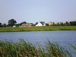
|image_caption = [[Pamėkliai]] village and the [[Labūnava Reservoir]] |
||
| |
|image_map = PelednagiuSeniunija.png |
||
| |
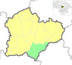
|map_caption = Location of Pelėdnagiai Eldership |
||
| |
|image_shield = |
||
| |
|image_flag = |
||
| |
|coordinates = |
||
| |
|subdivision_type = [[List of sovereign states|Country]] |
||
| |
|subdivision_name = {{LTU}} |
||
| subdivision_type1 |
| subdivision_type1 = [[Regions of Lithuania|Ethnographic region]] |
||
| subdivision_name1 |
| subdivision_name1 = [[Aukštaitija]] |
||
| subdivision_type2 |
| subdivision_type2 = [[Counties of Lithuania|County]] |
||
| subdivision_name2 |
| subdivision_name2 = [[Image:LTU Kauno apskritis flag.svg|20px]] [[Kaunas County]] |
||
| subdivision_type3 |
| subdivision_type3 = [[municipalities of Lithuania|Municipality]] |
||
| subdivision_name3 |
| subdivision_name3 = [[Image:Coat of arms of Kedainiai (Lithuania).svg|20px]] [[Kėdainiai District Municipality]] |
||
| |
|seat_type = [[Administrative centre]] |
||
| |
|seat = [[Pelėdnagiai]] |
||
| |
|area_total_km2 = 141 |
||
|area_footnotes =<ref name=ked/> |
|||
| area_note = |
|||
| population_total = 3780 |
| population_total = 3780 |
||
|population_footnotes = <ref name=census/> |
|||
| |
|population_density_km2 = auto |
||
| |
|population_as_of = 2011 |
||
| |
|population_rank = |
||
| |
|timezone = [[Eastern European Time|EET]] |
||
| |
|utc_offset = +2 |
||
| |
|timezone_DST = [[Eastern European Summer Time|EEST]] |
||
| |
|utc_offset_DST = +3 |
||
| website = |
|||
|website = |
|||
| name = |
|||
}} |
}} |
||
'''Pelėdnagiai Eldership''' ({{ |
'''Pelėdnagiai Eldership''' ({{langx|lt|Pelėdnagių seniūnija}}) is a Lithuanian [[Elderships of Lithuania|eldership]], located in the south eastern part of [[Kėdainiai District Municipality]]. |
||
Eldership was created from the Pelėdnagiai ''[[selsovet]]'' in 1993. |
Eldership was created from the Pelėdnagiai ''[[selsovet]]'' in 1993. |
||
==Geography== |
==Geography== |
||
The territory of Pelėdnagiai Eldership is located mostly in the [[Nevėžis Plain]] and the Nevėžis river valley. Relief is mostly flat, cultivated as agriculture lands. Forests cover about 40 % of the eldership. |
The territory of Pelėdnagiai Eldership is located mostly in the [[Nevėžis Plain]] and the Nevėžis river valley. Relief is mostly flat, cultivated as agriculture lands. Forests cover about 40 % of the eldership.<ref name=ked/> |
||
* Rivers: [[Nevėžis]], Barupė, [[Urka]], [[Mėkla]], [[Lankesa]], [[Ašarėna]] |
* Rivers: [[Nevėžis]], [[Barupė]], [[Urka]], [[Mėkla]], [[Lankesa]], [[Ašarėna]] |
||
* Lakes and ponds: Labūnava Reservoir. |
* Lakes and ponds: [[Labūnava Reservoir]]. |
||
* Forests: Labūnava Forest. |
* Forests: [[Labūnava Forest]]. |
||
* Protected areas: Barupė Hydrographical Sanctuary, Lankesa Botanical Sanctuary, Pelėdnagiai Botanical Sanctuary, Labūnava Forest Biosphere Polygon. |
* Protected areas: [[Barupė Hydrographical Sanctuary]], [[Lankesa Botanical Sanctuary]], [[Pelėdnagiai Botanical Sanctuary]], Labūnava Forest Biosphere Polygon. |
||
==Places of interest== |
==Places of interest== |
||
| Line 60: | Line 60: | ||
Following settlements are located in the Pelėdnagiai Eldership (as for the 2011 census):<ref name=census/> |
Following settlements are located in the Pelėdnagiai Eldership (as for the 2011 census):<ref name=census/> |
||
*Villages: Akmeniai · Ansainiai · Aukupėnai · Baldinka · Beinaičiai · Bučiūnai · [[Eiguliai]] · Gelnai · [[Ivaniškiai, |
*Villages: [[Akmeniai, Kėdainiai|Akmeniai]] · [[Ansainiai]] · [[Aukupėnai]] · [[Baldinka]] · [[Beinaičiai]] · [[Bučiūnai, Kėdainiai|Bučiūnai]] · [[Eiguliai, Kėdainiai|Eiguliai]] · [[Gelnai]] · [[Ivaniškiai, Pelėdnagiai|Ivaniškiai]] · [[Jagminai]] · [[Juciūnai]] · [[Kačergiai, Kėdainiai|Kačergiai]] · [[Kruopiai, Kėdainiai|Kruopiai]] · [[Kudžioniai]] · [[Labūnava]] · [[Liaudiškiai, Kėdainiai|Liaudiškiai]] ·[[Lineliai, Kėdainiai|Lineliai]] · [[Liogailiškiai]] · [[Medekšiai]] · [[Nartautai]] · [[Nociūnai]] · [[Pabarupys]] · [[Pacūnai]] · [[Pamėkliai]] · [[Paobelys]] · [[Pašiliai, Kėdainiai|Pašiliai]] · [[Pėdžiai]] · [[Pelėdnagiai]] · [[Puzaičiai]] · [[Saviečiai]] · [[Serbinai]] · [[Servitgaliai]] · [[Sičioniai]] · [[Slikiai]] · [[Stašaičiai]] · [[Šilainėliai]] · [[Šilainiai, Pelėdnagiai|Šilainiai]] · [[Užkapiai]] · [[Vainiūnai, Kėdainiai|Vainiūnai]] · [[Zabieliškis]] · [[Žiogaičiai, Kėdainiai|Žiogaičiai]] |
||
* Hamlets: [[Rimuoliai]] |
* Hamlets: [[Rimuoliai]] |
||
* Railway station settlements: [[Slikių GS]] |
* Railway station settlements: [[Slikių GS]] |
||
| Line 68: | Line 68: | ||
{{reflist|refs= |
{{reflist|refs= |
||
<ref name=census>{{cite web|url=http://statistics.bookdesign.lt/table_125_02.htm?lang=en|title=2011 census|publisher=Statistikos Departamentas (Lithuania)|accessdate=August 21, 2017}}</ref> |
<ref name=census>{{cite web|url=http://statistics.bookdesign.lt/table_125_02.htm?lang=en|title=2011 census|publisher=Statistikos Departamentas (Lithuania)|accessdate=August 21, 2017}}</ref> |
||
<ref name=ked>{{cite web|url=http://old.kedainiai.lt/go.php/lit/Trumpai-apie-seniunija/1|title=Trumpai apie seniūniją|publisher=Kėdainių rajono savivaldybė|accessdate=2021-01-01}}</ref> |
|||
}} |
}} |
||
Latest revision as of 20:04, 10 November 2024
Pelėdnagiai Eldership
Pelėdnagių seniunija | |
|---|---|
 Pamėkliai village and the Labūnava Reservoir | |
 Location of Pelėdnagiai Eldership | |
| Country | |
| Ethnographic region | Aukštaitija |
| County | |
| Municipality | |
| Administrative centre | Pelėdnagiai |
| Area | |
• Total | 141 km2 (54 sq mi) |
| Population (2011)[2] | |
• Total | 3,780 |
| • Density | 27/km2 (69/sq mi) |
| Time zone | UTC+2 (EET) |
| • Summer (DST) | UTC+3 (EEST) |
Pelėdnagiai Eldership (Lithuanian: Pelėdnagių seniūnija) is a Lithuanian eldership, located in the south eastern part of Kėdainiai District Municipality.
Eldership was created from the Pelėdnagiai selsovet in 1993.
Geography
[edit]The territory of Pelėdnagiai Eldership is located mostly in the Nevėžis Plain and the Nevėžis river valley. Relief is mostly flat, cultivated as agriculture lands. Forests cover about 40 % of the eldership.[1]
- Rivers: Nevėžis, Barupė, Urka, Mėkla, Lankesa, Ašarėna
- Lakes and ponds: Labūnava Reservoir.
- Forests: Labūnava Forest.
- Protected areas: Barupė Hydrographical Sanctuary, Lankesa Botanical Sanctuary, Pelėdnagiai Botanical Sanctuary, Labūnava Forest Biosphere Polygon.
Places of interest
[edit]- Catholic church of the Divine in Labūnava
- Juciūnai cemetery chapel
- Aukupėnai cemetery tomb-chapel
- Labūnava manor tower
- Gelnai wayside chapel
- Ancient burial site in Nociūnai and former cemetery site in Pašiliai
- Soviet mosaic the "Land Improvers" in Pelėdnagiai
Populated places
[edit]Following settlements are located in the Pelėdnagiai Eldership (as for the 2011 census):[2]
- Villages: Akmeniai · Ansainiai · Aukupėnai · Baldinka · Beinaičiai · Bučiūnai · Eiguliai · Gelnai · Ivaniškiai · Jagminai · Juciūnai · Kačergiai · Kruopiai · Kudžioniai · Labūnava · Liaudiškiai ·Lineliai · Liogailiškiai · Medekšiai · Nartautai · Nociūnai · Pabarupys · Pacūnai · Pamėkliai · Paobelys · Pašiliai · Pėdžiai · Pelėdnagiai · Puzaičiai · Saviečiai · Serbinai · Servitgaliai · Sičioniai · Slikiai · Stašaičiai · Šilainėliai · Šilainiai · Užkapiai · Vainiūnai · Zabieliškis · Žiogaičiai
- Hamlets: Rimuoliai
- Railway station settlements: Slikių GS
- Former settlements: Činkiai
References
[edit]- ^ a b "Trumpai apie seniūniją". Kėdainių rajono savivaldybė. Retrieved 2021-01-01.
- ^ a b "2011 census". Statistikos Departamentas (Lithuania). Retrieved August 21, 2017.

