Hesperange: Difference between revisions
Citation bot (talk | contribs) Misc citation tidying. | You can use this bot yourself. Report bugs here. | Suggested by Abductive | Category:Articles containing Luxembourgish-language text | via #UCB_Category 300/789 |
No edit summary |
||
| Line 50: | Line 50: | ||
| footnotes = |
| footnotes = |
||
}} |
}} |
||
'''Hesperange''' ({{IPA-fr|ɛspəʁɑ̃ʒ}}; {{lang-lb|Hesper}} |
'''Hesperange''' ({{IPA-fr|ɛspəʁɑ̃ʒ}}; {{lang-lb|Hesper}} {{IPA-lb|ˈhæspɐ|}}; {{lang-de|Hesperingen}}) is a [[Communes of Luxembourg|commune]] and town in southern [[Luxembourg]]. It is located south-east of [[Luxembourg City]]. |
||
The total population of the commune is 14.701 people. This breaks down into 6.909 Luxembourgers, 2.021 French, 1.758 Portuguese, 1.052 Italians, 627 Belgians, 514 Germans, 241 Spanish, 207 British, 190 Polish, 106 Dutch, and 1.076 persons of other nationalities. (2014 official data) |
The total population of the commune is 14.701 people. This breaks down into 6.909 Luxembourgers, 2.021 French, 1.758 Portuguese, 1.052 Italians, 627 Belgians, 514 Germans, 241 Spanish, 207 British, 190 Polish, 106 Dutch, and 1.076 persons of other nationalities. (2014 official data) |
||
Revision as of 15:04, 1 February 2021
Hesperange
Hesper | |
|---|---|
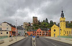
 View on Hesperange with its castle | |
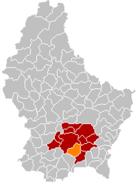
 Map of Luxembourg with Hesperange highlighted in orange, and the canton in dark red | |
| Coordinates: 49°34′15″N 6°09′05″E / 49.5708°N 6.1514°E | |
| Country | |
| Canton | Luxembourg |
| Government | |
| • Mayor | Marc Lies |
| Area | |
• Total | 27.22 km2 (10.51 sq mi) |
| • Rank | 32nd of 102 |
| Highest elevation | 334 m (1,096 ft) |
| • Rank | 90th of 102 |
| Lowest elevation | 255 m (837 ft) |
| • Rank | 58th of 102 |
| Population (2023) | |
• Total | 16,433 |
| • Rank | 7th of 102 |
| • Density | 600/km2 (1,600/sq mi) |
| • Rank | 14th of 102 |
| Time zone | UTC+1 (CET) |
| • Summer (DST) | UTC+2 (CEST) |
| LAU 2 | LU0000303 |
| Website | hesperange.lu |
Hesperange (French pronunciation: [ɛspəʁɑ̃ʒ]; Template:Lang-lb [ˈhæspɐ]; Template:Lang-de) is a commune and town in southern Luxembourg. It is located south-east of Luxembourg City.
The total population of the commune is 14.701 people. This breaks down into 6.909 Luxembourgers, 2.021 French, 1.758 Portuguese, 1.052 Italians, 627 Belgians, 514 Germans, 241 Spanish, 207 British, 190 Polish, 106 Dutch, and 1.076 persons of other nationalities. (2014 official data)
As of 2008[update], the town of Hesperange, which lies in the centre of the commune, has a population of 2.651. Other towns within the commune include Alzingen, Fentange, Howald, and Itzig. Each of these five towns has a population of over 1,000, making Hesperange unique amongst Luxembourgian communes in having five towns with over a thousand inhabitants (see: List of towns in Luxembourg by population).
The mayor of the commune is Marc Lies.
Hesperange is home of FC Swift Hesperange, a football club that plays in the top-flight National Division. The club's home games are played at Stade Alphonse Theis. They have won the Luxembourg Cup on one occasion (1989–90).
Hesperange Castle, now a ruin, has a history dating from the 13th century.[1]
Hesperange has a park called Hesper Park which has a memorial commemorating the death of three American soldiers who died in a tank accident on the nearby bridge over the Alzette river on 26 December 1944 during the Battle of the Bulge.
Photo gallery
-
Municipality Building
-
Hesperange at Night
-
Highway Bridge
-
Winter Fields
Twin towns — sister cities
Hesperange is twinned with:[2]
References
- ^ "Hesperange: History", Association des châteaux luxembourgeois. Retrieved 3 April 2011.
- ^ "Jumelage". hesperange.lu (in French). Hesperange. Retrieved 2019-09-04.
External links
 Media related to Hesperange at Wikimedia Commons
- Commune de Hesperange (Municipality of Hesperange)
- Friends of the History of Hesperange
- Hesperange Schools


